Key Highlights:
- Windy conditions developing Monday afternoon, continuing through Tuesday afternoon
- Much colder air looks to spread into our area early next week, likely to bring 2 or 3 nights of hard freezes.
Monday has turned out to be an active weather day, with a Pacific cold font pushing southeast across our area. As of 2 pm, the cold front stretched from Tyler, to near Smithville, to just east of Dallas, to Austin, to near Cotulla. The front is forecast to continue pushing southeast this afternoon, reaching the Interstate 10 corridor between 4 and 6 pm, then move off the coast between 6 and 8 pm.
Ahead of the cold front, the atmosphere across the middle Texas coast and the eastern counties of Central Texas has become quite moist and fairly unstable. Isolated strong to severe thunderstorms will be possible across this area over the course of the afternoon. But the primary focus for the development of severe storms will be with a band of showers and thunderstorms that has developed along and just behind the cold front. The Storm Prediction Center has placed Colorado, Wharton, and Matagorda Counties under a Slight Risk (a 2 out of 5 risk) for severe thunderstorms through Monday evening. Travis, Bastrop and Fayette Counties have been placed under a Marginal Risk (a 1 our of 5 risk) for severe thunderstorms. All hazards will be in play with today’s storms–large hail, damaging winds, and isolated tornados. The threat for severe storms will diminish once the cold front passes by.
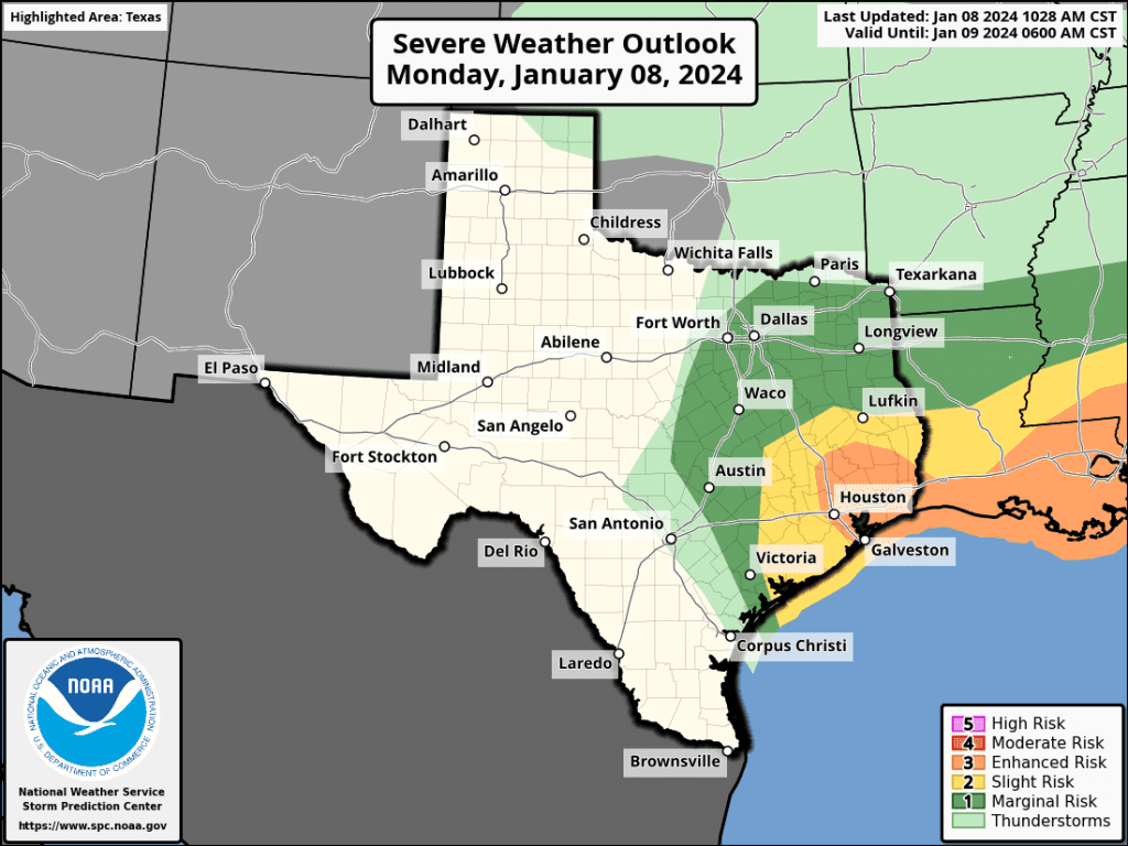
- The Storm Prediction Center has issued a Tornado Watch for Southeast Texas, including Colorado and Wharton Counties, until 9 pm Monday evening.
The rain and storms will end shortly behind the cold front. Rain amounts from the afternoon showers and thunderstorms is not expected to be very heavy, with most amounts expected to stay below a half inch. A couple of isolated totals to near 1 inch will be possible.
Partly cloudy, cooler, and windy weather will develop across the region behind the cold front Monday afternoon and Monday night. A strengthening pressure gradient behind the departing cold front and low pressure area is forecast to cause the development of windy conditions Monday afternoon, with even stronger winds arriving Monday night into midday Tuesday. Wind speeds will decrease Tuesday evening.
- Monday afternoon, expect westerly winds with speeds of 15-25 mph, and occasional gusts to 35 mph.
- Monday night through midday Tuesday, expect westerly winds with speeds of 20-30 mph, with occasional gusts to 45-50 mph.
- Wind speeds should lower slightly to 20-30 mph with fewer gusts Tuesday afternoon, then decrease to around 5-10 mph Tuesday night.
- Wind speeds are predicted to increase to a range of 15-20 mph, with occasional gusts to 30 mph Wednesday afternoon.
Sunny and dry weather is forecast Tuesday through Thursday. High temperatures are forecast to be in the mid-50s Tuesday, warming to the mid-60s Wednesday, and the low 70s Thursday. Lows Tuesday and Wednesday mornings are forecast to be in the mid and upper 30s. Lows Thursday morning will range from around 40 degrees west, to the lower 50s near the coast.
Forecasts call for a slight chance for rain showers and thunderstorms to develop across the region Thursday night into early Friday morning as a fairly strong cold front sweeps south through the region. The probability for rain will only be around 30 percent, with rain amounts staying well below a quarter of an inch.
The cold front is forecast to bring colder temperatures for the weekend. Under a sunny sky, highs both days are forecast to be in the mid-50s. Lows Saturday and Sunday mornings will range from the upper 20s to low 30s across the Hill Country, to the mid-30s across Central Texas, to the upper 30s across the coastal plains.
Turning Much Colder Next Week
A cold pattern is forecast to develop for areas east of the Rockies early week as a large trough of low pressure over southeastern Canada dislodges a swath of arctic air and sends it south down the lee side of the Rockies. This arctic air mass is forecast to spread across Central Texas sometime Sunday night into Monday morning, with the cold air remaining in place through the first half of next week. This air will likely be the coldest air our region has seen so far this winter. A hard freeze is predicted for most locations.
- High temperatures next Monday and Tuesday are forecast to generally be in the mid and upper 40s, warming to the low and mid-50s on Wednesday.
- Lows next Monday morning are forecast to dip to the mid-20s across the Hill Country, the upper 20s across Central Texas, and the low 30s across the coastal plains.
- Lows next Tuesday and Wednesday mornings are forecast to be in the upper teens to low 20s across the Hill Country, the low and mid-20s across Central Texas, and the upper 20s across the coastal plains.
Forecast solutions are indicating a low chance some very light precipitation may develop late Sunday night into Monday morning across the Hill Country and parts of Central Texas. Model discrepancies regarding the timing of the sub-freezing temperatures in relation to when the moisture will be available creates too much uncertainty at this point to have any confidence there will be any wintery precipitation. As of now, the thought is the precipitation will remain liquid before the subfreezing temperatures arrive, or the weather will remain dry. This situation will need to be watched over the next few days as model solutions become more clear.
Dry and slightly warmer weather is forecast for late next week, with highs in the 50s and lows in the 30s.
Bob
Social Media