A quick update on holiday weekend weather conditions. Forecasted rain amounts have increased a bit, low temperatures have decreased slightly, and Christmas Day weather is now expected to be sunny.
Light rain developed early Thursday morning and spread across most of the Hill Country and the Austin/I-35 corridor regions. Rain amounts as of midday Thursday generally averaged below 0.20 inches, although there have been several isolated totals to around a half inch.
A cloudy, mild, and somewhat unsettled weather pattern is taking shape across much of Texas thanks to a wave of low pressure that is slowly tracking northeast into Texas out of Mexico. With moisture increasing off the Gulf of Mexico, occasional light rain showers are forecast to expand in areal coverage and persist across the region Thursday afternoon through Friday afternoon. The probability for rain will be near 50-60 percent. Rain amounts through Friday evening are forecast to generally average around a quarter to a half inch.
The chance for rain is expected to decrease Friday evening into early Saturday morning as the wave of low pressure exits to the northeast.
- High temperatures Thursday will range from the mid-60s west, to the low 70s near the coast.
- Low temperatures Friday and Saturday mornings will be between 55 and 60 degrees.
- High temperatures Friday and Saturday are forecast to be near 68-70 degrees.
- Lows Sunday morning will range from the mid-50s west, to the mid-60s across the coastal area.
The main weather story of the Holiday Weekend continues to be the good chance for widespread rain showers and scattered thunderstorms occurring between Saturday evening and late Sunday afternoon. The large trough of low pressure that is currently bringing heavy rain to southern California is forecast to track east to the Desert Southwest Friday, then turn northeast to the southern Plains states late Saturday into Sunday. The trough will help push a Pacific cold front across the state Sunday, with the front being the focus for the development of rain and scattered storms.
Showers and scattered thunderstorms are predicted to increase in areal coverage Saturday evening and continue into Sunday afternoon. The threat for any strong to severe storms appears low. Meanwhile, periods of moderate to occasionally heavy rain are forecast. With a very moist air mass in place, a few locally heavy downpours cannot be ruled out. The rain is now forecast to end from west to east late Sunday afternoon through Sunday evening as drier air spreads in behind the Pacific cold front.
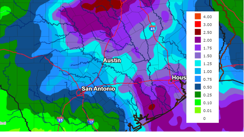
Rain amounts between Saturday night and Sunday evening are forecast to generally total between 1 and 2 inches across the Hill Country and the Austin/Interstate 35 corridor, and between 1 and 3 inches across the eastern half of Central Texas and the middle Texas coast.
NWS Total Rainfall Forecast, Valid through 6 pm Sunday:
Clouds look to clear Sunday evening and Christmas Day is shaping up to sunny and pleasant. Expect a high temperature in the low 60s. Northwesterly winds will develop behind the cold front Sunday evening and continue through Christmas Day. Wind speeds of 10-20 mph, with occasional gusts to 30 mph are forecast Monday into Monday evening.
A sunny and dry weather pattern is forecast next Tuesday through Friday. High temperatures next week are predicted to generally be in the low 60s. Lows are forecast to be in the mid-30s across the Hill Country, the upper 30s across Central Texas, and the low 40s across the coastal plains.
Bob
Social Media