Severe storms spread southeast across the eastern Hill Country, from Enchanted Rock, through Johnson City, to San Marcos Thursday evening. Another area of severe storms tracked from eastern Williamson County through Lee County. These damaging storms produced very large hail of generally 1 to 3 inches in diameter. The largest hail appears to have fallen in and around Johnson City, in Blanco County, where 4 to 5 inch diameter hail was observed. The National Weather Service is confirming one of the hail stones in Johnson City measured 6.25 inches in diameter! This is just shy of the Texas record for largest hail stone which fell near Hondo in April, 2021. That stone measured 6.42 inches in diameter.
Quiet and more stable weather has developed across the region following the passage of a weak cold front late Thursday night. The air behind the front is noticeably drier and just slightly cooler. Another benefit to the front is that is has pushed out the haze and smoke that’s plagued our area throughout the week.
Friday’s weather will include a mostly sunny to partly cloudy sky and less hot temperatures. Dry weather is forecast at most locations. However, there will be a 20-30 percent chance for a few scattered showers and thunderstorms across the region as a weak wave of low pressure pushes northeast over the area. The threat for any of these storms being severe will be quite low.
- Friday’s high temperature will range from the upper 70s across the northern Hill Country, to low 80s across Central Texas, to the mid and upper 80s near the coast.
- Lows Saturday morning will include the low 60s across the Hill Country, the low and mid-60s across Central Texas, and the upper 60s across the coastal plains.
A change in the weather is predicted to take place Saturday as trough of low pressure begins to push east out of the Arizona and New Mexico. Moisture is forecast to begin retuning off the Gulf of Mexico Saturday ahead of the upper trough. Expect a partly to mostly cloudy sky throughout the day. There will be a slight chance for a few scattered showers and isolated thunderstorms beginning Saturday afternoon, continuing through Saturday evening. Chances for any severe storms looks to be quite low.
Atmospheric conditions across the Hill Country, Central Texas, and the middle Texas coast ahead of the approaching trough are shaping to be quite favorable for the development of waves of rain showers and scattered thunderstorms beginning around midnight Saturday night, continuing through Sunday and Sunday night. The probability for rain will be near 80 percent. Some of the ingredients for severe thunderstorms will also be in place. The Storm Prediction Center has placed the entire region under a Marginal Risk, or 1 out of 5 risk, for severe thunderstorms. The primary severe weather threats will be large hail and damaging winds.
The waves of rain and thunderstorms are forecast to continue into Monday, then slowly taper off from west to east Monday afternoon as the upper trough exits our region. A weak cold front moving through the area Monday afternoon will bring in drier and slightly cooler air.
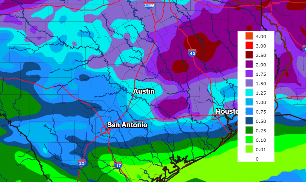
Rain amounts from Saturday night through Tuesday morning are forecast to generally average around an inch across the Hill Country, and between 1 and 2 inches at most other locations.
NWS Rainfall Forecast Valid from 7 pm Friday through 7 pm Monday:
Clouds are forecast to clear Monday night. This will be followed by a mostly sunny sky on Tuesday.
- Highs Sunday are forecast to be in the upper 70s to low 80s.
- Highs Monday are forecast to be in the mid and upper 80s.
- Highs Tuesday are predicted to be in the upper 80s.
A chance for rain and scattered thunderstorms looks to return to the forecast next Wednesday and Thursday when a trough of low pressure dips south out of the southern Plains and moves across North Texas. The atmospheric setup with the approaching trough is looking somewhat favorable for the development of strong to severe thunderstorms across the Hill Country and parts of Central Texas both days. Rain amounts for both days are forecast to generally average between 1 and 1.5 inches.
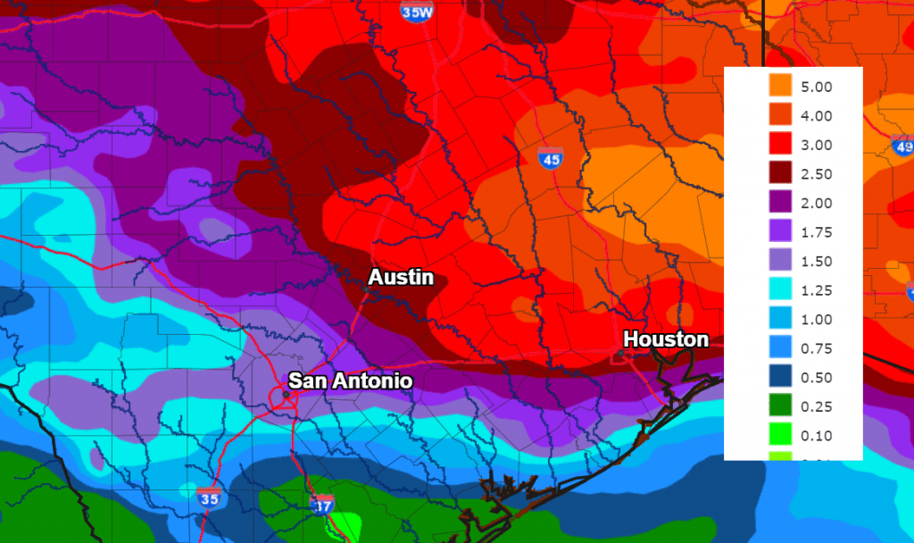
Adding the forecast rainfall early in the week with the rain forecast Wednesday and Thursday, amounts of 1-2 inches are forecast across the Hill Country, with 2-4 inch totals at most other locations.
NWS Rainfall Forecast for the Period 7 pm Friday through 7 pm Next Friday:
A dry and warmer weather pattern is forecast to develop next Friday when a ridge of high pressure builds north out of Mexico. This pattern is predicted to continue next weekend and into the following week. Expect daily high temperatures to be in the low 90s.
Wishing everyone a Happy Mother’s Day Weekend.
Bob
Social Media