A wet weather pattern continues across Central and South Texas. As of early Thursday afternoon, the highest totals of rain so far have occurred across Deep South Texas and the Coastal Bend regions, with much lower totals further recorded further to the north. The western half of the Hill Country had yet to receive any rain.
A widespread coverage of rain showers and scattered thunderstorms is forecast across the region Thursday evening and Thursday night, continuing through Friday afternoon as a large trough of low pressure pushes east out of northern Mexico. With a very moist air mass in place, showers and scattered thunderstorm activity is expected to increase as the upper trough pushes east into Texas. Waves of showers and thunderstorms are forecast to spread over the area Thursday night, continuing through Friday. Some of the rain may at times be locally heavy. The probability for rain will be near 50 percent across the Hill Country and near 90-100 percent across Central Texas and the middle Texas coast.
Thursday’s forecast model solutions continue to struggle with the location of the highest rain totals over the next 24 hours. It’s worth noting there’s been a general trend over the last few model runs for the highest totals of rain to continue to be across the Coastal Bend region and the middle Texas coast, with lower totals further inland. As a result, updated rainfall forecasts now call for lower rain totals for the Hill Country and Central Texas regions, compared to earlier forecasts.
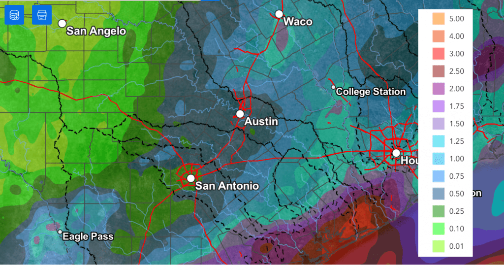
Updated National Weather Service rainfall forecasts through late Friday afternoon call for totals of 0.25 to 0.5 inches across the western and central Hill Country, with totals of 0.5 to 1.25 inches across Central Texas. For the middle Texas coast, totals of 1-3 inches are forecast, with isolated amounts to near 5 inches possible.
NWS Rainfall Forecast Valid through 7 pm Friday:
A Flood Watch remains posted for Colorado, Wharton, and Matagorda Counties through Friday evening.
A very low-end threat for strong to severe thunderstorms will continue for most of the area through Friday afternoon. It will be possible an isolated thunderstorms or two could produce large hail and damaging winds. But a widespread severe threat is certainly not anticipated.
A chance for additional light rain showers will continue into Friday evening. However, the chance for rain is predicted to end from west to east late Friday evening and toward midnight as the upper trough finally exits to the northeast.
This weekend’s weather is forecast to be mostly sunny and warm, with high temperatures in the mid-80s. The next chance for rain is expected to occur late week when a new trough of low pressure tracks east from the southwestern U.S.
Bob
Social Media