Here’s my Wednesday update on the arctic outbreak which is finally moving out.
Key Messages
- The arctic air is exiting Texas. Readings will warm well above freezing this afternoon
- Temperatures Wednesday night won’t be nearly as cold, with lows in the 30s
- The next arctic cold front is predicted to push through the area Thursday evening and Thursday night. There will be no precipitation along the cold front
- Windy and much cooler weather will follow Thursday night through Friday. Expect northerly winds with speeds of 15-25 mph, and occasional gusts to 40 mph
- Friday night will be the coldest night ahead, with lows Saturday morning in the low and mid-20s
- Weekend temperatures will be cool, with highs both days in the 40s
- Mild temperatures will return Sunday night and continue through all of next week
- Forecasters continue to monitor the development of a wet weather pattern across the region next week
Discussion
The bitter cold which has gripped our area since Sunday is finally on the way. With the center of the arctic high pressure system to our east, southerly breezes have returned to most of Texas. Wind speeds are forecast to be in the range of 10-15 mph, with occasional higher gusts through Wednesday night. A slow warm up can be expected today into tonight, with even warmer temperatures on Thursday.
- High temperatures Wednesday will generally be in the upper 40s.
- Lows Thursday morning are forecast to be in the low 30s across the Hill Country and Central Texas regions, and in the mid to upper 30s towards the coast.
- Temperatures Thursday look to climb to near 68-70 degrees.
Forecasters continue to follow the progress of the next arctic cold front that is currently pushing south out of western Canada. The front is predicted to push across our region Thursday evening into Thursday night. There will be no rain along or behind the cold front. Thankfully, the air behind this next front won’t be quite as cold as what we’ve been seeing for the past couple of days. However, it will still be a cold end to the workweek and the weekend. Breezy to windy conditions and colder weather will develop behind the cold front Thursday night and continue through Friday. The coldest temperatures should occur Friday night into Saturday morning. Expect northerly winds with speeds of 15-25 mph and occasional gusts as high as 40 mph. Winds are forecast to decrease some Friday night. A hard freeze is forecast Friday night into early Saturday.
- Low temperatures Friday morning will range from the mid-20s across the Hill Country, to the low 30s across Central Texas, to the upper 30s across the coastal plains.
- High temperatures Friday are forecast to be around 40-42 degrees.
- Lows Saturday morning are predicted to be near 20 degrees across the Hill Country, in the low 20s across Central Texas, and in the mid to upper 20s across Central Texas.
Chilly temperatures are forecast to continue this weekend. Expect a mostly sunny sky Saturday, with the sky becoming mostly cloudy Saturday night through Sunday.
- High temperatures Saturday will be in the low 40s.
- Lows Sunday morning will range from the upper 20s across the Hill Country to the middle 30s towards the coast.
- High temperatures Sunday are forecast to be in the mid-40s.
- Near-steady or slowly warming temperatures can be expected Sunday night.
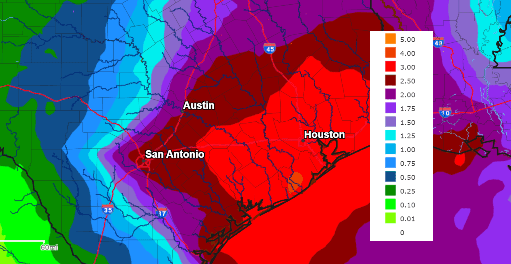
An unsettled weather pattern will develop late Sunday and is expected for much of next week as a series of Pacific low pressure troughs push across Mexico and over Texas. Each of these troughs will tap abundant Gulf moisture, and bring widespread rain and scattered thunderstorms to the entire region. There is a fairly good potential for some of the rain to be heavy at times next week. The chance for rain will increase beginning Sunday night, with a 60-70 percent chance for rain forecast Monday through Wednesday. High temperatures next week are predicted to be in the 60s.
The National Weather Service’s rainfall forecast valid through next Wednesday evening calls for totals of 2.5 to 4 inches for areas along and east of Interstate 35. Totals of 1-2 inches are forecast across the Hill Country.
Bob
Social Media