Weather Pattern Showing Very Few Changes Over the Next Week and Longer
July 31, 2023
Weather conditions remained dry and very hot over the weekend as our region remained under the influence of a massive heat dome situated over the western and central U.S. Unfortunately, even the very isolated rain showers we saw late last week across the coastal plains came to an end. High temperatures both days were generally near 100-104 degrees. Preliminary data indicates July 2023 will end up being one of the hottest, if not the hottest July on record across the majority of the area.
As we start off the new week, there are few changes in the weather pattern to talk about. The biggest item of concern continues to be the position of the heat dome and its center. Late last week, the center of the heat dome was located between Phoenix and Albuquerque. Over the weekend, the dome center moved slowly to the east and as of Monday morning, it was located across western Oklahoma and northwest Texas. Forecasts call for the dome center to settle over central and northeastern Texas late this week, then reform out west across the Four Corners region over the weekend and early next week.
Sinking air underneath the heat dome and around the periphery of the dome center will causing a dry, hot, and very stable atmosphere across all of Texas this week. No rain is predicted—even along the coastal plains. The biggest weather news will continue to be the unrelenting heat. High temperatures are forecast to be very consistent this afternoon and through the upcoming weekend.
- Daily high temperatures Monday afternoon through next Sunday afternoon are predicted to be near 103-106 degrees across the Hill Country and Central Texas regions, and near 98-101 degrees across the coastal plains.
So this brings us to the outlook for next week and beyond. Everyone is so ready for a break from the heat and dry weather. Unfortunately, next week is showing little to no change in the weather pattern. Forecasts call for the heat dome to remain across Texas next week, with the dome to be centered over northern Mexico and Far West Texas. With the dome center to our west, it might allow for a few isolated sea breeze rain showers near the coast. Otherwise, the dry and very hot pattern will continue. High temperatures are predicted to remain very close to what is forecast for this week.
Looking out further in the week of August 14th, extended range forecasts are unfortunately showing few changes in the very hot and dry pattern.
**A reminder that heat safety precautions remain critical! Taking protective actions such as remaining hydrated and avoiding strenuous activity during the hottest parts of the day can be life-saving! Heat is the number one weather-related cause of death across the U.S. each year.
Elevated Fire Weather Conditions Continue
From the Texas Forest Service:
Fire environment conditions the first week of August will likely support a high volume of wildfire response for a broad area of Texas. Wednesday will feature high significant fire potential as critical fire weather is forecast over critically to extremely dry fuel for areas along and west of I-35 and into Central and East Texas. Wildfires will likely exhibit high resistant to control in high risk, oak/juniper fuel for the Western/Eastern Hill Country and Cross Timbers. High risk, pine fuel will support high resistance to control in Central Texas, Southeast Texas, and the Western Pineywoods. Tuesday and Thursday will feature moderate significant fire potential as elevated fire weather occurs over critically to extremely dry fuel in the Western/Eastern Hill Country, Cross Timbers, Southeast Texas, Western Pineywoods, and Central Texas.
Tropical Weather Outlook
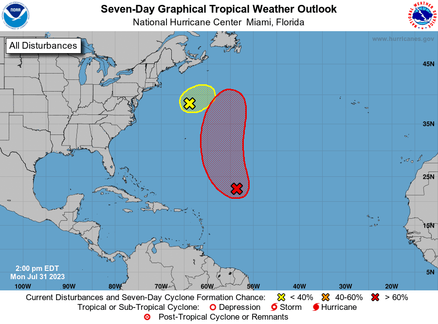
Weather conditions are quiet across the Gulf of Mexico and the Caribbean Sea. There are no systems in place which pose a threat for tropical development over the next seven days.
National Hurricane Center forecasters are closely monitoring an area of showers and thunderstorms associated with an area of low pressure located about 650 miles northeast of the northern Leeward Islands. These showers have become less organized since last night. However, the system is producing a small area of gale-force winds well to the east of the center. Environmental conditions still appear somewhat conducive for a tropical depression or tropical storm to develop during the next couple of days while the system moves northwestward and then northward at 10 to 15 mph over the central subtropical Atlantic. This system poses no threat to the Gulf of Mexico. NHC forecasters are giving this system a high chance (70 percent chance) for tropical development over the next seven days.
NHC forecasters are also monitoring shower and thunderstorm activity over the northwestern Atlantic, several hundred miles south of Nova Scotia. This activity is associated with a gale-force low pressure system located several hundred miles south of Nova Scotia. However, recent satellite data indicate that the low is attached to frontal boundaries, and it is forecast to move quickly toward the east-northeast at 30 to 35 mph, reaching colder waters by Monday night. As a result, the likelihood of this system becoming a tropical storm is now diminishing. NHC forecasters are giving this system a low chance (10 percent chance) for tropical development over the next seven days.
Full Moon Tuesday will the First of Two August Full Moons
The full moon on August 1st will be the second of four supermoons that will occur in the summer of 2023. The next Full Blue Moon, will fall on Aug. 30th.
Tuesday’s full moon will rise at 1:31 pm CDT. This means it will also appear full Monday evening and Wednesday evening.
So-called supermoons occur because the orbit of the moon around the Earth is not a perfect circle but is instead a flattened circle or an ellipse. This means that during its 27.3-day orbit, there are points at which the moon is closer to the Earth and points at which it is further away. The visible size difference of the moon between the closest point, perigee, and the furthest, apogee, is about 14%. Supermoons can result in around a 30% brightening of the moon and a 14% increase in the size of the lunar disk as seen from Earth. These differences are visible to moon-watchers with a lot of experience observing lunar events but aren’t that noticeable with the unaided eye if you don’t pay a lot of attention to the moon nightly.
Have a good week.
Bob
Social Media