A resilient, late-summer-like weather pattern will continue over the weekend and the first half of next week thanks to a persistent ridge of high pressure located over the southwestern U.S. and northern Mexico. With the ridge in place, no significant change in the weather is forecast through next Tuesday. A pattern of late night clouds and afternoon sunshine looks to continue.
In the near-term, forecasters are keeping watch on a weak cold front that slipped south into Northwest Texas Thursday night. The front is expected to spread south into the Hill Country and parts of Central Texas Friday afternoon into Friday evening, stalling just to the north of Austin and Fredericksburg Friday night. No rain is forecast with the cold front. Areas north of the front are predicted to see slightly cooler temperatures Friday night into Saturday morning. The front is forecast to return back to the north on Saturday.
Southerly winds with speeds of 5-10 mph and occasional gusts to 15 mph are predicted Friday afternoon through Monday.
Breezy to somewhat windy conditions are forecast to develop next Tuesday and Wednesday as the pressure gradient strengthens across the state ahead of a storm system across the West. Expect southerly winds with speeds of 10-20 mph and occasionally gusts of 30-35 mph. Note: the combination of very warm temperatures, gusty winds, and critically dry vegetation may be sufficient for fire initiation and fire spread. Continue to avoid activities that could produce fire starts and remember to obey local burn bans and regulations.
- High temperatures Friday through Tuesday are forecast to generally be between 88 and 90 degrees across Central Texas and the middle Texas coast. Hill Country high temperatures are forecast to be in the mid and upper 80s
- Lows Saturday morning will range from the upper 50s across the northern Hill Country, to the mid-60s across Central Texas, to the upper 60s near the coast
- Lows Sunday morning through Tuesday morning are predicted to be in the low 60s across the Hill Country, and in the mid and upper 60s at most other locations
Forecasts call for a large trough of low pressure to push inland along the coast of California and the Pacific Northwest early next week. The trough is forecast to push east across the Rockies then turn northeast into central and northern Plains the second half of next week. In addition, the trough is forecast to finally push the persistent ridge of high pressure off to the east, finally opening the door for some weather changes across our region.
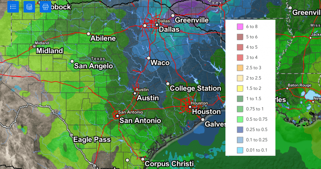
Moisture will increase off the Gulf of Mexico beginning next Wednesday. With a less stable atmosphere in place, there will be a 20 percent chance for some scattered, spotty, afternoon and rain showers across the region. Rain amounts, if any, will only average around a tenth of an inch.
A somewhat better chance for rain and scattered thunderstorms is forecast late Wednesday night through Thursday when a Pacific cold front sags southeast into the area. As of now, it’s not clear how far south the front will track, but conditions ahead of and along the front appear favorable for the development of scattered showers and thunderstorms. The probability for rain will near 30-40 percent. Rain amounts Thursday are forecast to generally average between 0.25 and 0.5 inches. Longer-range forecasts call for just a slight chance for rain across the region next Friday. This will be followed by a slightly better chance for rain next weekend and the early part of the following week as an area of low pressure stalls over the southwestern U.S.
NWS Rainfall Forecast Valid through 7 pm next Friday:

Temperatures are predicted to trend slightly cooler late next week into next weekend, with highs falling to the mid 80s. A change to more fall-like temperatures are forecast beginning sometime around Sunday the 3rd, when a Canadian cold front pushes south across the area. High temperatures the week of November 4th are forecast to be in the 70s, with lows in the 50s. Could fall finally be making an appearance???
Tropical Weather Update
Weather conditions are currently quiet across the Atlantic basin. Tropical cyclone development is not expected over the next seven days.
Comet Tsuchinshan-ATLAS Update
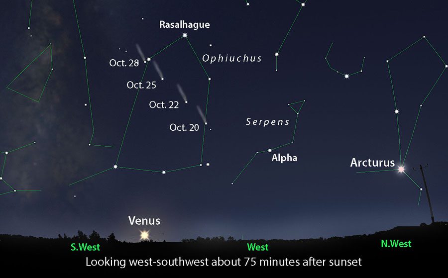
Comet Tsuchinshan-ATLAS (pronounced “tzeh-chin-SHAHN”) continues to shrink and fade as it recedes into the distance in the western sky right after nightfall. It is now too faint to be seen with the unaided eye, but it’s still a fine target for binoculars and telescopes. Look for it in beginning in late twilight well above Venus. The comet will remain visible through late October and into early November.

Courtesy Sky and Telescope
Have a great weekend!
Bob


Social Media