Forecast for Central Texas

 0%
0% 0%
0% 0%0%0%
Reports from LCRA’s Hydromet
Rainfall summaryTemperature summary
Humidity summary
Bob's Blog on Central Texas Weather
A Chance for Rain Forecast through the Middle of Next Week. Expect a Short Break in the Heat
It’s been a hot week as the summer pattern began to take shape in earnest across the area. In fact, many locations this week recorded their hottest temperatures so far this summer. However, a break in the summer pattern will be developing this weekend and the first half of next week as the heat dome shifts well up to the north, allowing moisture and atmospheric disturbances to spread over the area. Slightly lower temperatures this weekend will include a slight chance for scattered showers and thunderstorms. Chances for rain are expected to be the highest Monday and Tuesday.
Friday’s analysis showed a weak, non-tropical area of low pressure situated over northern Mexico and Far South Texas. The low is forecast to slowly push to the west through the weekend. A counterclockwise flow around the low is expected to pull an enhanced area of tropical moisture inland Friday afternoon, continuing through the weekend. The enhanced moisture is expected to cause the development of scattered, mainly afternoon rain showers and thunderstorms.
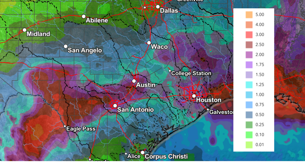
- Friday afternoon, the most favorable area for scattered showers and isolated thunderstorms is forecast to be across the coastal plains, where the probability for rain will be near 40 percent. Further inland and up to the Austin/Interstate 35 corridor, there will be a 20-30 percent for scattered rain showers and thunderstorms. The showers and not expected to make it as far inland as the Hill Country. For areas that happen to see rain, totals should average around a quarter inch, with isolated totals to near 1 inch possible.
- For Saturday and Sunday, the best chance for scattered showers will likely remain across the coastal plains region, where the probability for rain will be near 50-60 percent. Daily rain amounts will average between 0.25 and 0.5 inches, with isolated totals to near 1 inch. Across the Hill Country and Central Texas regions, the chance for rain and isolated storms will be near 20-30 percent. Spotty totals to around a quarter inch are predicted along with some isolated heavier totals.
We should see the temperature trend a little less hot through the weekend due more clouds and increased moisture.
- High temperatures Friday through Sunday are forecast to be in the mid-90s across Central Texas and in the low 90s across the Hill Country and the coastal regions
An unsettled and potentially wet weather pattern appears to be setting up next Monday through Wednesday as the center of the heat dome pulls north to the Dakotas, allowing a trough of low pressure to spread into Texas from the Mississippi Valley. A very moist atmosphere and increasing instability is expected to cause a widespread coverage of disorganized showers and thunderstorms across the region Monday and Tuesday, with a somewhat lower chance for rain and storms on Wednesday. The probability for rain across the region Monday and Tuesday will be near 60-70 percent, decreasing to 30 on Wednesday and just 20 percent on Thursday.
Forecasts are showing the potential for the development of moderate and possibly even heavy rain across the region Monday through Tuesday. Totals of 1-3 inches are predicted. However, these generous totals may not quite pan out. The reason for the concern is a dense area of Saharan dust is forecast to arrive onto the Texas coast Monday. Depending on how far inland this plume gets, it could act to suppress the development of showers and storms. As of now, I’m still leaning toward the wetter solution.
NWS Rainfall Forecast Valid through 7 pm Friday, 7/17:
- High temperatures Monday through Wednesday are forecast to generally be near 90-92 degrees.
Dry and hot weather will make a quick return late next week as the area of low pressure exits to the west and the center of the heat dome begins to shift south from the Dakotas to the southern Rockies. High temperatures are forecast to return to the mid and upper 90s.
Next weekend, continuing through the week of July 20th, dry and very hot weather is forecast as our region comes under the influence of a strong heat dome centered over New Mexico. Daily high temperatures are predicted to hold near 98-100 degrees through the period.
Tropical Weather Outlook
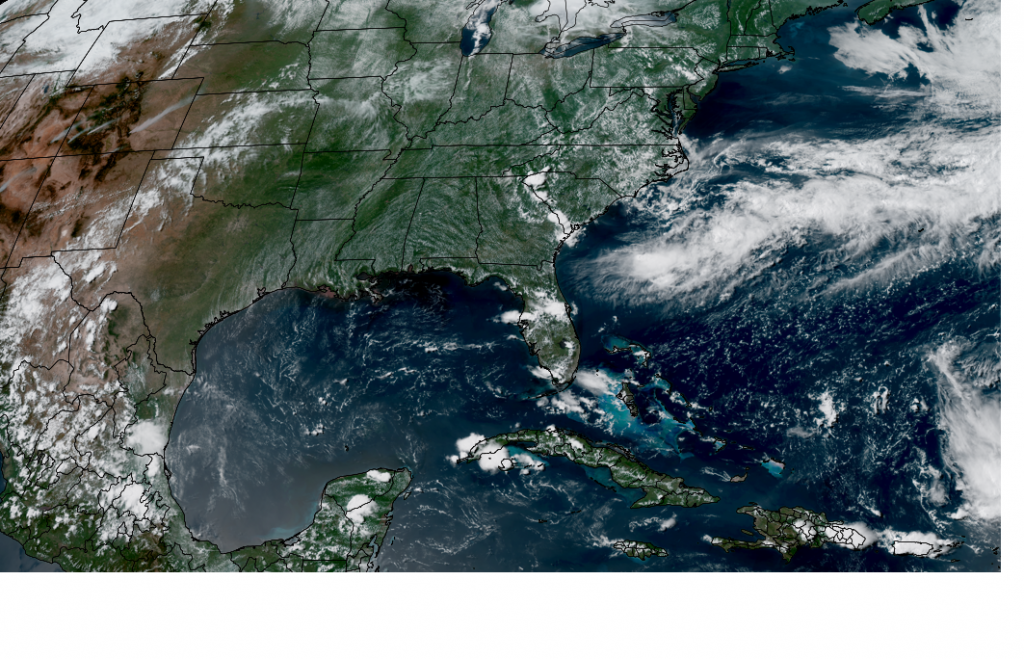
Weather conditions remain very quiet across the tropical Atlantic, the Caribbean Sea and the Gulf. Atmospheric conditions are expected to remain unfavorable for the development of tropical cyclones through the next week.
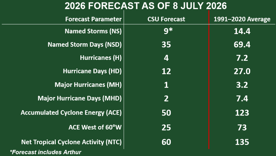
Colorado State Forecasters Further Reduce the Number of Storms Expected this Year
Phil Klotzbach and his forecast team at Colorado State University further reduced the number of tropical storms and hurricanes predicted for 2026. In an update released Wednesday, the team is now calling for a well below normal season. With a strong potential for a strong El Nino to be in place during the peak of this year’s hurricane season, high levels of wind shear are forecast to be in place which should limit the development of storms. The team is also predicting a well-below normal probability for major hurricanes to make landfall along the continental U.S. coastline.
The CSU team is now calling for 9 named storms (normal is 14), 4 hurricanes (normal is 7), and 2 major hurricanes (normal is 3).
I am going to be taking some time out of the office over the next couple of weeks. My next report will be around July 25th.
Have a great weekend!
Bob
Forecasts Shows No Break from the Heat Over the Next Couple of Weeks
Scattered thunderstorms are forecast across this Hill Country Monday afternoon into Monday evening. These storms are the result of a leftover boundary from thunderstorms which developed across Oklahoma late Sunday. This boundary spread south into Northwest Texas Sunday and was situated across the Hill Country and West Texas Monday afternoon. The probability for rain across the Hill Country through Monday evening will be near 40 percent. Some of Monday’s storms may produce strong and gusty winds along with pockets of locally heavy rain. Rain amounts are forecast to average between 0.5 and 1 inch, with isolated totals to near 2 inches possible. This same boundary may bring a few isolated showers or thunderstorms to part of Central Texas Monday afternoon, but most locations should stay dry.
Towards the coast, scattered showers and thunderstorms will be possible through early evening as the sea breeze pushes to the northwest. Spotty totals to around a quarter inch will be possible.
- High temperatures Monday are forecast to be in the upper 80s to low 90s across the western half of the Hill Country, in the mid to upper 90s across the eastern Hill Country and Central Texas regions, and in the low to mid-90s across the coastal plains
Tuesday’s weather will include a 20 percent chance for scattered thunderstorms across the Hill Country due to some remnant boundaries from Monday’s activity. The rest of the region is predicted to be mostly sunny and hot.
- High temperatures Tuesday will include the mid-90s across the Hill Country and coastal regions, and in the upper 90s across Central Texas
Wednesday through Friday, expect a pattern of mostly sunny, dry, and hot weather as our region comes under the influence of a subtropical ridge of high pressure, or heat dome. The center of the heat dome is forecast to be well to our west over southern California.
- Daily high temperatures look to continue in the mid and upper 90s
Scattered showers and thunderstorms will return to the forecast across the region this weekend and next Monday as the center of the heat dome becomes established across the central Rockies, allowing an enhanced area of moisture to spread inland from the Gulf. The probability for rain each day will be near 30-40 percent, with daily rain amounts expected to be around a quarter inch. Some isolated heavier totals will be possible.
- High temperatures Saturday through Monday are forecast to be in the mid-90s across the Hill Country and Central Texas regions, with lower 90s expected towards the coast
Next Tuesday through Friday, the heat dome is forecast to cover much of the southwestern and south-central U.S., with the center or most intense portion setting up over southern Plains. The heat dome is expected to produce a pattern of sunny, dry, and hot weather across the entire region. Look for high temperatures to be in the upper 90s at most locations. High temperatures look to climb close to 100/101 degrees across the Hill Country and Central Texas regions beginning late next week and the following weekend.
Tropical Weather Outlook
Weather conditions remain very quiet across the tropical Atlantic, the Caribbean Sea, and the Gulf. Atmospheric conditions appear unfavorable for tropical cyclone development over the next seven days.
Another Plume of Saharan Dust is Headed Toward Texas
Satellite images show another plume of Saharan dust across the Caribbean that is forecast to approach South Texas on Wednesday. The plume of dust is expected to push farther inland Thursday and is expected to be the primary driver in elevated fine particulate matter across the state, although lingering smoke associated with the burnings in Canada, Mexico, and southwestern CONUS could also play a role. Breezier winds across the eastern two thirds of the state could increase dispersion in that area. The plume of Saharan dust is forecast to linger into Friday, then slowly exit to the north.
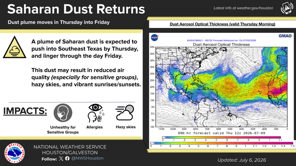
It is interesting to note there are additional plumes of Saharan dust lined up across the tropical Atlantic that are pushing to the west and could move into Texas next week.
Have a good week!
Bob
Sunny and Hot Weather Expected through Weekend. An Isolated Shower or Two will be Possible
Hot temperatures and high humidity levels will be the primary weather factors we’ll be dealing with this Fourth of July weekend. A few brief, isolated rain showers or thunderstorms will be possible–mainly across the coastal region. However, most areas are forecast to stay rain-free.
Friday’s weather maps showed a broad ridge of high pressure, or heat dome, stretching from northern Mexico to the northeastern U.S. The most intense part of the heat dome was centered over the central Appalachians and is expected to bring intense, record-breaking heat to much of the eastern U.S. through Saturday. Fortunately, Texas will be on the western, less intense edge of the heat dome through the weekend. Sinking air underneath the heat dome will help to keep quiet weather in place through the weekend.
A very weak tropical wave, or area of low pressure, is currently situated over the northwestern Gulf and southwestern Louisiana, moving slowly to the west. This feature is expected to pull an area of tropical moisture inland across Southeast Texas and will result in the development of a few scattered rain showers and isolated thunderstorms—mainly for areas along and to the south of Interstate 10 through Sunday. Here, the probability for rain at any given location each day will be around 20-30 percent and rain amounts should average less than a quarter inch. A few of the showers could drift a little further inland up to the Interstate 35 corridor, but the chance for rain will be less than 20 percent. This activity will be driven by the heat of the day and any developing showers should dissipate by sunset.
Heat and humidity will be the main talking points this weekend thanks to the proximity of the heat dome.
- Daily high temperatures through Sunday are forecast to be in the mid to upper 90s across the Hill Country and Central Texas regions, and in the lower to mid-90s across the coastal region
Figuring in the high relative humidity levels that are in place, peak index readings are forecast to be in the range of 100-105 degrees.
If you plan to spend the day outdoors this weekend, make sure you wear light cloths, apply sunscreen, and stay hydrated by drinking plenty of water. Also take plenty of breaks from the heat by seeking shade and AC.
–Next Week–
Lingering tropical moisture is expected to cause the development of more spotty, brief rain showers and isolated thunderstorms across the coastal plains and parts of Central Texas on Monday. However, this small chance for rain looks to end on Tuesday. Forecasts call for heat dome over the eastern U.S. to weaken early next week, with the heat dome relocating to the southwestern U.S. and northern Mexico. Despite the changing position of the heat dome, sunny, dry, and hot weather looks to continue throughout the week.
Daily high temperatures are predicted to be in the upper 90s, with mid-90s across the coastal plains region.
Generally dry and continued hot weather is forecast for the week of July 13th.
Tropical Weather Outlook
Weather conditions remain very quiet across the tropical Atlantic, Caribbean Sea, and the Gulf. Atmospheric conditions remain unfavorable for tropical development over the next seven days.
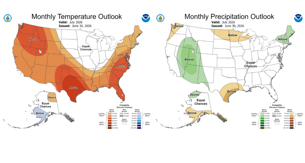
Updated Outlook for the Month of July
Earlier this week, NOAA’s Climate Prediction Center issued their first of the month updated outlook for July. The outlook shows increased odds the temperature will average above normal. For rainfall, the outlook leans toward below normal rainfall across the Hill Country, Central Texas, and coastal regions. The strengthening El Niño in combination with other atmospheric features are expected to keep the heat dome over our area throughout the month. This will result in continued hot weather and little rainfall.
I hope everyone has a safe and happy holiday weekend! Stay cool and drink plenty of water.!
Bob
The Heat Dome Will Keep Conditions Hot and Dry through the Holiday Weekend
The month of June is ending dry and quite hot! Ever since our spring wet pattern ended about ten days ago, there hasn’t even been a hint of rain around the area. Monday’s weather maps showed a broad area of high pressure in the middle and upper atmosphere, or heat dome, stretching from northern Mexico to the Great Lakes region. The dome was centered over western Tennessee. Forecasts for this week call for the heat dome to expand and cover most of the eastern U.S., causing a major, record-breaking heat wave to develop. Meanwhile across Texas, little day-to-day change in the weather is predicted through Friday as the center of the heat dome remains well to the northeast. Some late night and morning low clouds will give way to a mostly sunny sky and hot temperatures in the afternoon.
There will not be any break from the heat this week.
- High temperatures Monday afternoon through Thursday are forecast to generally be in the mid-90s across the Hill Country and Central Texas regions, and in the low to mid-90s across the coastal region
- High temperatures Friday are forecast to be in the upper 90s across the Hill Country and Central Texas regions, and in the low to mid-90s across the coastal plains
Heat indices will remain elevated due to the hot temperatures and high relative humidity levels. Expect peak afternoon readings to generally be in the range of 100-105 degrees.
Winds are expected to remain strong and gusty through Tuesday, with occasional gusts to near 25/30 mph. Wind speeds are forecast to decrease some Wednesday through Friday, with speeds staying generally in the range of 10-15 mph.
Fourth of July Weekend
Few if any changes in the weather are predicted for the holiday weekend. Mostly sunny and dry weather will continue. Expect high temperatures to remain in the upper 90s, with lows in the mid and upper 70s. Breezy conditions look to continue.
Next Week
More sunny, hot, and rain-free weather is forecast across the region throughout the week as the center of the heat dome relocates to northern New Mexico and southern Colorado. The heat dome will continue to be the main feature influencing our weather. While a couple of isolated rain showers will be possible across the coastal region each day, the remainder of the region will stay dry.
Temperature forecasts show readings staying very consistent, with highs generally in the upper 90s. A few Hill Country locations could reach 100 degrees. The coastal area will continue with low and mid-90s.
Long-range forecasts show the hot and dry pattern persisting beyond the middle of the month.
Tropical Weather Outlook
Weather conditions are currently quiet across the Gulf of Mexico, the Caribbean Sea, and the tropical Atlantic.
Offshore of the Southeastern U.S. Coast, the National Hurricane Center is monitoring an area of disorganized showers and thunderstorms associated with an area of low pressure along a stalled frontal boundary. Environmental conditions appear only marginally favorable for some tropical development over the next day or two as the system drifts southward and then westward before conditions become even less favorable for development later this week. NHC forecasters are giving this system just a 10 percent chance for tropical development over the next seven days.
NOAA/Colorado State University/CIRA 06/29/26 3:00 pm CDT
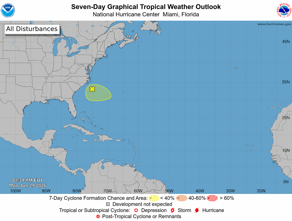
Elsewhere, tropical cyclone development is not expected over the next week.
The June Full Moon
The June full moon will occur at 6:57 pm CDT Monday evening. That’s when the lunar disk will pass opposite the sun in Earth’s sky, appearing fully lit by the sun’s rays.
This month’s full moon is also known as the “Strawberry Moon,” reflecting the time of year when Native American tribes harvest the ripened fruit. It is also the first full moon of summer, following soon after the June 21st summer solstice, which marks the astronomical start of the season and the longest day of the year.
June’s full moon tracks the lowest path of any full moon throughout the year, and that’s thanks to its proximity to the summer solstice — when the sun is at its highest in the daytime sky.
Have a great week!
Bob
The Hot and Dry Pattern Appears to be Settling in for a Long Stay
Our region remains in the grips of a hot and dry weather pattern that is showing no signs of changing anytime soon.
Friday’s weather maps showed a broad ridge of high pressure, or heat dome, covering the entire southern U.S. The ridge is currently centered over southern Mexico. This weekend into early next week, the center of the ridge is forecast to quickly shift east and set up over the Mississippi and Ohio Valleys. The heat dome is expected to bring extreme heat to parts of eastern Texas and the eastern U.S. next week. For Central and South Texas, it appears there will be little significant change in our weather or the temperatures.
Friday afternoon through late next week, the persistent heat dome looks to cause more sunny, hot, and rain-free weather. A tightened pressure gradient through the period will support breezy to occasionally windy conditions, with the strongest gusts expected during the afternoon and early evening hours. Expect southerly winds at 10-15 mph, with occasional gusts up to 25/30 mph. While the wind may provide some perceived relief from the heat at times, it will also help to keep the lower atmosphere mixed, maintain Gulf moisture, and limit overnight cooling. The mixed atmosphere will help to keep peak heat index readings generally in the range of 100-105 degrees.
- High temperatures Friday through Sunday are forecast to generally be in the mid-90s across the Hill Country and Central Texas regions, and in the low 90s across the coastal plains
- High temperatures Monday through Friday are predicted to climb to the upper 90s across the Hill Country and Central Texas region, and be in the low to mid-90s across the coastal plains
A few spotty rain showers and isolated thunderstorms will be possible across the middle Texas coast next Wednesday through Friday as moisture increases off the Gulf. The probability for rain each day will only be near 20 percent, and rain amounts should average less than a quarter inch.
The outlook for the Fourth of July weekend, calls for little change.
Looking out into the week of July 6th, forecasts call for more sunny, hot, and rain-free weather as the center of the heat dome returns to a position over New Mexico. Daily high temperatures are predicted to remain in the upper 90s, with low and mid-90s predicted across the coastal region.
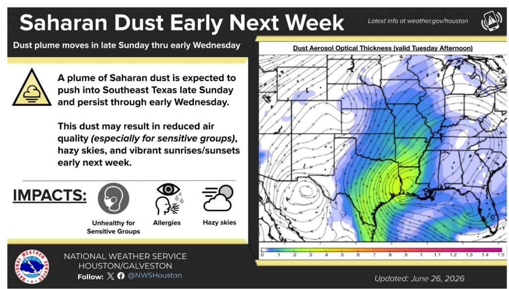
A Plume of Saharan Dust Headed for Texas
Forecasters are currently following a large plume of Saharan dust that is currently located over the Caribbean Sea. It can be seen in this visible satellite image as a brownish area stretching from just east of Belize, to Lesser Antilles.
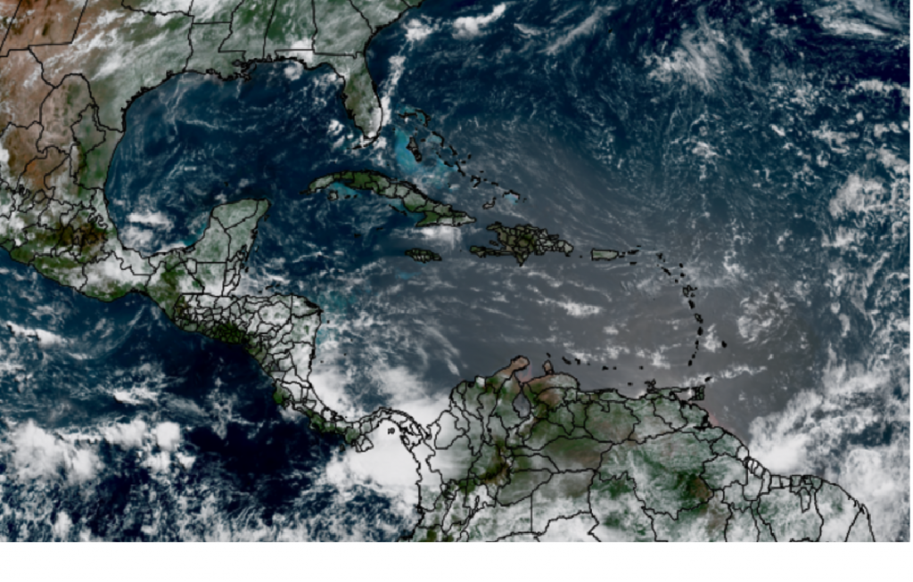
NOAA/Colorado State University/CIRA 06/26/2006 10:10 am CDT
Forecasts call for the plume of Saharan dust to turn northwest and spread north across the eastern two-thirds of Texas Monday through late Tuesday. This dust may result in reduced air quality (especially for sensitive groups), hazy skies, and vibrant sunrises/sunsets early next week.
Tropical Weather Outlook
Weather conditions remain quiet across the tropical Atlantic and tropical cyclone development is not forecast over the next seven days.
June’s Full Strawberry Moon
The June 2026 full moon, known as the Strawberry Moon, will reach peak illumination on Monday, June 29th, at 6:58 pm CDT. Look for the moon to appear quite bright and nearly full this weekend.
Have a good weekend! Remember to stay cool and hydrated!
Bob
The Summer Pattern is Setting Up. Hot and Dry Weather Expected through the End of the Month
A significant change in the weather pattern is currently taking place across Texas. The wet pattern which brought periods of soaking rain to much of our region since April and May, is quickly coming to a close. Monday’s weather maps showed a broad ridge of high pressure covering the southwestern U.S. and northern Mexico, with another broad ridge covering the Gulf of Mexico. Over the next few days, the ridge of high pressure over the southwestern U.S is forecast to spread over Texas. The strengthening ridge will likely shut off any additional cold fronts and waves of low pressure from making their way into Texas, with the storm track shifting north up to the central Plains. Summer is now definitely here across Texas! Expect temperatures to trend hotter over the next few days with little to no rain on the horizon.
Mostly sunny, hot, and humid weather will be in place this week, continuing through the upcoming weekend.
- High temperatures Monday through Wednesday are forecast to generally be in the low and mid-90s
- High temperatures Thursday through Sunday are predicted to be in the upper 90s across the Hill Country and Central Texas regions, but remain mostly in the low 90s across the coastal plains
The combination of hot temperatures and high relative humidity readings is expected to produce peak heat index readings in the range of 100-105 degrees through much of the week.
Looking ahead to next week, few changes can be expected as our region remains under the influence of the broad heat dome. Forecasts call for the center of the heat dome to set up somewhere over the Texas Panhandle or eastern New Mexico late next week. With the ridge center’s proximity getting closer, high temperatures are expected to trend even higher. Forecasts for next week call for daily high temperatures to be mostly in the upper 90s. Some triple digit temperatures will be possible—mainly across the Hill Country and Edwards Plateau regions.
Tropical Weather Outlook
Weather conditions are quiet across the tropical Atlantic and tropical cyclone development is not expected over the next seven days.
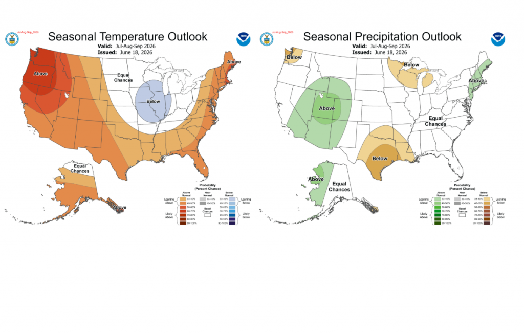
Updated Weather Outlook July through September
Last Thursday, NOAA’s Climate Prediction Center issued their monthly climate update. The updated outlook for July through September indicates the drier weather pattern we see setting up now may continue through the end of summer. The rainfall outlook leans toward below normal rainfall across all Central and South Texas. The temperature outlook leans toward above normal temperatures. The strengthening summer heat dome is expected to have a significant influence on our region’s weather, at least through August.
Have a good week. Stay cool and hydrated!
Bob
Arthur Develops. Heat Advisory Posted for Thursday
Data from radar and satellite plus information from a U.S. Air Force Hurricane Hunter Aircraft indicate there is enough convective organization to designate the system near the Texas coast as Tropical Storm Arthur—the first tropical cyclone of the 2026 Atlantic hurricane season.
Over the past couple of hours, coastal stations from Freeport to Sabine Pass have been reporting winds gusting to 35-50 mph
AS of 10 am CDT, tropical storm Arthur was centered just off the middle Texas coast, just to the east of Matagorda Bay. Arthur was moving toward the northeast near 9 mph. An increase in forward speed is expected today. On the forecast track, the tropical storm should move northeastward along the Texas coast today and then move inland over southwestern Louisiana by tonight. Surface observations and data from the Air Force Reserve Hurricane Hunters indicate maximum sustained winds have increased to near 40 mph with higher gusts. Little change in strength is expected before the center moves over land. Weakening is anticipated once the low moves inland, and Arthur could dissipate by tonight or early Thursday.
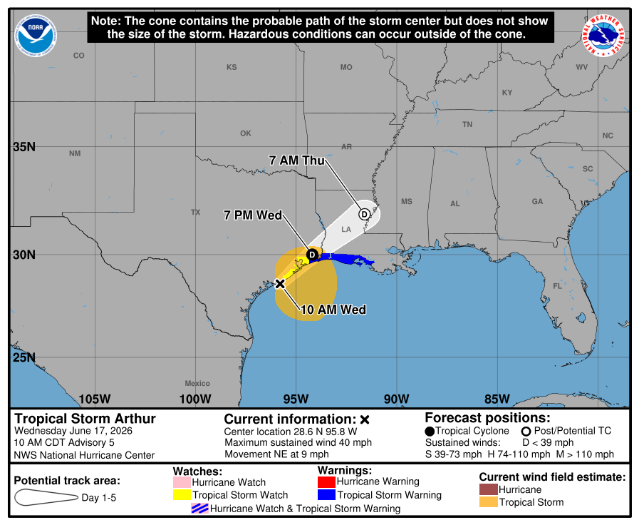
Based on the forecast track of Arthur moving toward Louisiana, the storm is not expected to impact weather conditions across the Hill Country or Central Texas regions Wednesday. Expect a mostly sunny sky with highs in the low 90s. For the middle Texas coast, there will be a 50 percent chance for scattered rain showers and isolated thunderstorms through late afternoon. Rain amounts should average less than a half inch. Expect highs in the upper 80s.
Thursday is shaping up to be a sunny and very hot day across the region as a large area of sinking air spreads in from the northwest.
- High temperatures are forecast to be near 98-100 degrees across the western Hill Country, with mid and upper 90s across the eastern Hill Country. Across Central Texas, High temperatures are predicted to be in the mid and upper 90s. The coastal region should see highs in the low and mid-90s.
A humid air mass will be in place Thursday. The combination of the very hot temperatures and high relative humidity levels is expected to bring a moderate to major heat risk to the region.
- The National Weather Service is forecasting peak afternoon heat index readings of 108-112 degrees across the Hill Country. A Heat Advisory has been posted for this area.
- The National Weather Service is forecasting peak heat index readings of 113-115 degrees across the Austin and Central Texas area. An Extreme Heat Warning has been posted for this area.
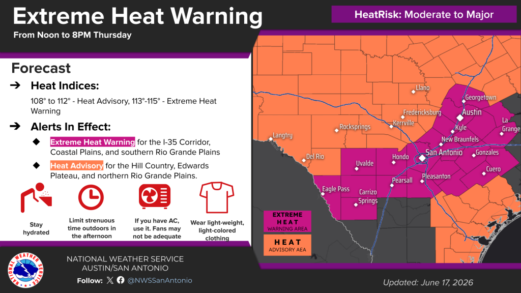
Friday is expected to be another sunny and hot day. However, temperatures and moisture levels are forecast to be a little lower and this should result in somewhat lower heat index readings. Peak heat index readings of 108-110 degrees are forecast for the Austin and Central Texas area.
Forecasts point to showers and thunderstorms developing across parts of West and Northwest Texas Thursday evening and Thursday night as a cold front sags southeast out of the Panhandle. Rain and thunderstorms are predicted to spread into the Hill Country out of West Texas late Thursday night into Friday morning. Additional showers and thunderstorms are forecast to develop across the region Friday through Saturday as the front sags a little further to the south. With a very moist air mass in place, some locally heavy rain will be possible. A slight chance for rain looks to continue into Sunday.
Bob
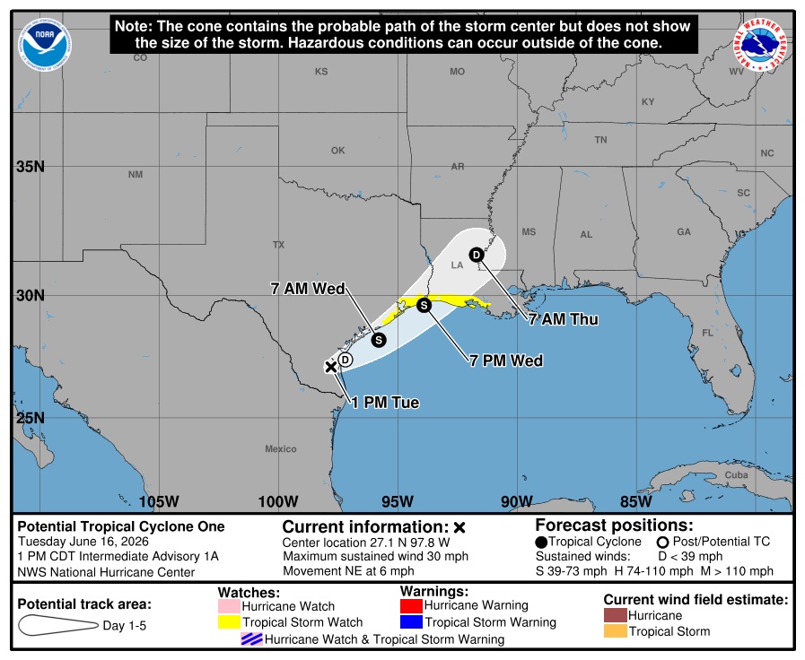
Potential Tropical Cyclone One Develops
The low pressure system that has been over northeastern Mexico for the past few days has now moved into southern Texas. While the system is producing widespread rain and thunderstorms, it still lacks a well-defined center. Most of this morning’s forecast guidance suggests it will move offshore tonight, with winds increasing to tropical-storm-force on Wednesday. With this in mind, the National Hurricane Center has begun issuing advisories on Potential Tropical Cyclone One. (A potential tropical cyclone is a weather disturbance that has not yet officially formed into a tropical depression or tropical storm but poses a threat of bringing tropical-storm or hurricane-force winds to land areas within 72 hours).
The upper-level environment is not particularly conducive for this system to intensity very much. However, there is enough support in the upper atmosphere to cause large-scale deepening, so some intensification is expected.
As of 1 pm CDT, the low pressure area was centered about 55 miles southwest of Corpus Christi. The system was moving toward the northeast near 6 mph, and this general motion with an increase in forward speed is anticipated over the next couple of days. The disturbance should move offshore the Texas coast tonight or early Wednesday, move roughly parallel to the upper Texas coast later on Wednesday, and move back inland in extreme eastern Texas or southwestern Louisiana late Wednesday or early Thursday.
- Maximum sustained winds are currently near 30 mph with higher gusts. The disturbance is forecast to gradually strengthen and could become a tropical storm early on Wednesday. Weakening is anticipated on Thursday after the system moves back on land.
- A Tropical Storm Watch has been issued for the northwestern Texas Gulf Coast from Sargent, Texas, to Morgan City, Louisiana. A Tropical Storm Watch means that tropical storm conditions are possible within the watch area, in this case, within 24 to 36 hours.
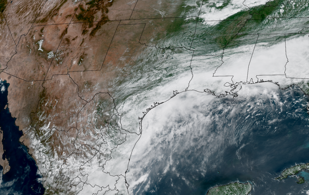
NOAA/Colorado State University/CIRA 06/16/26 12:50 pm
This system is not expected to have any direct impact on the weather across the Hill Country or the Austin/Central Texas area. While some light to moderate rain showers may spread north into the area Tuesday afternoon, rain amounts are forecast to remain below a half inch.
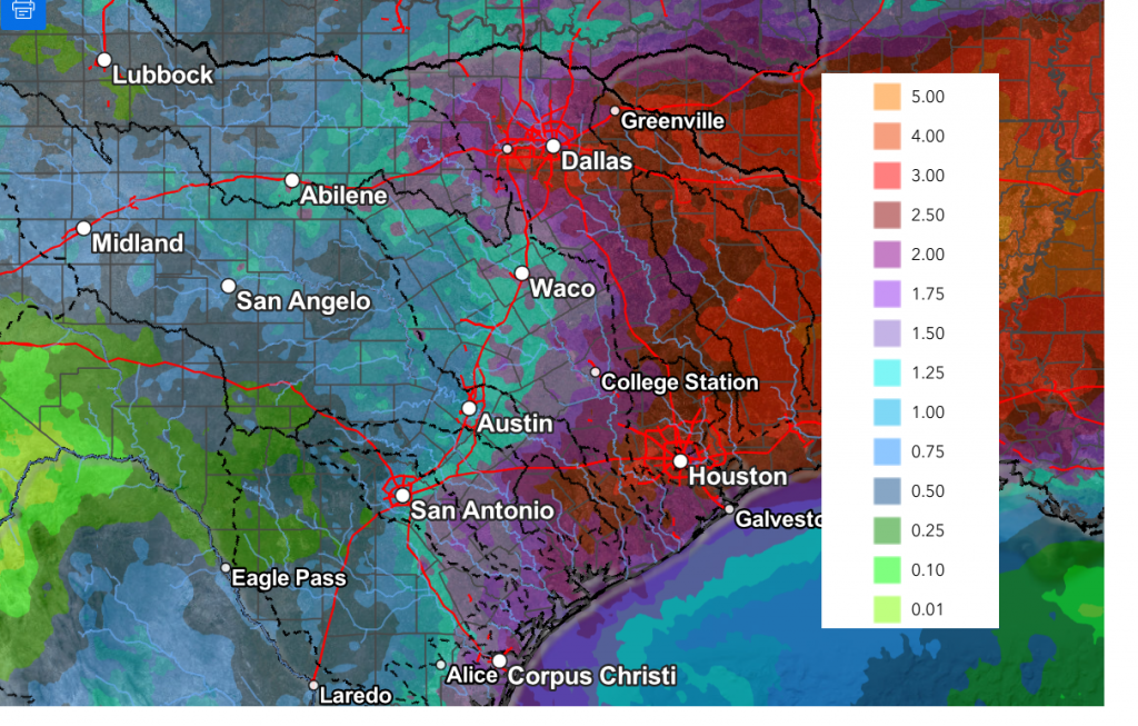
The main impacts from this system are expected to occur across the coastal region–Gonzales, Lavaca, Fayette, Washington Counties, and areas south to the coast. Periods of moderate to heavy rain are forecast across this area Tuesday through Wednesday, with the chance for rain decreasing on Thursday. A Flood Watch has been posted this region through Thursday morning. Rain amounts through Thursday are forecast to be in the range of 4-8 inches. Some isolated totals up to 12 inches will be possible towards the coast. Southerly winds with gusts to around 25/30 mph are forecast Tuesday night through Wednesday.
NWS Rainfall Forecast Valid through 7 pm Thursday:
Bob
Threat for Heavy Rain Shifting to the Coastal Plains Tuesday into Thursday
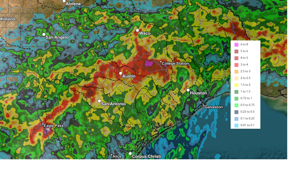
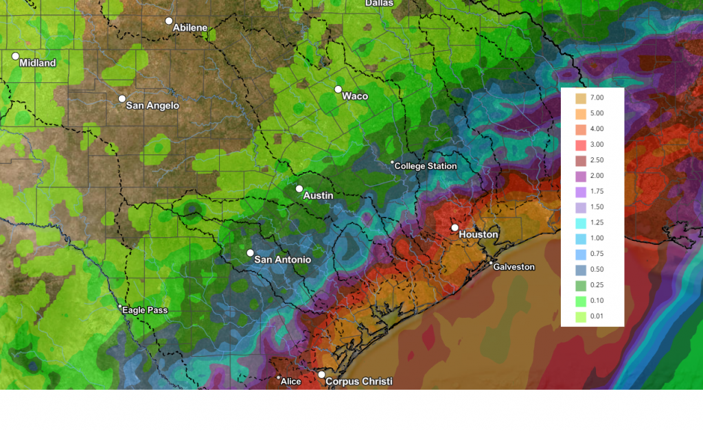
A cold front sinking slowly out of North Texas caused the development of widespread, soaking rains across Much of the Hill Country and Central Texas Sunday night into Monday morning. Rain amounts of 1-3 inches were recorded across much of the area. A zone of 3–4-inch totals stretched from northwest of San Antonio to Johnson City, and east through Austin and College Station. According to LCRA’s Hydromet, some totals more than 5 inches were recorded across parts of Blanco and Gillespie Counties.
NWS Estimate of Rain Falling Between 10 am Sunday and 10 am Monday:
As of mid-afternoon Monday, the heaviest and most widespread rain had shifted southeast of Central Texas, stretching from around San Antonio to Houston. Monday evening through Tuesday afternoon, the heaviest rains are expected to remain across the coastal plains, in the vicinity of the stalled cold front. Across Central Texas and the Hill Country regions, additional light to moderate rain and isolated thunderstorms can be expected Monday night through Tuesday.
For the Hill Country, the probability for rain will only be around 20 percent Monday night, increasing to near 40 percent on Tuesday. Rain amounts through Tuesday evening should average less than a quarter inch.
For the Austin and Central Texas area, the probability for rain Monday night is forecast to be near 40 percent Monday night and near 70 percent on Tuesday.
For the middle Texas coast, the probability for rain Monday night is forecast to be near 70 percent Monday night and near 100 percent on Tuesday and Tuesday night. Periods of heavy rain will be possible.
National Hurricane Center forecasters continue to monitor a trough of low pressure located over northeastern Mexico. This system is producing a large area of disorganized showers and thunderstorms over South Texas. Tropical development is not expected Monday night. However, the system looks like it could re-emerge over the northwestern Gulf late Tuesday or Wednesday, and environmental conditions there are marginally conducive for the formation of a short-lived tropical storm Wednesday into Thursday.
The NHC has raised the probability for tropical development up to 40 percent through Wednesday morning and near 50 percent late Wednesday into Thursday.
Regardless of tropical cyclone formation, this area of low pressure is expected to pull considerable moisture inland across the coastal plain, resulting in periods of intense rainfall Tuesday into Wednesday which could result in life-threatening flash, urban, and river flooding. In addition, gusty winds to near 30 mph and coastal flooding will also be possible along portions of the northwestern Gulf Coast.
Tropical Storm Watches or Warnings could be required on Tuesday.
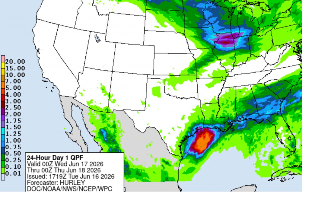
For Wednesday, most of the rain will be confined to the coastal region as the low tracks to the northeast. Partly cloudy and generally dry weather is forecast across the Hill Country and Central Texas regions. For the coastal region, showers and possible heavy rain looks to continue through the morning hours, then diminish Wednesday afternoon.
Total rain amounts through Wednesday evening are forecast to average less than a quarter inch across the Hill Country, be between 0.25 and 1 inch across the Central Texas, and average somewhere between 4 and 7 inches across the coastal plains.
NWS Rainfall Forecast Valid through 7 pm Wednesday:
Thursday is shaping up to be a mostly sunny and warm day across the region. There will be a chance for some additional scattered showers and thunderstorms across the coastal region . High temperatures are predicted to be in the low and mid-90s.
A chance for showers and scattered thunderstorms is forecast across the region Friday through Saturday as another weak cold front slides south and stalls somewhere across Central Texas. Forecast rain amounts look to be between 1 and 2 inches. Expect warm and humid conditions with daily highs in the low 90s.
The outlook for next week calls for mostly sunny, dry, and hot weather. Expect daytime high temperatures to be in the mid-90s.
Have a great week!
Bob
Showers and Storms Increasing Late Sunday. Keeping an Eye on Developments in the SW Gulf
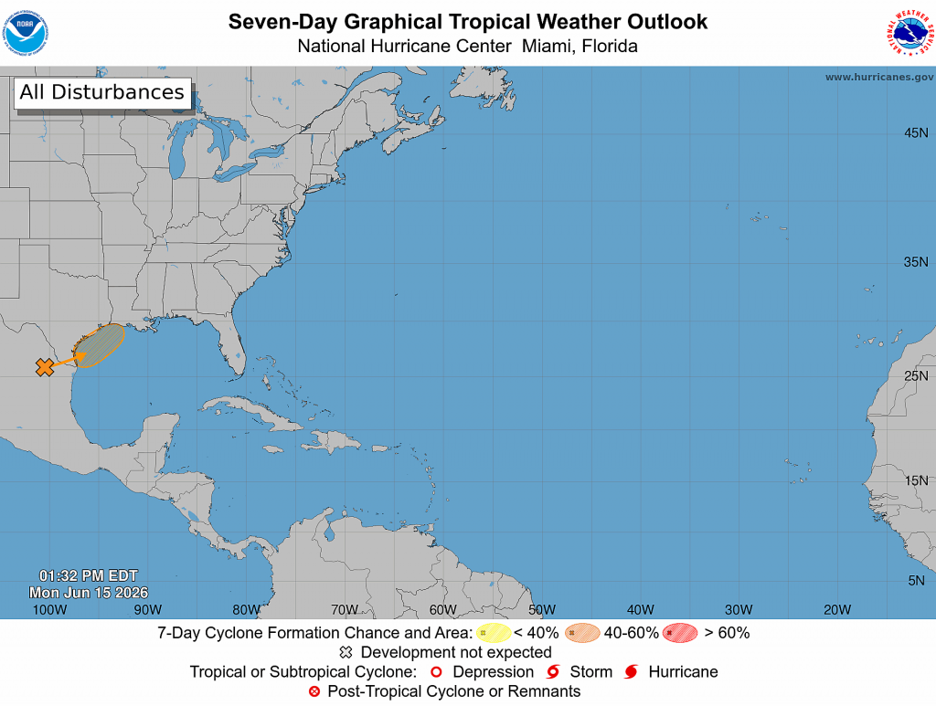
Starting off today’s brief with a look at weather conditions in the Bay of Campeche as conditions there may have some influence on Texas weather early next week.
National Hurricane Center forecasters are indicating a broad area of low pressure has formed over the far southern Bay of Campeche and the low is producing an area of disorganized showers and thunderstorms. Satellite images show a burst of deep convection has developed, but there are no indications a surface low pressure area developing. Environmental conditions are only marginally favorable for any development of this system given a good amount of westerly and southwesterly wind shear in place over the southern and western Gulf. NHC forecasters call for the system to move inland over eastern Mexico sometime late Saturday or Sunday. Given the marginal conditions in place, the probability for tropical development will only be 20 percent over the next few days.
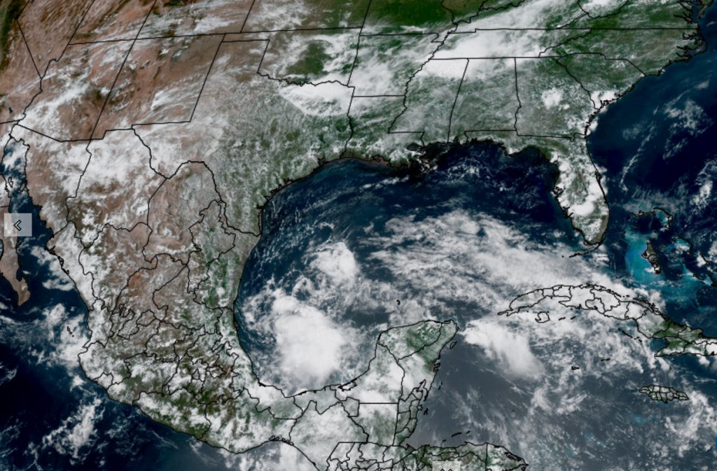
NOAA/Colorado State University/CIRA 06-12/26 12:50 pm CDT
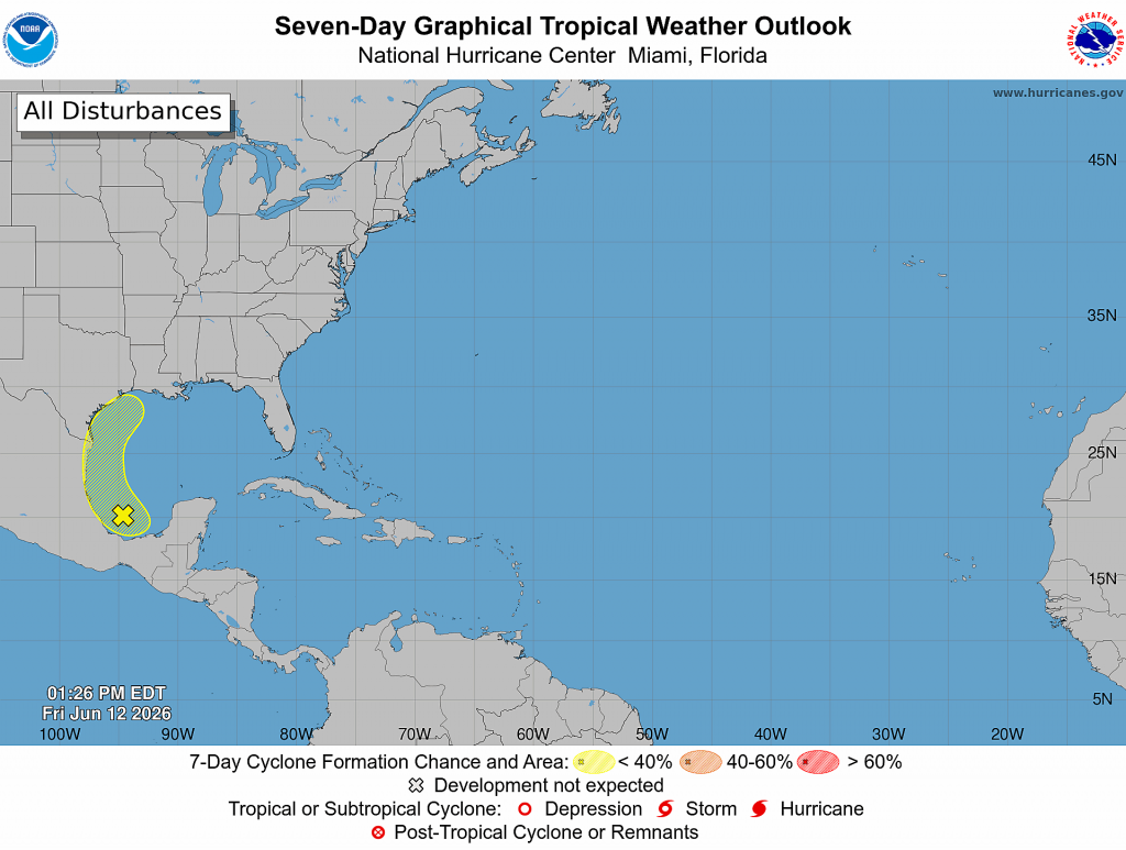
NHC points out the system could re-emerge over the northwestern Gulf on Tuesday and Wednesday while interacting with a frontal boundary. Because of this, the formation area (drawn in yellow on the outlook map above) extends north along the Texas coast. If the system does happen to re-emerge off the Texas coast early next week, conditions are expected to be only marginally conducive for tropical development.
Tropical moisture associated with this system is forecast to spread northwest toward the northern Mexican and southern Texas coasts over the weekend, then spread north along the Texas coast early next week. This enhanced area of moisture interacting with a cold front may help to produce heavy rainfall—especially across the coastal region.
Friday Afternoon through Sunday Afternoon
Partly cloudy and very summer-like weather is forecast Friday afternoon through Sunday afternoon as our region remains under a broad ridge of high pressure in the middle and upper atmosphere. High temperatures each day will generally be in the low 90s. Unusually high relative humidity levels will combine with the warm temperatures to produce peak heat index values of 100-105 degrees.
With considerable moisture in place, an isolated rain shower or thunderstorm will be possible on Friday and Saturday. The chance for rain at any given location will be less than 20 percent. Rain amounts, if any, should total less than a quarter inch.
Sunday Afternoon through Wednesday
The weather pattern will be changing late Sunday as the ridge of high pressure over Texas shifts southeast while a broad trough of low pressure develops south through the Plains states. This will allow for a rather strong cold front by mid-June standards to press south into Texas. Forecasts call for the front to reach the Interstate 20 corridor over North Texas Sunday afternoon and Sunday evening. The front is predicted to sink south across Central Texas late Sunday night into Monday morning and stall somewhere near Interstate 10 Monday afternoon and Monday evening.
Forecast guidance suggests a widespread area of rain showers and thunderstorms will develop ahead of and along the cold front as it sinks south through the region. The highest probability for rain and storms across Central Texas looks to be Sunday night through Monday. For the coastal region, the highest probability for rain will occur Monday through Tuesday.
Generally speaking, the probability for rain Sunday afternoon will be 40-50 percent, increasing to 60-70 percent Sunday night. The probability for rain Monday and Monday night will be near 80-90 percent, decreasing to 40-50 percent on Tuesday.
The threat for severe storms through this period will be low. Meanwhile, with abundant moisture in place, the threat for moderate to heavy rain and possible localized flash flooding will ramp up late Sunday and continue into early next week. The threat for heavy rain should taper off across the Hill Country and Central Texas regions Tuesday morning and across the coastal region Tuesday night.
Rain amounts through Wednesday morning are forecast to generally average between 1 and 3 inches. Should that enhanced area of moisture from the tropical wave spread north up along the Texas coast, isolated total to near 5 inches will be possible—especially across the coastal plains region.
NWS Rainfall Forecast Valid through 7 pm Wednesday:
The outlook for late next week and next weekend is somewhat uncertain. Some of the forecast solutions indicate we could see another surge of tropical moisture into Texas late next week, while others are showing a return of the heat ridge. I’m leaning towards the drier and hot solution at this time, but conditions could change. Stay tuned.
Colorado State/ Phil Klotzbach Updated Hurricane Season Forecast
Thursday, Dr. Phil Klotzbach and his forecast team at Colorado State University issued an update to their seasonal hurricane season forecast. The update trimmed the number of storms that had been forecast in their April Outlook. The team now expects 11 named storms, five hurricanes, and two major hurricanes. This is down from their earlier prediction of 13 named storms and 6 hurricanes.
The primary reason for the downgrade is the development of El Niño conditions now and through the heart of hurricane season. El Niño tends to strengthen upper-level winds across the Caribbean and tropical Atlantic, increasing vertical wind shear that can disrupt developing tropical systems. The forecast team also noted that sea surface temperatures in portions of the eastern and central tropical Atlantic are running cooler than average, further reducing the odds of an especially active season.
The researchers are also forecasting a below-average probability of major hurricane landfalls in the United States and Caribbean. But they remind residents that preparedness remains essential because one storm can define an entire season for a community in its path.
Have a great weekend!
Bob
Social Media