Warm through Wednesday. A Cold Front Bringing an Increasing Chance for Rain Thursday
NOV. 6, 2023
The weather trended warmer and bit more humid over the weekend as southerly breezes strengthened off the Gulf of Mexico. A stable ridge of high pressure in the upper atmosphere situated over south central Texas continues to keep the weather pattern dry and quiet. With increased moisture in place, expect widespread low clouds and patchy fog across Central Texas and the coastal plains regions Monday, Tuesday, and Wednesday nights. A stream of middle and high level clouds spreading northeast from Mexico and across Texas will cause a mostly sunny to partly cloudy sky in the late mornings and afternoon.
The temperature will be trending warmer today through Wednesday. Expect high temperatures in the low 80s Monday, and in the mid-80s Tuesday and Wednesday. Lows through Thursday morning will range from the low 60s across the Hill Country to the upper 60s across the coastal plains.
A change in the weather is forecast to take place Thursday when a cold front pushes south across the region. The front is predicted to reach the northern Hill Country around sunrise, push south and move off the coast by about sunset. With abundant Gulf moisture in place, forcing along the cold front is forecast to cause the development of widespread rain showers and a few isolated thunderstorms Thursday into Thursday night. Lighter overrunning rains look to continue into Friday morning, with the rain tapering by Friday afternoon. In this particular event, the most favorable area for rain is expected to be for areas along and east of Interstate 35, where moderate to heavy rain is forecast. Training rain showers and abundant Gulf moisture may lead to some large totals of rain.
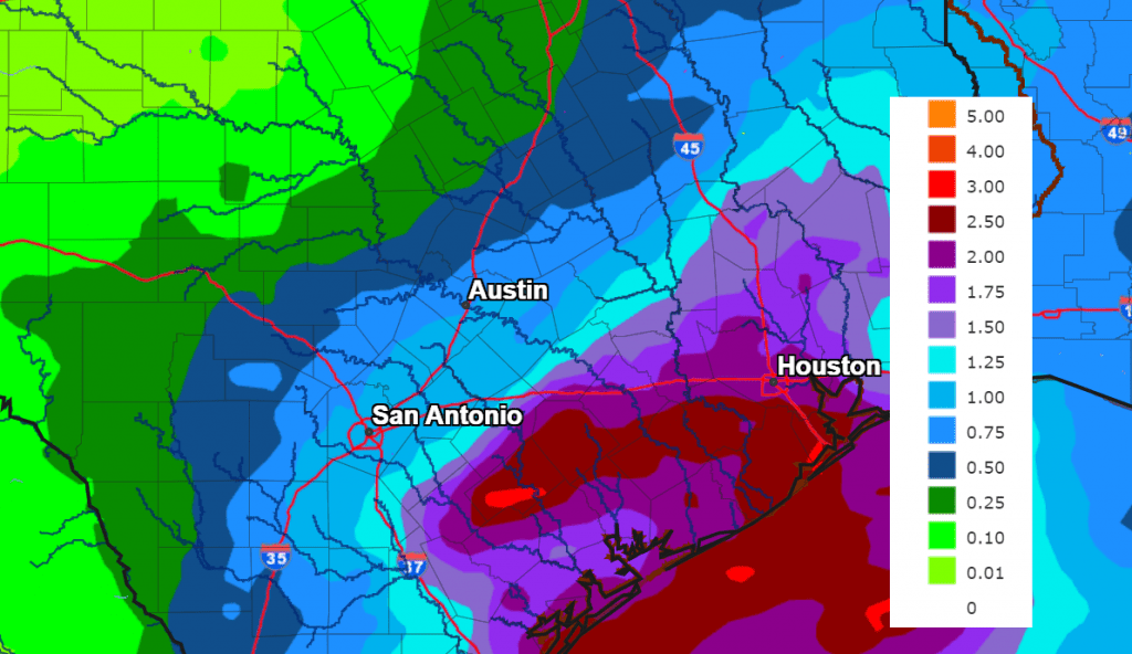
The National Weather Service’s rainfall forecast calls for widespread totals of 2-2.5 inches across Colorado, Wharton, and Matagorda Counties. Across Central Texas, totals are forecast to average between 0.75 and 1.25 inches. For areas west of Interstate 35, totals are forecast to average between 0.25 and 0.75 inches.
NWS Rainfall Forecast for the Period 6 pm Monday through 6 pm Saturday:
Dry weather is forecast Friday night through Saturday night. Another chance for mainly light rain is predicted to develop Sunday into Sunday night when a weak trough of low pressure tracking northeast out of Mexico causes periods of overrunning rains. The probability for rain will be near 50 percent, while rain amounts should total less than a quarter inch.
Cooler temperatures are forecast to take hold behind Thursday’s cold front, with readings falling through the 60s in the afternoon. High temperatures Friday through Sunday are predicted to generally be in the mid-60s. Lows Friday through Monday morning will range from the mid and upper 40s across the Hill Country, and in the low and mid-50s at most other locations.
Looking ahead to next week, forecasts are pointing to another chance for light rain developing next Tuesday into Wednesday. Rain amounts are predicted to remain below a quarter inch. Dry weather is forecast next Thursday and Friday. High temperatures are forecast to be in the 60s the first half of the week, warming to the 70s the latter part of the week.
Tropical Weather Outlook
Weather conditions are quiet across the entire Atlantic basin. The area of disturbed weather which had developed across the southern Caribbean Sea late last week dissipated over the weekend.
Tropical cyclone development is not forecast for the next seven days.
Have a good week!
Bob
Social Media