It’s been a very hot and summer-like week, with daily temperatures reaching close to 100 degrees at most locations. This late season heatwave is being generated by the summer heat dome, which still has not backed down or weakened significantly from August. Thursday’s analysis showed the heat dome stretching from southern Mexico to northern Texas. Forecasts call for the heat dome to remain over Texas through the weekend, causing high temperatures to stay at July-like levels. The heat dome is predicted to shift to our southwest during the early and middle parts of next week, allowing the temperature to trend down about 5 to 8 degrees.
For today through Saturday, expect a mostly sunny sky and hot temperatures. Daily high temperatures are predicted to be in the mid and upper 90s, with a few spots peaking at 100 degrees. No rain is forecast for the Hill Country and Central Texas regions, but there will be a slight chance for a few spotty rain showers and thunderstorms across the coastal plains region each afternoon as the sea breeze pushes inland off the Gulf. The probability for rain will only be 20 percent and rain amounts should total less than a quarter inch.
Changes in the weather pattern are forecast to take place beginning Sunday afternoon and evening when the heat dome starts to shift to the southwest. At the same time, a trough of low pressure pushing east out of the northern Rockies will help push a weak Pacific cold front south into Texas. Forecasts call for the cold front to reach northwest Texas Sunday afternoon,, then slowly sag south into the northern Hill Country Sunday night. The front is predicted to pull up stationary somewhere across the northern Hill Country and the northern counties of Central Texas regions on Monday. A moist and somewhat unstable atmosphere situated south of the cold front looks to be favorable for the development of scattered rain showers and thunderstorms Monday through Tuesday.
Sunday’s weather is shaping up to be mostly sunny to partly cloudy across the region. There will be a 30 percent chance for scattered rain showers and thunderstorms across the northern and western Hill Country in advance of the cold front Sunday afternoon, while most other areas will remain dry. High temperatures will continue in the upper 90s.
Sunday evening and Sunday night, the chance for rain and thunderstorms will increase to 50 percent across the western and northern Hill Country. Meanwhile, there will also be a 20-30 percent chance for scattered rain showers and isolated thunderstorms across the Hill Country and Central Texas regions. Rain amounts are forecast to remain well below a half inch.
Monday through Monday night, the probability for rain showers and thunderstorms will be near 50 percent across the region. While heavy rain is not forecast, a couple of heavy downpours will be possible from some of the stronger storms. Rain amounts Monday through Monday night are predicted to average between 0.25 and 0.5 inches, with isolated totals to near 1 inch possible. Expect a partly to mostly cloudy sky Monday, with high temperatures in the mid-90s.
There will be a 30-40 percent chance for more scattered rain showers and thunderstorms across the region Tuesday as the front remains stalled across north central Texas. Rain amounts are predicted to average between 0.25 and 0.5 inches, along with a few isolated heavier downpours. Expect a partly cloudy sky, with high temperatures in the low and mid-90s.
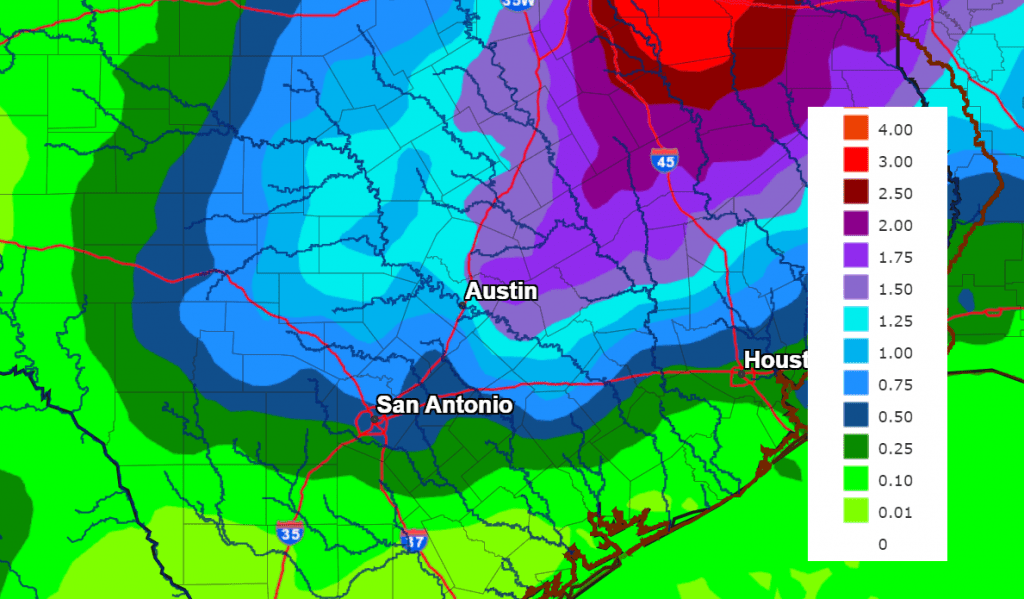
Total rainfall through next Tuesday is predicted to be average between 0.5 and 1 inch across the Hill Country and Central Texas regions. Isolated heavier totals will be possible. For areas south of Highway 59, totals are forecast to be less than a quarter inch.
NWS Rainfall Forecast for the Period 7 pm Thursday through 7 pm Tuesday:
Just a slight chance for scattered rain showers is forecast for next Wednesday as the atmosphere begins trending drier and more stable as the heat dome returns. Expect a high temperature in the low and mid-90s.
Next Thursday, continuing through next week, weather conditions are forecast to be mostly sunny, dry, and warm as the heat dome sets up across the western half of Texas and the Desert Southwest. Daily high temperatures are forecast to continue in the low and mid-90s.
Unfortunately, there still are no signs of that first strong cold front of autumn. Long-range forecasts call for high temperatures in the low and mid-90s to continue through the first week of October.
Tropical Weather Update
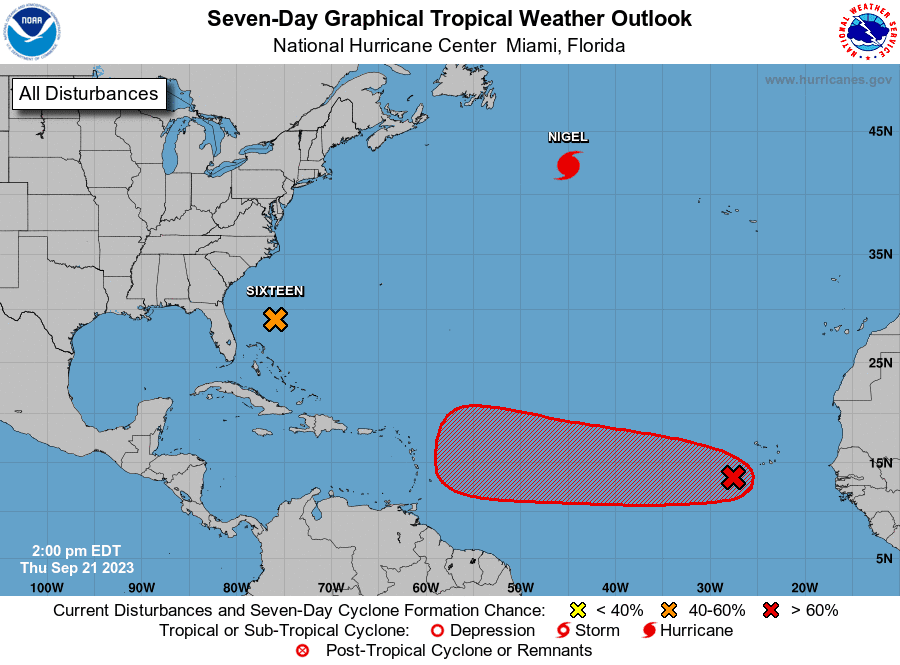
Weather conditions across the Gulf of Mexico and the Caribbean Sea are quiet and there are no systems in place which pose a threat for tropical development over the next seven days.
In the southwestern Atlantic, a broad non-tropical area of low pressure formed this morning well east of the east coast of Florida. Although this system is forecast to remain non-tropical during the next 12-24 hours, the dynamical model guidance indicates that it will likely acquire tropical characteristics late Friday and early Saturday as it approaches the coast of North Carolina. Although it is unclear as to whether the cyclone detaches from a front that is forecast to extend northeastward from the center, the guidance suggests a tropical-cyclone like core and structure when it nears the coast.
As a result, advisories have been initiated on Potential Tropical Cyclone Sixteen.
As of 10 am CDT, low pressure system was centered about 370 miles southeast of Charleston, South Carolina. The system was moving toward the north near 9 mph, and this general motion is expected to continue through early Friday. A north-northwestward to northward motion is forecast by late Friday and continue into the weekend. On the forecast track, the center of the cyclone is expected to approach the coast of North Carolina area Friday night and early Saturday. Maximum sustained winds are near 35 mph with higher gusts. Strengthening is expected during the next day or two, and the system is forecast to become a tropical storm as it approaches the coast of North Carolina.
Out in the eastern tropical Atlantic, a tropical wave is located just west of the Cabo Verde Islands and producing some disorganized shower and thunderstorm activity. Environmental conditions are forecast to be conducive for gradual development of this system, and a tropical depression is likely to form this weekend or early next week while the system moves generally westward at 10 to 15 mph across the eastern and central tropical Atlantic.
Autumn Begins Saturday
The September equinox happens at 1:50 a.m. CDT on Saturday, September 23, 2023.
On the equinox, the sun rises due east and sets due west no matter where you live on the planet (except at the north and south poles). This fact makes the day of the equinox a good day for finding east and west from your yard or favorite site for watching the sky. Just go outside around sunset or sunrise and notice the location of the sun on the horizon with respect to familiar landmarks. Our ancestors may not have understood the equinoxes and solstices as events that occur during Earth’s yearly orbit around the sun. But if they were observant – and some were very observant indeed – they surely marked the day of the equinox as being midway between the sun’s lowest path across the sky in winter and highest path across the sky in summer.
Bob
Social Media