The much anticipated rain is set to arrive early Friday, with the rain then persisting throughout much of the day. Unfortunately, the forecast for significant totals of rain has decreased.
A large area of low pressure currently located over the Four Corners region is forecast to moving to the east-northeast Thursday night into Friday. The trough is expected to draw moisture north from the Gulf of Mexico into West Texas Thursday night, followed by increasing moisture across the rest of the state Friday through Friday afternoon. With the arrival of atmospheric lift late Thursday night, a large area of light to moderate rain showers is predicted to develop across West Texas. The area of rain will then spread to the east.
Forecasts call for the bulk of the rain from this system to occur during the day on Friday. High resolution forecasts call for the area of rain to reach the Hill Country after 3 am and move into the Austin/Intestate 35 corridor between about 6 am and 10 am Friday morning. The area of rain is forecast to reach the coastal region by about midday Friday. Light rain is expected for most of the day Friday, with the rain then tapering off from west to east late Friday afternoon through late Friday evening.
A few isolated thunderstorms will be possible with the rain Friday, but conditions will not be favorable to support any strong or severe storms. All of the rain is expected to be out of the area by midnight Friday night.
Forecasted rain amounts from Friday’s weather system have decreased from earlier predictions. The heaviest rains are now forecast to occur over East and Southeast Texas. The trough of low pressure over the Four Corners will be tracking too far to the north to produce anything more than a steady light to moderate rain across our region.
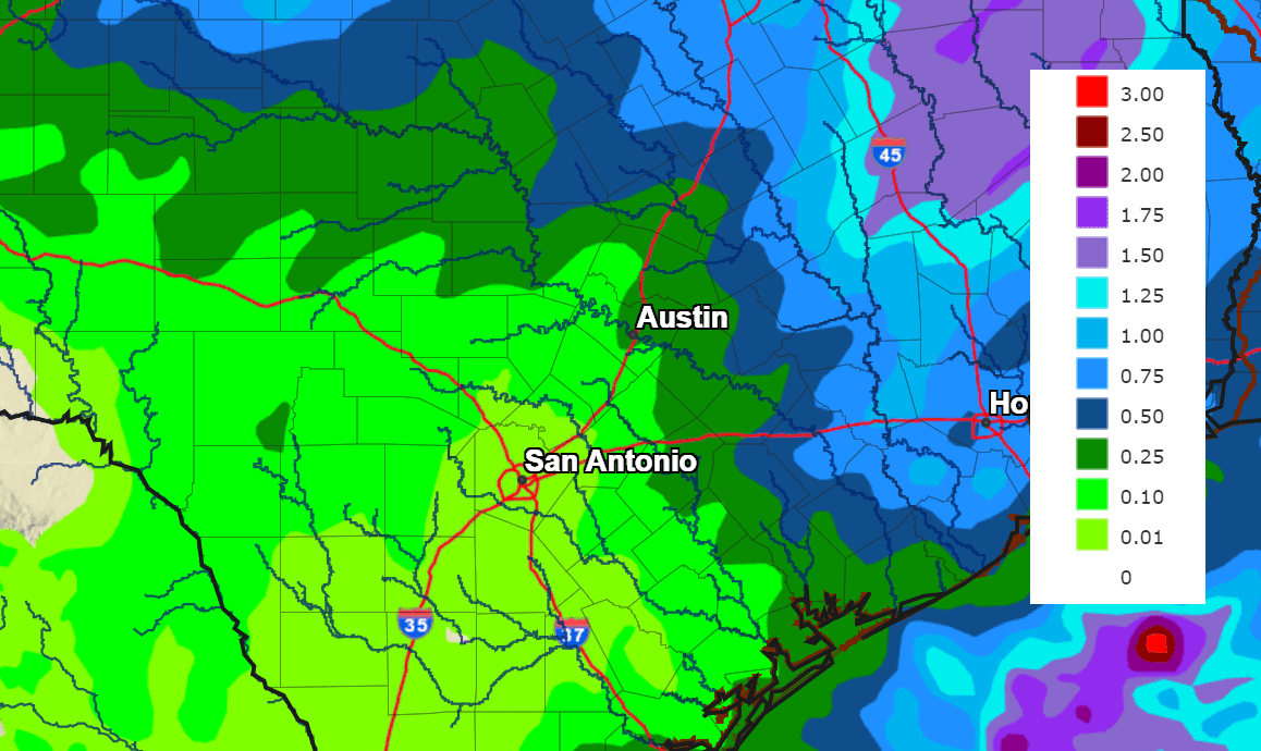
The highest rain amounts are expected to occur across the northern Hill Country and the middle Texas coast, where totals of 0.75 to 1 inch are forecast. Elsewhere, rain amounts are forecast to average close to a half inch. Totals across the southern half of Hill Country are forecast to average around a quarter inch or less.
NWS Rainfall Forecast for the Period 6 pm Thursday through 6 pm Saturday:
A sunny and dry weather pattern will take hold Saturday and continue through late next week as a stable ridge of high pressure sets up across Texas. Temperatures look to stay mild over the upcoming week, with highs in the 60s and lows in the upper 30s to low 40s.
Long-range solutions indicate the next chance for rain for our area will take place next weekend when a Pacific storm system moves into the Desert Southwest. This system does not look to have any significantly colder air with it. The period around Christmas is looking mild, with highs in the 60s.
Bob
Social Media