My Saturday update on the outbreak of arctic air:
Key Messages
- Cold, arctic air will arrive Saturday night
- Very cold conditions will be in place into the middle of the week
- The coldest nights will be Monday and Tuesday nights
- Dangerously cold wind chills into the single digits and teens forecast Sunday through Tuesday
- There will be a 20-40% chance for light freezing rain from Sunday evening through late morning Monday
- Minor ice accumulations, mainly on elevated bridges and surfaces, will be the main threat should freezing rain occur
- Preparations for the cold should be completed today
Discussion
The much anticipated arctic cold front is still on track to move through the area Saturday night. As of late Saturday morning, the cold front stretched from Oklahoma City to just north of Lubbock. Forecasts call for the front to reach the northern Hill Country late this evening, the Austin area around midnight, and the coastal area well before sunrise Sunday. Behind the cold front, temperatures will quickly tumble several degrees. Readings will be well below freezing across the Hill Country and Central Texas regions Sunday morning. Little warming is expected during the day on Sunday.
- Lows Sunday morning are forecast to be near 20 degrees across the Hill Country, in the low to mid-20s across Central Texas, and in the low to mid-30s across the coastal plains.
- High temperatures Sunday are forecast to only be around 30 degrees across the Hill Country, into the low 30s across Central Texas, and into the low to mid-40s across the coastal plains.
Saturday’s model data isn’t indicating much change in the temperature forecast Monday through Wednesday. The coldest periods are still expected to occur Monday night into Tuesday morning and Tuesday night into Wednesday morning. The Hill Country and the northern counties of Central Texas look to stay below freezing between Sunday morning and about midday Wednesday. The arctic air is still predicted to move out Wednesday night, with milder readings expected Wednesday night through Thursday (See the temperature section below). Breezy northerly winds with gusts up to 30 mph will begin Sunday and continue through Tuesday. The combination of the strong wind and very cold temperatures will create dangerous wind chill readings across the area Sunday through Tuesday. Locations in the Hill Country and Central Texas may see wind chills as low as the single digits and zero.
Confidence in the development of light overrunning precipitation continues to increase. Forecasts call for a weak trough of low pressure to push east out west Texas Sunday night, causing an overrunning pattern of clouds and light precipitation across much of the area. Very light precipitation is forecast to begin as early as late Sunday afternoon across the Edwards Plateau and western Hill Country, then expand east to cover the Hill Country and Central Texas regions Sunday evening and Sunday night and the coastal region early Monday morning. With surface temperatures below freezing, the precipitation will be in the form of very light freezing rain and some occasional sleet pellets. The wintery precipitation is predicted to end from west to east Monday morning as the overrunning pattern comes diminishes.
The forecast for the quantity of precipitation over this period has stayed about the same, with amounts expected to remain under a tenth of an inch. Even though accumulations are expected to be relatively light, cold temperatures will allow any wintry precipitation to stick to whatever it comes in contact with. The light freezing rain may cause minor ice accumulations, mainly on elevated bridges and surfaces, and this may cause hazardous travel at some locations.
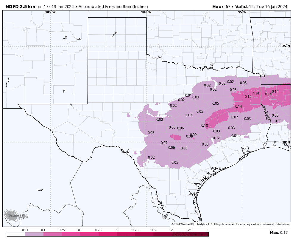
The following chart from the National Weather Service shows the areal extend and quantity of freezing precipitation forecast through 6 pm Monday:
The sky is forecast to be mostly cloudy Monday through Monday night. Clouds look to clear early Tuesday and remain mostly clear through Wednesday. The arctic air will shift east of our area Wednesday into Wednesday night.
Temperatures
- Low temperature Monday morning will include the upper teens across the Hill Country, the low and mid-20s across Central Texas, and the low 30s across the coastal plains.
- High temperatures Monday are forecast to be in the upper 20s Hill Country, the low 30s across Central Texas, with mid-30s across the coastal plains.
- Low temperatures Tuesday morning are predicted to be around 10 degrees across the Hill Country. Across Central Texas, lows will range from the mid teens in the Austin area, to near 20 degrees at La Grange. Coastal counties will see also lows around 20 degrees.
- High temperatures Tuesday are forecast to be near 28-30 degrees across the Hill Country, and in the low 30s across Central Texas and the middle Texas coast.
- Lows Wednesday morning are forecast to be between 10 and 15 degrees across the Hill Country, and between 15 and 20 degrees across Central Texas and the coastal plains.
- High temperatures Wednesday are predicted to be in the mid and upper 40s.
- Lows Thursday morning will range from the low 30s west, to the low 40s near the coast.
The opportunity to complete cold weather preparations is closing. Proper protection and winterization efforts will help to mitigate damages from the cold weather. These preparations will need to be completed by Saturday evening.

Bob
Social Media