My Tuesday update on the arctic air in place across the area.
Key Messages
- The threat for wintery precipitation has ended
- Very cold temperatures will continue this afternoon through Wednesday morning
- Temperatures look to warm above freezing by midday Wednesday
- An arctic cold front is forecast to sweep through our area Thursday night, bringing colder air for Friday and the weekend
- No precipitation is forecast along or behind the front
- Temperatures are predicted to fall to the low and mid-20s Friday night
- Weekend temperature will include highs in the 40s and lows in the 30s
- Next week’s weather will feature warmer temperatures along with good chances for rain
Discussion
Sunny weather has returned to our region in the wake of Monday’s spell of wintery precipitation. The day started off bitterly cold with widespread temperatures in the teens and wind chills in the low single digits. Despite the abundant sunshine, today’s temperature will remain cold and generally below freezing, with highs right around 32 degrees. Brisk northerly breezes will continue in the range of 10-15 mph, keeping wind chill indices in the teens.
Another very cold night is forecast Tuesday night into early Wednesday morning. The center of the arctic high pressure system is predicted to be nearly overhead heading into Tuesday evening, which should result in nearly calm winds overnight.
- Lows Wednesday morning are forecast to be near 12-15 degrees across both the Hill Country and Central Texas regions, and in the upper teens to low 20s across the coastal plains.
The weather will be sunny and warmer Wednesday afternoon through Thursday as southerly breezes return to the area. Highs Wednesday are forecast to be near 48-50 degrees. Lows Thursday morning are predicted to be in the low and mid-30s. Temperatures on Thursday will climb to the upper 60s.
Forecasters continue to track the next arctic cold font. The front is predicted to push across the area Thursday evening and Thursday night, bringing a return of colder temperatures and breezy north winds. Lows Friday morning will include the upper 20s across the Hill Country, the low 30s across Central Texas, and the mid to upper 30s for the coastal area. Friday’s weather looks sunny with high temperatures in the mid-40s.
- Friday night is shaping up to be quite cold with a hard freeze at most locations. Lows Saturday morning are forecast to be near 20 degrees across the Hill Country, in the low 20s across Central Texas, and the mid and upper 20s across the coastal plains.
A sunny sky is forecast Saturday. However, the sky is expected to become cloudy to mostly cloudy Saturday night through Sunday. Arctic high pressure will shift east of the region beginning Saturday night, bringing a return of southerly breezes and warmer temperatures.
- High temperatures Saturday are forecast to be in the low and mid-40s.
- Low temperatures Sunday morning are predicted to be in the low and mid-30s.
- High temperatures Sunday will be in the mid and upper 40s.
- Near-steady temperatures are forecast Sunday night.
Next week’s weather is shaping up to be considerably milder, with a trend toward wet weather. Forecasts call for a series of Pacific low pressure troughs to begin moving across Texas as early as late Sunday and Monday. Periods of rain showers and scattered thunderstorms are forecast from Sunday night through late next week. Significant totals of rain will be possible over the upcoming period.
NWS Rainfall Forecast for the Period Valid through 6 pm Tuesday, January 24th:
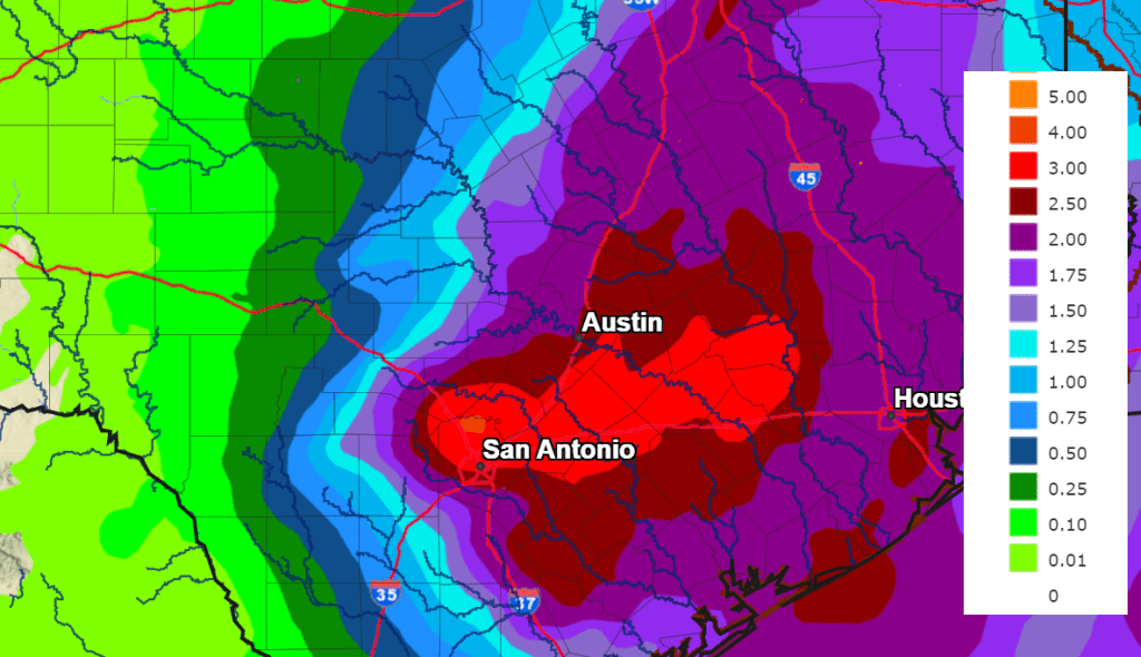
High temperatures next week look to be in the 60s, with lows in the 40s and 50s.
Bob
Social Media