The center of Tropical Storm Harold made landfall on Padre Island, adjacent to Kenedy County around 10 am Tuesday morning. Maximum sustained winds were near 50 mph with higher gusts at the time of landfall. Steady weakening is now forecast, and Harold is expected to become a tropical depression later today. Harold is moving toward the west-northwest near 21 mph and this motion is expected to continue, taking the system inland over southern Texas and northern Mexico this afternoon. The clouds and moisture associated with Harold are forecast to spread west-northwest into Mexico tonight and Wednesday. Harold’s remnants are not expected to have any impact on Central Texas or Hill Country weather on Wednesday.
Earlier this morning, a wind gusts to 44 mph was observed at Palacios. A gust to 63 mph was recorded at the Corpus Christi Naval Air Station. The Corpus Christi Airport recorded a gust to 54 mph.
As of late Tuesday morning, Doppler radar showed widespread rain and thunderstorms covering Deep South Texas, generally south of a line from around Victoria, to Pleasanton, to Eagle Pass. Scattered rain showers and isolated thunderstorms were noted across the middle and upper Texas coast, extending inland to near Interstate 10.
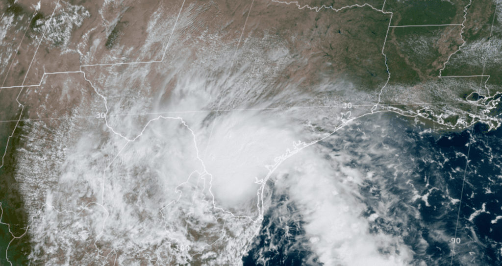
NOAA/Colorado State University/RAMMB 08/22/2023 12:20 pm CDT
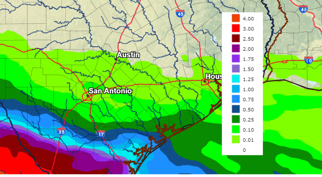
The circulation around Harold is expected to pull a limited amount of tropical moisture inland to parts of Central Texas and the Hill Country this afternoon. This will result in a slight chance for a few spotty rain showers and isolated thunderstorms. The probability for rain at any given location will be 20 percent. For locations lucky enough to see any rain, totals are forecast to average close to a tenth of an inch. Afternoon high temperatures are predicted to be near 100-103 degrees.
For the middle Texas coast, the probability for scattered rain showers and thunderstorms will be around 50 percent this afternoon, decreasing to 30 percent this evening. Rain amounts will range from around a half inch across Matagorda County, to less than a quarter inch across Colorado County. Afternoon high temperatures are predicted to be in the upper 90s.
NWS Rainfall Forecast for the Period 7 am Tuesday through 7 am Wednesday
For Wednesday and Thursday, mostly sunny, dry and very hot weather is forecast as the center of the heat dome begins to shift from the Midwest to the southern Plains. Expect high temperatures of 104-106 degrees across the Hill Country and Central Texas regions, and to around 100-104 degrees across the coastal plains.
For Friday and the upcoming weekend, the excessive/dangerous heat looks to continue. However, a few scattered rain showers and thunderstorms will be possible across the region each day as wind flow off the Gulf of Mexico in the lower atmosphere pulls a few weak waves of low pressure inland. The weak waves are expected to cause a 20 percent chance for scattered rain showers and isolated thunderstorms each day. Unfortunately, significant rain is not expected. Spotty totals to near a tenth of an inch are forecast each day.
High temperatures Friday through Sunday are predicted to be near 104-106 degrees across the Hill Country and Central Texas, and near 100-104 degrees across the coastal plains.
The outlook for next week calls for more triple-digit heat with low probabilities for rain.
Increased Fire Weather Concerns Tuesday Afternoon
Wind speeds of 10-20 mph with occasional gusts to 30 mph are predicted for much of the area this afternoon. The combination of the breezy conditions, low relative humidity levels, and extremely dry fuels will lead to critical fire weather conditions across the most of the area, but in particular, the northern counties of Central Texas, including Metro Austin.
The National Weather Service has posted a Red Flag Warning for Llano, Burnet, Williamson, Gillespie, Blanco, Hays, Travis, Bastrop, and Lee Counties from 1 pm through 8 pm Tuesday. Under these conditions, any fires that develop can spread rapidly and exhibit high resistance to control. Any outdoor activity that could produce flames or sparks is discouraged.
Bob
Social Media