Here’s an un update on the latest developments in the tropics and a weather outlook through late next week.
Tropical Weather Update
National Hurricane Center forecasters continue to keep a close watch on possible developments in the southwestern Gulf of Mexico and the Bay of Campeche. While conditions there are currently quiet, the global forecast model solutions and their ensembles continue to call for development of a broad area of low pressure in this general area late Sunday or Monday. Environmental conditions continue to appear conducive for the gradual development of this low pressure system, and a tropical depression could form here during the early or middle part of next week. A strengthening ridge of high pressure over the eastern U.S. early next week is expected to steer the developing low pressure system or depression west-northwestward toward the eastern or northeastern coast of Mexico.
NHC forecasters are now giving this system a medium chance (a 50 percent chance) for tropical development over the next seven days.
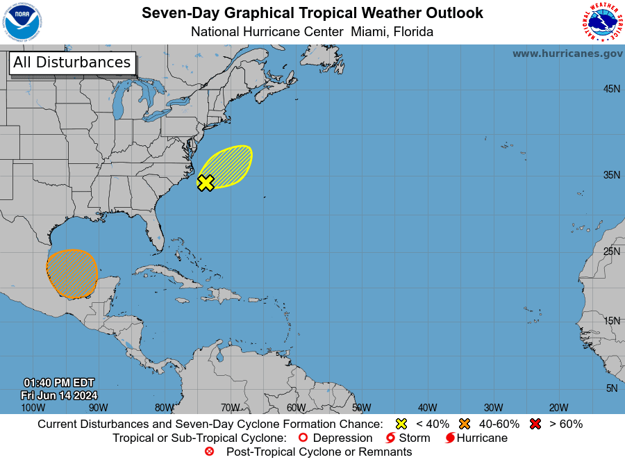
Should a low pressure system or tropical depression develop early next week, it is expected to remain well to the south of the middle and upper Texas coast. However, a broad counterclockwise flow around the area of low pressure is expected pull a plume of tropical moisture already in place across the Gulf of Mexico to the Texas coast beginning late Sunday. This plume of moisture is forecast to spread inland to the Interstate 35 corridor by Tuesday, and to central and southern Hill Country on Wednesday. The tropical moisture is expected to cause the development of scattered to numerous rain showers and thunderstorms.
Although direct wind impacts will remain well to the south of our area, wind speeds are forecast to increase a bit early next week as the pressure gradient tightens between the deepening area of low pressure to the south and building high pressure over the southeastern U.S. Wind speeds of 20-25 mph can be expected across the coastal plains region, and around 15-20 mph across Central Texas.
Weather Discussion for the Weekend and Next Week
Sunny, dry, and hot weather can be expected this afternoon through Sunday afternoon as a strong ridge of high pressure in the upper atmosphere slides east from New Mexico to lower Mississippi Valley. Thanks to some drier air mixing down to the surface, peak heat index readings through Sunday are forecast to remain below 102 degrees across the Hill Country and Central Texas regions, and below 106 degrees across the coastal plains region.
- High temperatures Friday through Sunday are forecast to be in the mid and upper 90s across the Hill Country and Central Texas, and into the mid-90s across the coastal plains.
There will be a 40 percent chance for scattered showers and thunderstorms across the Wharton and Matagorda Counties Sunday afternoon as some of the tropical moisture begins to push inland. The rest of the region should stay dry through Sunday night.
For Monday and Tuesday, widespread showers and thunderstorms are forecast across the coastal plains region as the deep tropical moisture continues to spread inland. The chance for rain will be around 60-70 percent. Across Central Texas, there will be a 20-30 percent chance for scattered rain showers and thunderstorms both days as some of the tropical moisture spreads further inland. Little to no rain is forecast across the Hill Country. High temperatures Monday and Tuesday are forecast to be in the low 90s across the Hill Country and Central Texas regions, and near 90 degrees across the coastal plains.
Wednesday through Thursday, the chance showers and thunderstorms is expected to around 40-50 percent across Central Texas and the Hill Country as the area of deep tropical moisture spreads further inland. A 60-70 percent chance for showers and thunderstorms will continue for the coastal plains. High temperatures both days are forecast to be near 88-90 degrees.
Friday into next weekend, the chance for rain is forecast to decrease to around 20 percent across the region as the majority of the deep tropical moisture shifts west toward the Rio Grande and northern Mexico. Expect a partly cloudy sky with high temperatures in the low and mid-90s.
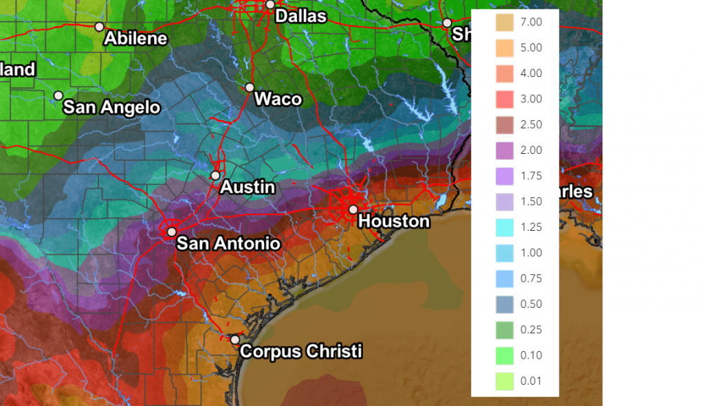
Rainfall Forecast
There remains a fair amount of uncertainty on rainfall amounts—especially since a tropical system has not even developed. But given the incoming tropical air mass, significant totals of rain are predicted for the coastal plains region. In addition, next week’s tropical-like atmosphere will be capable of producing high amounts of rain in a short period of time.
NOAA’s Weather Prediction Center rainfall forecast through 7 pm next Friday calls for totals of 4-6 inches across Matagorda County, and 2-4 inches across Colorado and Wharton Counties. Across Central Texas, totals of 1-2 inches are forecast. Across the Hill Country, totals of 0.5 to 1 inch are forecast.
NWS Rainfall Forecast Valid through 7 pm next Friday, June 21st
I urge everyone to stay up to date on weather developments over the weekend and early next week.
Bob
Social Media