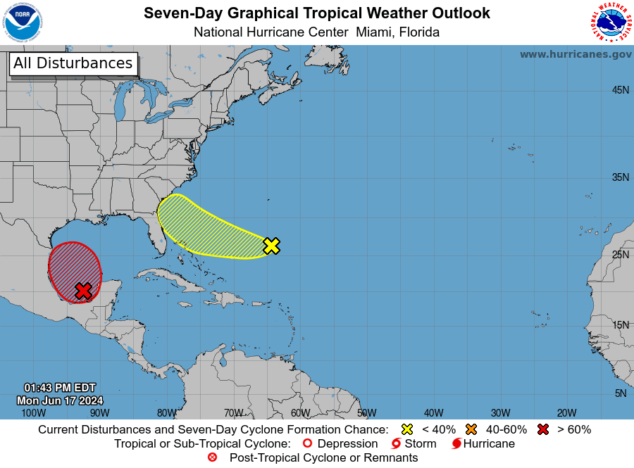
From the National Hurricane Center’s Monday midday update:
Satellite imagery and surface observations indicate a broad area of low pressure has now developed over the Bay of Campeche. Winds of 35-40 mph are occurring in an area well to the northeast of the center over the southern Gulf of Mexico. The system overall is still somewhat ragged and doesn’t yet meet the criteria to be termed a tropical cyclone. However, environmental conditions appear favorable for gradual development, and a tropical depression or tropical storm is likely to form by midweek while the low moves slowly west-north-westward toward the western Gulf coast/Mexican coastline. An Air Force Reserve Hurricane Hunter aircraft is currently en route to investigate this developing system.
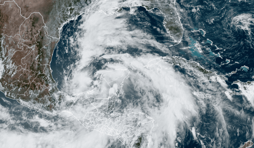
Colorado State University/NOAA/RAMMB 06/17/24 2:50 pm CDT
Regardless of whether this system develops into a tropical depression or not, the circulation around the area of low pressure is expected to pull a large area of deep, tropical moisture inland to South, Central Texas, and the Hill Country beginning Tuesday, continuing through late Thursday. As moisture levels increase, showers and scattered thunderstorms are forecast to increase in coverage and intensity. Forecasts are calling for significant totals of rain to fall over the area from the middle Texas coast and inland into the Hill Country.
For Monday afternoon and evening, scattered to numerous showers and thunderstorms can be expected across the coastal plains region as the leading edge of the tropical moisture begins to spread inland. The chance for rain will be near 70 percent. Rain amounts of 0.25 to 0.5 inches are forecast. Across Central Texas and the eastern Hill Country, there will be a 20 percent chance for scattered rain showers and isolated thunderstorms. Most of the rain and thunderstorm activity is predicted to diminish Monday night.
For Tuesday through Tuesday evening, increasing tropical moisture is expected to cause the development of periods of moderate to heavy rain across the middle Texas coast, extending inland to the southern counties of Central Texas. The probability for rain will be near 70-80 percent Across Central Texas and the Hill Country, scattered showers and thunderstorms are forecast to increase in coverage across the region in the afternoon. The probability for rain will be near 30 percent.
Wednesday through Thursday, periods of moderate to occasionally rain are forecast across the entire region as the plume of tropical moisture spreads inland from the coast. The probability for rain both days will be near 70-80 percent. The chance for rain is forecast to decrease beginning Thursday night as the plume of tropical moisture begins to exit to the west.
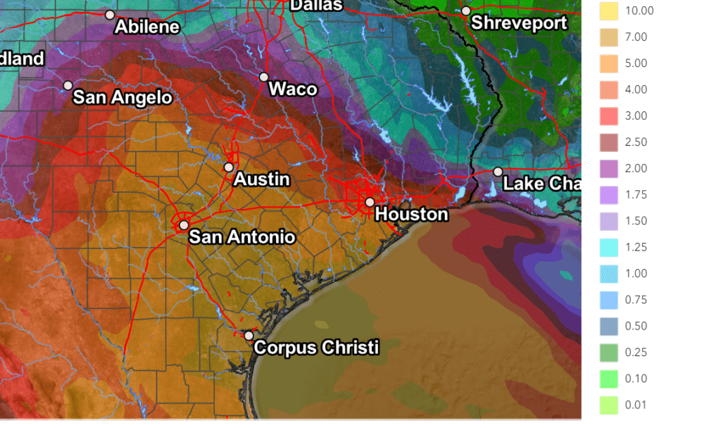
Rainfall forecasts valid through Thursday evening call for totals as high as 5 to 7 inches for the area stretching from the middle Texas coast, inland to the Austin area, and west to Fredericksburg and Mason. Totals of 7-10 inches are forecast for the area stretching from Corpus Christi, to San Antonio.
NWS Rainfall Forecast for the period 7 pm Monday through 7 pm Thursday:
The National Weather Service has posted a Flood Watch for Colorado, Wharton, and Matagorda counties for the period between Tuesday evening and late Wednesday night. Excessive runoff may result in the flooding of rivers, reeks, streams, and other low-lying and flood-prone locations across the area. Creeks and streams may rise out of their banks. Flooding may occur in poor drainage and urban areas.
Heavy rainfall will not be the only concern over the next couple of days. Strong coastal winds are likely Tuesday and Wednesday. Winds at the coast could gust over 40 mph. These winds will result in hazardous seas, rough surf, and dangerous rip currents. The National Weather Service has posted a Coastal Flood Watch for tonight through Wednesday night due to the prospect of water levels 4-5 feet (potentially up to 6 feet) above Mean Lower Low Water (MLLW) during high tide.
Generally speaking, the severe weather threat with the tropical rains over the next couple of days will be low. However, isolated damaging wind gusts cannot be ruled out, especially near the coast.
Looking out to the end of the week and the upcoming weekend, there will be a slight chance for some lingering showers on Friday, followed by generally dry weather Saturday and Sunday. High temperatures are forecast to be in the low and mid-90s.
Bob
Social Media