The focus of the weather this week will be on the heat. We are firmly in what is typically the hottest point of summer in Central and South Texas, and this week’s weather will definitely live up to that billing. Our nemesis, the dreaded heat dome, is forecast to gain greater influence on our weather throughout the week, likely leading to several consecutive days with triple digit temperatures.
After contracting westward over the weekend, the heat dome is now spreading back across Texas. Forecasts call for the center of the heat dome to set up across the southern Plains and northern Texas mid-week and remain over the area through at least Saturday. Sinking air under the heat dome is expected to cause a very stable atmosphere, abundant sunshine, and rain-free conditions throughout the week.
It’s going to be hot all week, but the hottest temperatures are predicted to occur Wednesday through Saturday as center of the heat dome gets closer to our area.
- High temperatures Monday and Tuesday are forecast to generally be near 98 to 100 degrees across the Hill Country and Central Texas regions, and in the mid-90s across the coastal plains
- High temperatures Wednesday through Saturday are forecast to generally be near 100-103 degrees across the Hill Country and Central Texas regions, and in the upper 90s across the coastal plains
Factoring in the humidity, peak heat index values Monday and Tuesday are forecast to be up to 106 degrees across Central Texas and the coastal regions. For Wednesday through Saturday, peak heat index readings are forecast to be up to 108 degrees across Central Texas, and up to 110 degrees across the coastal plains. Because of the forecast high heat index readings, the National Weather Service states they will likely be issuing Heat Advisories for parts of the area throughout the week.
Abundant sunshine and light winds will also result in high Wet Bulb Globe Temperature (WBGT) values. WBGT is a measure of the heat stress in direct sunlight and takes into account the temperature, humidity, wind speed, sun angle, and incoming radiation (i.e. cloud cover). Conditions this week are favorable for high to extreme WBGT risk, or values that are high enough to stress even the most active populations (i.e. those used to working or exercising outdoors) due to the high temperatures, abundant sunshine, and light winds. It will be particularly important for those who work outdoors to practice heat safety this week. Avoid any unnecessary outdoor activities during the peak heating of the day and remain hydrated.
Looking out further, Monday’s forecast solutions are showing modest support for a possible backdoor cold front to sink south into portions of North and East-Central Texas Sunday, as the center of the heat dome shifts further to the northwest. The front could possibly help generate a few rain showers across the northern half of the region next Sunday and Monday. As of now, no widespread or heavy rain is anticipated.
Next week, forecasts call for the heat dome to weaken slightly while it continues to hang out over the central and southern Plains. For our region, the sunny, dry, and hot weather looks to continue. Daily high temperatures are predicted to stay close to 100 degrees throughout the week.
Note that weather from the tropics could possibly influence on our region at some point next week. See the tropical weather section below.
Tropical Weather Outlook
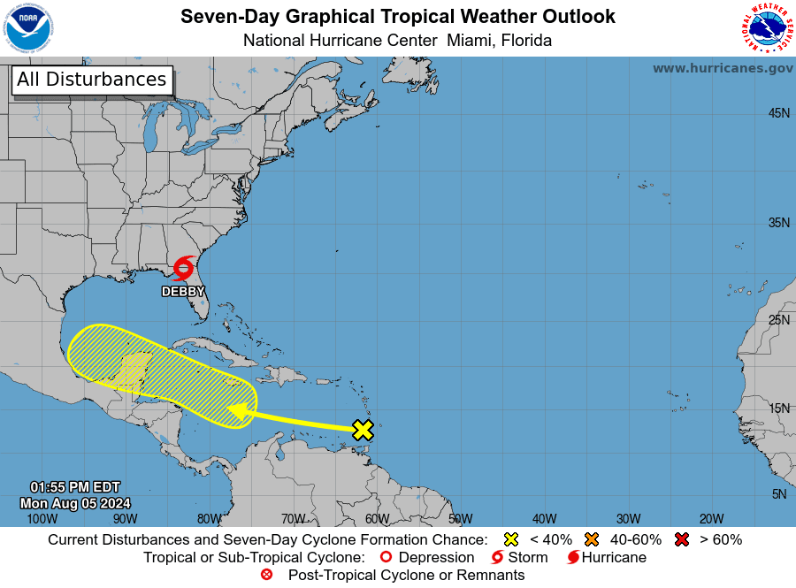
Tropical Storm Debby:
Hurricane Debby made landfall along the Florida Big Bend coast, near Steinhatchee, around 7 am CDT this morning. Maximum sustained winds at the time were near 80 mph.
As of 1 pm, Debbie has weakened to a tropical storms and was inland and centered about 10 miles northwest of Live Oak, Florida. Peak winds were down to 65 mph. Debby is expected to produce rainfall totals of 6 to 12 inches, with maximum amounts of 18 inches, across portions of central and northern Florida as well as central and northeast North Carolina through Wednesday morning. This rainfall will likely result in areas of considerable flash and urban flooding, with significant river flooding expected.
Disturbed Weather Near the Windward Islands
National Hurricane Center forecasters are closely monitoring an area of showers and thunderstorms associated with a tropical wave located near the Windward Island. Any development of this system should be slow to occur during the next couple of days while the system moves westward over the eastern Caribbean Sea. However, environmental conditions are expected to become more conducive for development later this week as the system moves across the western Caribbean Sea or the southern Gulf of Mexico.
NHC is currently giving this system a 30 percent chance for tropical development over the next seven days.
Ensemble forecasts from the GFS, ECMWF, and Canadian models all show some degree of development with this feature either in the western Caribbean Sea or southern Gulf of Mexico this weekend. The NHC’s 7-day tropical weather outlook calls for the system reach the Bay of Campeche by about next Sunday. Right now, it’s too early to tell where this potential tropical system will make landfall. I urge everyone to keep monitor the progress of this disturbance over the next few days.

Bob


Social Media