As we start back after New Years, all eyes are on an area of light to moderate rain that is spreading east across the Hill Country and Central Texas. The rain is being generated by a trough of low pressure in the upper atmosphere located over Far West Texas that is tracking to the east-southeast. As the trough moves over the northern half of the state Tuesday afternoon and Tuesday night, a widespread area of light to moderate rain is predicted to spread east across the Hill Country, Central Texas, and the middle Texas coast. A couple of isolated thunderstorms will be possible from the rain, but no strong or severe storms are anticipated. The rain is forecast to taper off from west to east after midnight Tuesday night. The rain is expected to be heaviest over the area located east of Interstate 35.
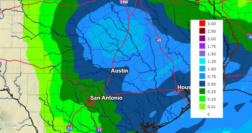
Rain amounts through Wednesday morning are forecast to average less than a quarter inch across the western Hill Country and be between a quarter inch and one across the remainder of the Hill Country. Across Central Texas and the middle Texas coast, totals are forecast to generally average between 0.5 and 1 inch.
NWS Rainfall Forecast Valid through 6 pm Wednesday:
Low temperatures Wednesday morning are forecast to generally be in the low and mid-40s.
With a wet ground and light winds Tuesday night, areas of fog are forecast to develop after midnight and continue into Wednesday morning. The low clouds and fog should lift late morning, with the sky becoming partly cloudy Wednesday afternoon. Tuesday’s temperature should warm to the mid-50s. Lows Thursday morning will be in the mid and upper 30s.
A mostly sunny to partly cloudy sky is forecast Thursday, with high temperatures in the mid and upper 50s.
Rain showers will return to the forecast Thursday evening and Thursday night as another Pacific trough of low pressure approaches from the west. A chance for rain will continue Friday morning into Friday afternoon as the trough moves over the state. The probability for rain will be near 60-70 percent. The rain should taper off from west to east Friday afternoon.
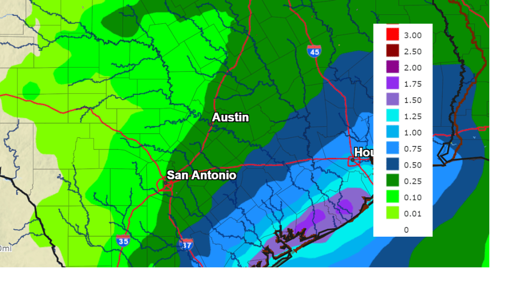
Totals from this next system are forecast to be heaviest near the coast and lowest across the Hill Country. Amounts are forecast to range from around a quarter inch across the western Hill Country, to close to two inches along the middle Texas coast.
NWS Rainfall Forecast Valid between 6 pm Thursday and 6 pm Friday:
Sunny and dry weather is forecast this upcoming weekend as the Friday system exits to the northeast. Expect high temperatures to be in the low and mid-60s, with lows in the mid and upper 30s.
Forecasts call for yet another Pacific trough of low pressure to move across the northern half of Texas next Sunday night and Monday. This system is showing signs of being a bit more dynamic and may cause some scattered thunderstorms across the area. Otherwise, expect another round of rain showers beginning after midnight Sunday night, continuing through next Monday evening. As of now, rain amounts are forecast to average around a half inch. However, these totals could go higher if thunderstorm activity becomes more widespread than is currently predicted.
After next Monday’s system, the Pacific wave train is forecast to slow down for a while. Dry and cool weather is predicted next Tuesday through Friday. After Monday’s high temperature close to 70 degrees, expect high temperatures next week to be in the 50s to low 60s, with lows in the 30s to low 40s.
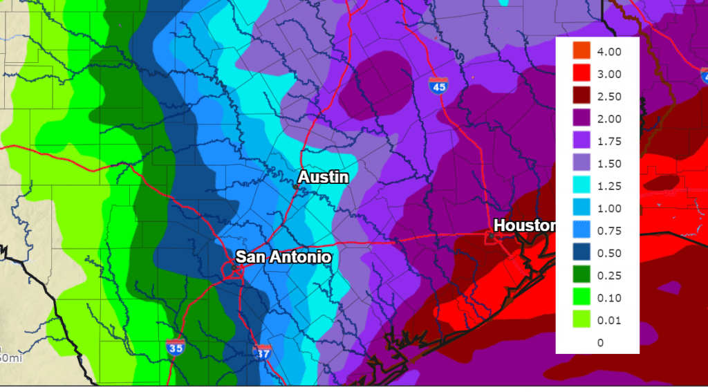
Adding together the projected rainfall from over the next seven days, totals are forecast to range from about a half inch across the western Hill Country, to around 1-1.5 inches across Central Texas, to between two and three inches across the coastal plains.
NWS Seven-Day Rainfall Forecast Valid through 6 pm Tuesday, January 9th:
No arctic air is forecast to spread into Texas through the middle of the month.
Earth at Perihelion
Earth will be at its closest distance from the sun of the year Tuesday at around 6:28 pm CST (This is called perihelion). Today, the Earth is 3.1 million miles closer to the sun than it will be at aphelion on July 5. Earth’s orbit around the sun is not perfectly circular, so there’s a perihelion and aphelion once per year.
Have a good week.
Bob
Social Media