The Wet and Unsettled Pattern Will Continue through the Weekend
July 23, 2024
The wet and unsettled weather pattern continues. Monday night into Tuesday morning, moderate to heavy rain developed and persisted across the Edwards Plateau and parts of the Hill Country. Widespread totals of 4-8 inches fell over the area from west of Rocksprings, to Kerrville, to Junction, to west of Rocksprings. Within this area, a couple of isolated totals of 9-10 inches were observed. Totals of 2-4 inches fell across parts of Mason and Gillespie Counties. Across much of the eastern Hill Country and the Austin/Interstate 35 corridor, totals ranged between 1 and 2.5 inches Very low totals have been recorded so far across the middle Texas coast.
Tuesday’s analysis continued to show an unusual trough of low pressure stretching from the Great Lakes to Far West Texas. Small, slow-moving waves of low pressure moving through the large trough, taking advantage of the very moist airmass, have helped to produce the recent period of moderate to heavy rain. Tuesday’s data indicates the broad trough is sagging slowly to the southeast, and this is expected to shift the focus for heavy rain over the next few days mainly to areas along and east of Interstate 35, rather than the Hill Country.
For Tuesday afternoon and Tuesday night, periods of rain showers and scattered thunderstorms look to continue across the eastern half of the Hill Country, Central Texas, and the middle Texas coast. Some of the rain showers will be slow movers, capable of producing large amounts of rain in short periods of time. Rain amounts between Tuesday afternoon and sunrise Wednesday are forecast to generally average between 0.5 and 1 inch, with isolated totals of 3-4 inches possible.
Wednesday through Sunday, the trough is predicted to remain nearly stationary across Central Texas. As a result, a good chance for scattered rains is expected to continue to across the entire region, with the most favorable area for rain occurring for areas along and east of Interstate 35. The probability for rain will range from 30-40 percent across the Hill Country, to near 40-50 percent across Central Texas, to near 80 percent across the coastal plains.
Daily rain amounts across the Hill Country are forecast to average near or less than a quarter inch. For Central Texas, daily rain amounts are forecast to average between a quarter and a half inch, with isolated totals of 1-2 inches possible. For the middle Texas coast, daily rain amounts are forecast to average between 0.5 and 1 inch, with isolated totals of 2-4 inches possible.
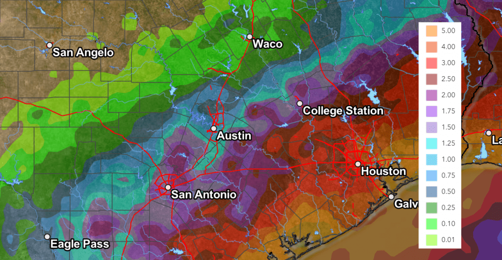
The Weather Prediction Center’s rainfall forecast for the next seven days calls for totals of 0.25 to 1 inch across the Hill Country, 1-2 inches across Central Texas, and 3-5 inches across the coastal plains.
NWS Rainfall Forecast for the Period 7 pm Tuesday through 7 pm Next Tuesday:
With soils becoming more saturated from previous days rains, flash flooding may become more of a threat over the next few days. This will be in addition to the urban and small stream type flooding.
The outlook for next week calls for a slight chance for rain Monday, with mostly sunny and dry weather for the balance of the week. High temperatures are forecast to be in the low and mid-90s.
Bob
Social Media