The Weather Will Trend Dry and Milder this Week, with the Next Chance Expected Sunday
NOV. 13, 2023
It was a cloudy, cool, and damp weekend. Although it rained for a fair amount of the time, rain amounts since Friday across the Hill Country and Central Texas have not been all that heavy, with most amounts averaging between a quarter and a half inch. The rain has been heaviest across the coastal plains, where 3-day totals have generally averaged between 1 and 2.25 inches.
The wet and unsettled pattern continues on this Monday. A trough of low pressure tracking north out of northern Mexico and Far West Texas is causing widespread light rain across the Hill Country, the Edwards Plateau, and the Concho Valley. A second area of light to moderate rain is falling across the middle and upper Texas coast, to the south of Interstate 10. As of midday, little to no rain was falling across Central Texas.
This afternoon into tonight, light rain showers look to continue across the region, with the most favorable area for rain continuing across the Hill Country and coastal regions. Here, the probability for rain will be near 80 percent. Across Central Texas, the probability for rain is forecast to be near 30 percent. The rain is predicted to taper off from west to east late evening through about midnight as the upper trough exits to the northeast. Additional rain amounts through Tuesday morning are forecast to average around a quarter inch across the Hill Country, less than a quarter inch across Central Texas, and around a half inch across the coastal plains. Isolated higher totals will be possible.
- High temperatures Monday will include the upper 50s across the Hill Country, and the low 60s at most other locations.
- Low temperatures Tuesday morning will range from the low 50s across the Hill Country, to the mid-50s near the coast.
Sunshine and dry weather will return to the area Tuesday as the upper trough exits and a stable ridge of high pressure high pressure begins to spread across Texas out of the Desert Southwest. Clouds will clear Tuesday morning and the sky will become mostly sunny by afternoon. With the sunshine, the temperature will trend warmer, with highs in the upper 60s.
Mostly sunny and dry weather is expected to continue Wednesday through Saturday as the ridge of high pressure remains across Texas. Milder readings are forecast. A weak, dry, cold front is predicted to sweep south across the area Friday night into Saturday morning, but it isn’t expected to do anything more than shift the wind out of the northwest.
- High temperatures Wednesday are forecast to be around 70 degrees.
- High temperatures Thursday through Saturday are forecast to be in the mid-70s.
- Lows Wednesday and Thursday mornings will include the upper 40s to 50 degrees across the Hill Country and Central Texas regions, and in the low 50s across the coastal plains.
- Lows Friday, Saturday, and Sunday mornings will range from the low 50s west, to the upper 50s near the coast.
The next change in the weather is forecast to take place late next Sunday into Monday when trough over the Plains helps push a Pacific cold front across the state. With limited moisture returning ahead of the front, only a slight chance to a chance for rain showers is forecast. Next, a Canadian cold front is predicted to spread across the area next Tuesday, binging slightly cooler air. As of now, rain amounts late Sunday through Tuesday are expected to remain below a quarter inch.
Mostly sunny and dry weather is forecast next Wednesday, continuing through the following Saturday. (This includes Thanksgiving Day). Daily high temperatures over this stretch are forecast to be in the 60s, with lows around 50-52 degrees. There is some thought a chance for rain may develop around the Sunday following Thanksgiving.
No unusually cold air is in the forecast for our region through the end of the month.
Tropical Weather Update
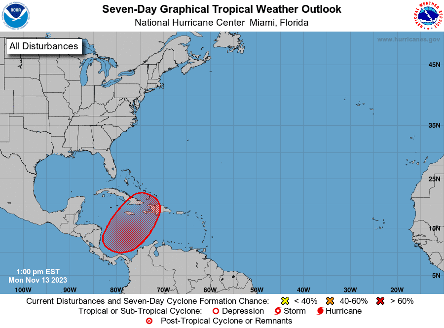
Hurricane season isn’t over with quite yet. National Hurricane Center forecasters indicate a broad area of low pressure is expected to form over the southwestern Caribbean Sea in the next few days. Environmental conditions appear favorable for additional development of this system thereafter, and a tropical depression is likely to form late this week while the system begins moving northeastward across the western and central portions of the Caribbean Sea. This system has the potential to produce heavy rains over portions of the Caribbean coast of Central America and the Greater Antilles towards the latter part of this week.
This system poses no threat to the Gulf of Mexico.
NHC forecasters are giving this system a 70 percent chance for tropical development over the next seven days.
Venus is Blazing Away in the Morning Twilight
If you’re wondering about that bright “star” in the sky before sunup, that’s the planet Venus. Venus, brilliant at magnitude –4.4, shines in the east-southeast sky all the way through dawn. It rises a good 2 hours before dawn’s first light, a weird late-night apparition coming up over the east horizon. You can’t miss it!
Have a good week!
Bob
Social Media