Rain showers and thunderstorms spread across the region Thursday, bringing strong winds, hail, and heavy rain to many locations. Fortunately, our region of the state didn’t see the magnitude of severe weather that was experienced in the Houston area Thursday evening. Thursday’s storms did bring more beneficial rain to the northern Hill Country and most of Central Texas. Doppler radar estimates and LCRA Hydromet gauges show the storms produced widespread totals of 1-2 inches over the area stretching from Brady and Saba, southeast to Burnet, Austin, and Lexington. But there was a sharp gradient to the rain, as amounts across the western/central Hill Country and the middle Texas coast generally stayed below a half inch.
NWS Estimate of Rain Falling between 7 am Thursday and 7 am Friday:
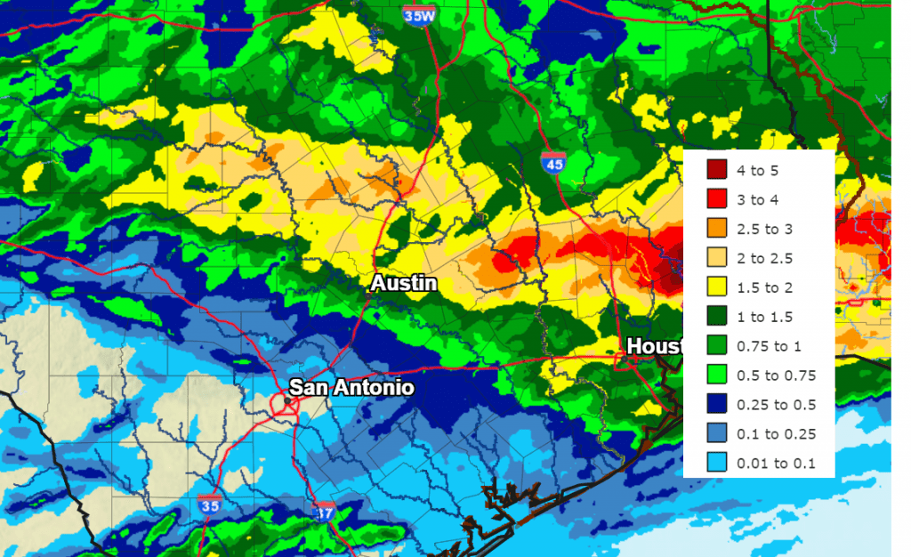
Data courtesy National Weather Service West Gulf River Forecast Center
The threat for additional widespread heavy rain and severe storms has come to an end. However, the last wave of low pressure associated Thursday’s storms was still located over northern Mexico, to the west of Laredo Friday morning. This system brought showers and thunderstorms to much of across South Texas Friday morning. Some of the showers have also extended northeast to the middle and upper Texas coast. Additional light to moderate rain showers and isolated thunderstorms look to continue across the middle Texas coast through early Friday evening. Rain amounts are forecast to remain below a half inch.
High resolution forecasts indicate this same wave of low pressure may spark the development of scattered thunderstorms along the Rio Grande mid to late Friday afternoon. Should storms develop, they’re predicted to track to the east and could spread to parts of the western Hill Country, to the west of Fredericksburg and Hondo late Friday afternoon and evening. Some of these storms will be capable of producing small hail and gusty winds to near 50 mph. The storms are forecast to dissipate by 9 pm as the trough of low pressure exits off to the east.
Friday’s weather across the central/eastern Hill Country and Central Texas is forecast to be mostly sunny and dry.
Friday’s temperatures will be some of the “coolest” we are going to see for a while, with highs mostly in the low 80s. Lows Saturday morning will range from the low 60s across the Hill Country, to the upper 60s across the costal plains.
A sunny, dry, and warmer weather pattern is forecast to take shape across the region Saturday when a ridge of high pressure spreads over Texas out of Mexico and the Desert Southwest. The ridge is forecast strengthen and remain over Texas through at least the middle of next week, causing continued sunny and warm weather. Temperatures and relative humidity levels are expected to steadily increase over the next few days.
- High temperatures Saturday and Sunday are forecast to be in the low 90s.
- Highs Monday through Wednesday are forecast to be in the mid-90s, with low 90s expected across the coastal plains.
- Lows Sunday and Monday mornings are predicted to be near 68-72 degrees.
- Lows Tuesday, Wednesday, and Thursday mornings are predicted to be in the low 70s across the Hill Country and in the mid-70s at most other locations.
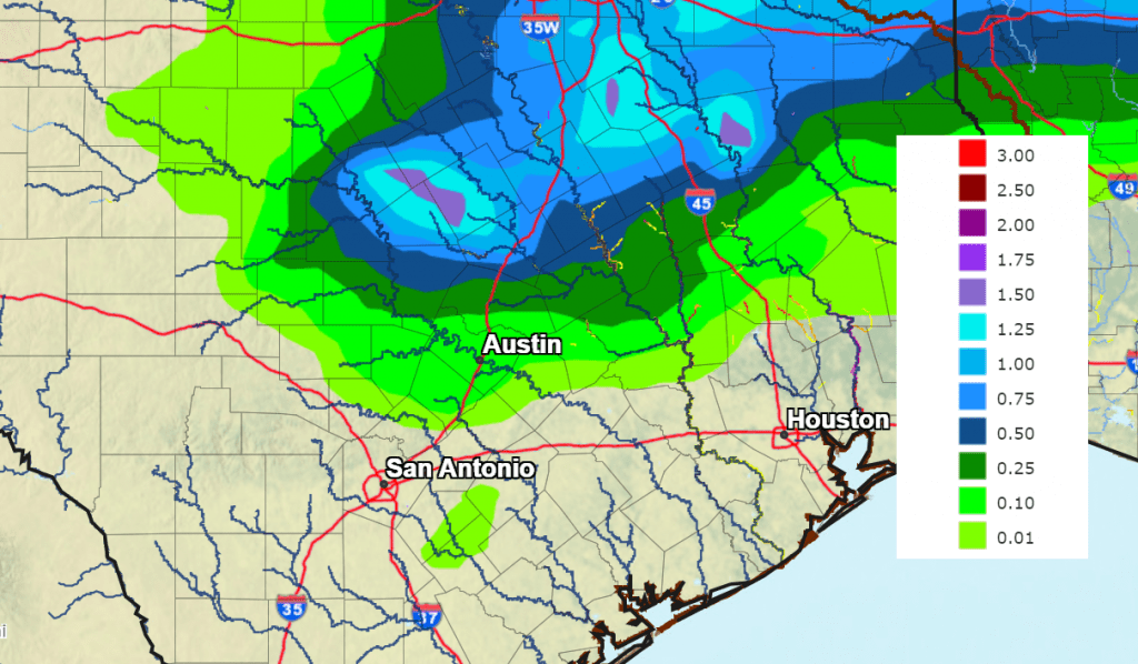
The ridge over Texas is forecast to weaken some around the middle of next week as a large trough of low pressure moves into the Desert Southwest. The trough is predicted to lift northeast into the Plains states Thursday and Friday, pushing a weak cold front into Texas. The front is forecast to reach as far south as Central Texas next Thursday before turning back to the north on Friday. The front may cause the development of scattered showers and thunderstorms across the Hill Country and parts of Central Texas late Wednesday into Thursday. National Weather Service forecasts call for totals of 0.5 to 1 inch across the northern Hill Country and the northern counties of Central Texas. Elsewhere, little rain is predicted.
NWS Rainfall Forecast for the Period 7 pm Wednesday through 7 pm Friday:
Looking out into late next week and Memorial Day weekend, weather conditions are shaping up to be mostly sunny and warm. There will be a slight chance for scattered rain showers across the region through the period. Expect daily high temperatures to be in the low and mid-90s.
Have a great weekend!
Bob
Social Media