A couple of large thunderstorm complexes spread southeast across the region late Thursday night into Friday morning. Although the storms didn’t produce any widespread severe weather, some of the storms did produce hail, very strong winds close to 50 mph, and moderate to heavy rain. Doppler radar estimates and surface reports show rainfall since 7 am Thursday generally totaled between 1 and 2.5 inches across the central and eastern Hill Country, between 1 and 1.5 inches across Central Texas, and between 1 and 2.5 inches across the middle Texas coast. LCRA’s highest gauged total through noon Friday was 3.15 inches, at gauge located in western Wharton County.
NWS Estimate of Rain Falling Between 7 am Thursday and 7 am Friday (courtesy West Gulf River Forecast Center)

Friday’s rain and thunderstorms are forecast to exit the middle Texas coast by mid-afternoon. A break from the rain and storms can be expected this afternoon across the eastern counties of the Hill Country and the area along and east of Interstate 35, as the atmosphere slowly recovers from the overnight storms. mid-80s.
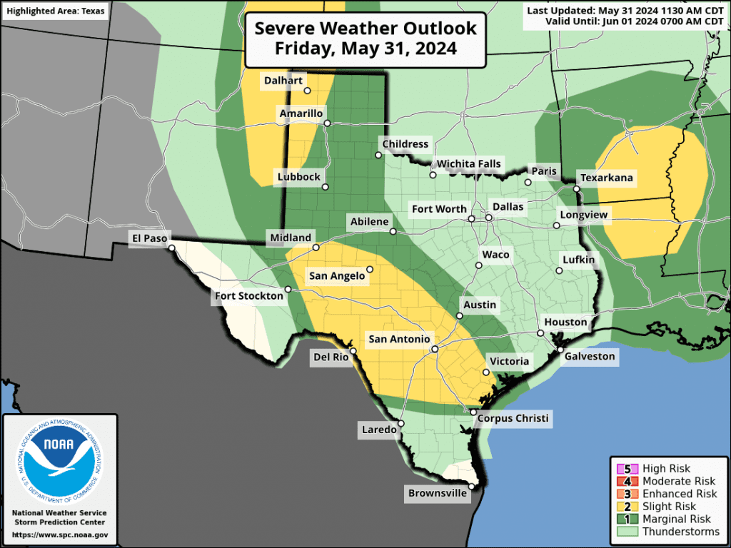
For the area located west of a line stretching from Brady to Gonzales, there will be a 30-40 percent chance for development of isolated to scattered thunderstorms Friday afternoon and evening. With a moist and fairly unstable atmosphere in place, some of these storms could become strong to severe. The Storm Prediction Center has placed this area under a 2 out of 5 risk for severe storms through Friday evening. Large hail and damaging winds will be the primary severe weather threats. Spotty total of between 0.5 and 1 inch are forecast.
Any thunderstorms which happen to develop Friday afternoon are predicted to dissipate by about 9 or 10 pm. Friday night’s weather is looking to be quiet, with no rain or storms around the area.
For Saturday, a moist and somewhat unstable air mass will remain across the region. However, forecasts don’t call for any waves of low pressure to move across the area or strong forcing for the development of widespread rain and storms. For most areas, expect a 30 percent chance for afternoon and evening showers and thunderstorms. Under a partly cloudy sky, the high temperatures will be close to 90 degrees.
Rain chances begin to lessen from Sunday into early next week as an upper level ridge over Mexico strengthens and slowly nudges northward into Texas. By the middle of next week, the ridge is forecast to stretch from northern Mexico, northwest to Idaho and Oregon. This change in the position of the ridge will shift the orientation of the recent storm track for our region. Instead of flowing east out of New Mexico like it has been for most of May, potential disturbances next week will now flow south out of the Plains states. From this direction, they won’t be able to take advantage of the dry line across West Texas.
Forecasts call for just a 20 percent chance for scattered afternoon showers and thunderstorms across the region Sunday and Monday. The threat for severe storms will be low and rain amounts, if any, should total less than a quarter inch. High temperatures both days are predicted to be in the low 90s. Expect a mostly sunny to partly cloudy sky.
For Tuesday into Wednesday, mostly sunny and dry weather is forecast. High temperatures are predicted to be in the low and mid-90s.
A slight chance for scattered rain showers and thunderstorms is forecast across the region Wednesday night into Thursday as a weak wave of low pressure tracks south out of the Plains states. Rain amounts, if any, should total less than a quarter inch.
Sunny, dry, and hot weather is forecast late next week into next weekend as the ridge of high pressure remains over the area between northern Mexico and the northwestern U.S. High temperatures are forecast to be in the mid-90s.
The outlook for the week of June 10th calls for little change in the weather pattern, with high temperatures staying mostly in the mid and upper 90s.
Tropical Weather Outlook
Saturday, June 1st, will mark the official start to the Atlantic Hurricane Season.
At the current time, weather conditions are very quiet across the tropical Atlantic. There are no systems in place which pose a threat for tropical development over the next seven days.
Have a great weekend!
Bob
Social Media