Quiet, pleasant, and fall-like weather is in place as we close out the workweek. A stable ridge of high pressure covering the eastern half of the country is keeping the storm track well up to our north and west, resulting in continued dry weather. Friday’s weather maps did show a trough of low pressure over the western and southwestern U.S. The trough is pulling clouds and a limited amount of moisture from the Gulf of Mexico, northwest across Texas and into the Desert Southwest. These clouds will likely persist across the area through Saturday then diminish Sunday as the trough lifts off to the northeast. Expect a partly cloudy to mostly sunny sky Friday afternoon through Saturday. A weak disturbance embedded within this flow off the Gulf may produce a few spotty, light showers across parts of Central Texas Friday afternoon. However, no significant rain is forecast.
Unfortunately, the atmosphere will likely be too dry to support the development of any additional rain.
Southeasterly breezes with gusts to near 25 mph are forecast Friday afternoon through Saturday. Wind speeds Sunday are forecast to decrease to a range of 10-15 mph. Due to the southeasterly breezes, temperatures are forecast to trend slightly warmer through the weekend.
- High temperatures Friday and Saturday are forecast to generally be in the low 80s
- High temperatures Sunday are forecast to be in the mid-80s
- Lows Saturday, Sunday and Monday mornings will include the mid and upper 50s across the Hill Country, and the upper 50s to low 60s across the remainder of the region
Sunny, dry, and warmer weather is forecast next week as the ridge of high pressure to our east shrinks and sets up over the south central U.S. Once again, this will keep the storm track well up to the north of Texas. With a stronger ridge in place, temperatures are forecast to trend warmer, with a return of the 90s.
- High temperatures Monday are forecast to be in the mid-80s
- High temperatures Tuesday are forecast to be in the upper 80s
- High temperatures Wednesday through Friday are forecast to be near 90-92 degrees across the Austin/Central Texas area and coastal region, and near 88-90 degrees across the Hill Country
- Low temperatures next week are forecast to generally be in the low and mid-60s
Looking out further into next weekend and the last few days of October, the long-range forecast solutions show some minor changes in the weather pattern. The ridge of high pressure across Texas is forecast to weaken, but there are no signs of a strong cold front or significant trigger for rain taking place across Texas. High temperatures are forecast to trend a little lower, with highs mostly in the mid to upper 80s, with lows in the mid-60s. Some forecast solutions do show a slight chance for rain developing the last couple of days of the month.
Tropical Weather Update
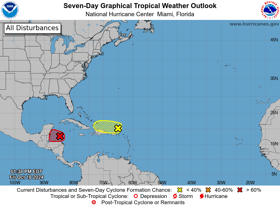
National Hurricane Center forecasters continue to monitor two areas of disturbed weather, but neither system poses a threat to the western Gulf of Mexico or the Texas coast.
Across the northwestern Caribbean Sea, a widespread area of showers and thunderstorms associated with a broad area of low have become a little better defined over the past day to the north of eastern Honduras. Environmental conditions appear conducive for some additional development over the next day or so, and a short-lived tropical depression or storm could form before the system moves inland over Belize and the Yucatan Peninsula of Mexico on Saturday. NHC forecasters are giving this system a 70 percent chance for tropical development over the next couple of days.
Across the southwestern Atlantic, to the north of Puerto Rico and the Virgin Islands, a trough of low pressure is producing disorganized showers and thunderstorms that extend for a couple hundred miles north of Puerto Rico. Development, if any, of this disturbance should be slow to occur while it moves quickly westward to west-northwestward at around 20 mph. The system is forecast to track north of Puerto Rico and the Virgin Islands today, then near Hispaniola and the southeastern Bahamas this weekend. Further development is not expected beyond this weekend due to strong upper-level winds developing early next week. NHC forecasters are giving this system only a ten percent chance for tropical development over the next seven days.

Elsewhere, there are no systems in place which pose a threat for tropical development over the next seven days.
Comet Tsuchinshan–ATLAS Update
Naked-eye observations of Comet Tsuchinshan–ATLAS aren’t as easy as they were a few nights ago. The comet is starting to dim as it moves further away from Earth. Nevertheless, observers say the comet is still an easy target for binoculars and smartphones. Look to the western sky starting about 45 minutes after sunset. Find the bright planet Venus and look up a bit higher up in the sky. (see sky map below)
A tip if you use your phone camera, point your phone toward the west and take a 10 second exposure in Night Mode to see the comet.
Have a great weekend!
Bob


Social Media