Reports from an Air Force Reserve Hurricane Hunter aircraft indicate Beryl has weakened slightly Tuesday afternoon. Earlier Tuesday, Beryl was at category 5 strength, with maximum sustained winds of 160 mph. This afternoon’s data shows peak sustained winds are down slightly to 155 mph, making Beryl a category 4 hurricane on the Saffir-Simpson Hurricane Wind Scale.
As of 4 pm CDT, the eye of hurricane Beryl was passing south of the Dominican Republic, situated about 420 miles east-southeast of Kingston, Jamaica. Beryl is beginning to encounter some wind shear and weakening is forecast Tuesday night through Wednesday. However, Beryl is still forecast to be near major hurricane intensity when it moves into the central Caribbean and passes near Jamaica on Wednesday and the Cayman Islands Wednesday night and Thursday. Additional weakening is expected thereafter as Beryl encounters stronger wind shear, though Beryl is forecast to remain at hurricane strength through the northwestern Caribbean.

NOAA/Colorado State University/RAMMB 2:30pm CDT 07/02/2024
Beryl is being steered to the west-northwest by a strong subtropical ridge currently centered over the southern United States. This west-northwesterly motion is expected to push Beryl across the central and northwestern Caribbean for the next few days, bringing the center near Jamaica Wednesday night, and the Yucatan Peninsula Thursday night. After that, a significant spread in the track guidance develops when Beryl emerges into the southwestern Gulf of Mexico, due mainly to model differences in the strength and location of a break in the subtropical ridge that is forecast to develop over the southern United States in the coming days.
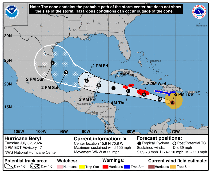
The forecast track for late week and this weekend is still quite uncertain. But it is important to point out the super-ensemble mean and the official National Hurricane Center tracks have both shifted northward over the past 24 hours. Beryl is forecast to cross into the southern Gulf of Mexico Friday night–the same time the ridge of high pressure over the southern U.S. will be breaking down and moving to the east. The forecast solutions are each handling this breakdown a little differently.
Due to increased wind shear across the western Gulf of Mexico, Beryl is predicted to be weaker, most likely at tropical storm strength, when it crosses the southern Gulf of Mexico and makes landfall sometime late Sunday.
Based on the latest ensemble of model solutions from Tuesday afternoon, an eventual path toward the mouth of the Rio Grande river appears to be a much stronger possibility, compared to recent forecasts. Based on this change, clouds and rain showers associated with the outer circulation of Beryl can be expected to begin spreading northwestward toward South and Central Texas on Sunday, with a chance for rain continuing next Monday and Tuesday.
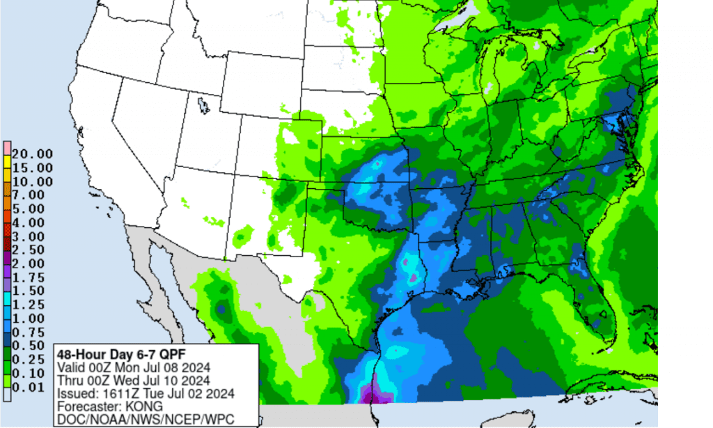
The Weather Prediction Center’s updated rainfall forecast for next Monday and Tuesday calls for totals of 1-1.25 inches to occur across the middle and upper Texas coast, with lower totals inland across Central Texas and the Hill Country. Please use this forecast as just a guide, due to the uncertainty in Beryl’s projected path and intensity.
NWS Rainfall Forecast for the Period 7 pm Sunday through 7 pm Tuesday:
Again, there’s still much uncertainty with regards to impacts for Texas at this time. Stay tuned for additional updates as the forecast path and intensity of Beryl becomes better resolved by the forecast solutions.
Bob
Social Media