Sunny and Mild through Late Week. Widespread Rain Expected Late Friday into Saturday
JAN. 29, 2024
In the wake of the arctic and wet weather experienced over the past couple of weeks, a quiet and dry weather pattern has now set up across Texas. Forecasts call for a stable ridge of high pressure in the upper atmosphere to remain over the area through late week, causing continued benign weather conditions. The sky will be clear to mostly sunny Monday through Thursday, with a partly to mostly cloudy sky developing on Friday. Expect mild days and cool nights through late week.
- Daily high temperatures this week are predicted to be near 68-72 degrees.
- Low temperatures Tuesday and Wednesday mornings are forecast to be in the low and mid-40s.
- Low temperatures Thursday and Friday mornings are forecast to be in the upper 40s to low 50s.
A change in the weather is forecast to take place Friday night through Saturday when a Pacific trough of low pressure moves across North Texas out of the Desert Southwest. This system is expected to pull clouds and moisture north from the Gulf of Mexico beginning Friday afternoon, followed by the development of rain showers and scattered thunderstorms Friday evening and Friday night. Forecasts call multiple rounds of rain showers and isolated thunderstorms to spread across the area Saturday through Saturday evening as the upper trough move across North Texas. The chance for rain looks to diminish Saturday night and toward daybreak Sunday.
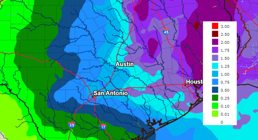
Similar to what occurred with the last rain event, the heaviest rain from this next system is forecast to occur over the area along and east of Interstate 35, with somewhat lower amounts expected across the Hill Country. With the ground still very wet from recent rains, this next round of rain could result in considerable runoff and potential flooding for areas east of I-35.
The National Weather Service rainfall forecast for the upcoming period calls for totals of 0.25 to 0.5 inches across the western Hill Country, and close to an inch across the eastern Hill Country. For the rest of the region totals are forecast to generally average between 1 and 1.5 inches.
NWS Rainfall Forecast for the Period 6 pm Friday through 6 pm next Monday:
A Pacific cold front is predicted to push east across the area early Sunday, bringing dry and slightly cooler air. Mostly sunny conditions are forecast Sunday, continuing through most of next week. Due to a strong pressure gradient behind the cold front, quite breezy conditions are forecast to develop across the area next Sunday and continue through Monday. Expect northwesterly breezes at 15-25 mph, with occasional higher gusts.
Daily high temperatures next week are forecast to be mostly in the low 60s, with lows in the 40s to near 50 degrees.
Long-range forecasts show the next chance for rain developing sometime late next week.
Have a good week.
Bob
Social Media