…A Winter Storm Warning has been posted for areas along and east of Interstate 35, including the Austin metro area and the coastal plains, from 6 pm Monday through 6 pm Tuesday…
…A Winter Weather Advisory has been posted for the eastern Hill Country from 6 pm Monday through 6 pm Tuesday…
…Accumulating snow, sleet, and ice will make travel difficult and inadvisable within the warning area Monday night through Wednesday morning…
Weather Highlights
- Confidence has increased for the development of accumulating snow, sleet and ice for areas along and east of Interstate 35 Monday night through midday Tuesday
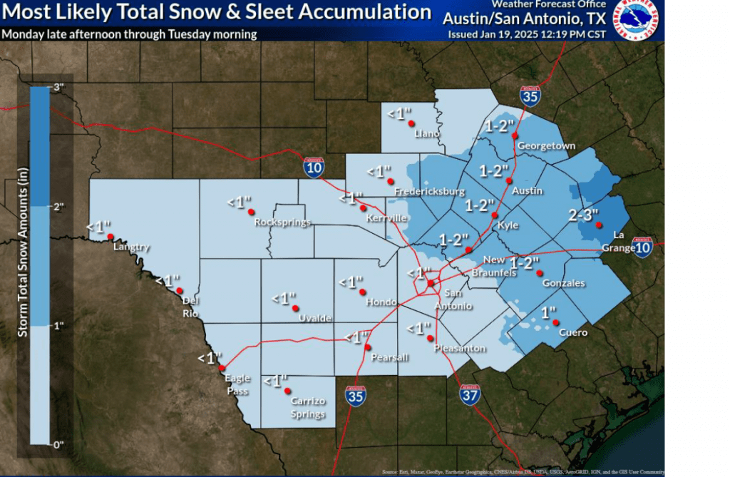
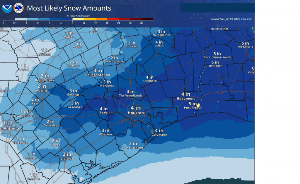
- Forecasts call for snow and ice accumulations through Tuesday afternoon of 1-2 inches for areas along the I-35 corridor (including the Austin metro). Accumulations to near 3 inches are forecast for Layette and Lee Counties. Accumulations of 3-5 inches are forecast for the coastal plains
- The snow and ice is expected to make travel hazardous and inadvisable Monday night through midday Wednesday
- Very cold temperatures will continue through Wednesday night. Readings Tuesday night look to be the coldest of the week, with lows Wednesday morning dipping into the upper teens at most locations
Discussion
The focus of today’s report will be on the increased threat for wintery precipitation across the region from Monday night till about midday Tuesday. Before I get into that, I did want recap the latest low temperature forecast. Readings Tuesday night into Wednesday morning are now expected to be a bit colder than previously predicted. Do note Tuesday’s high temperatures are forecast to only be in the low and mid-30s.
Low Temperatures Forecast this Week:
- Monday morning: Upper teens to 20 degrees across the Hill Country, 20-22 degrees across Central Texas, mid 20s coastal plains
- Tuesday morning: Low 20s Hill Country and Central Texas, and mid-20s coastal plains
- Wednesday morning: Between 15 and 18 degrees across the Hill Country, Central Texas and coastal regions
- Thursday morning: Mid-20s across the entire region
After a very cold and clear start to Martin Luther King Jr. day, clouds are forecast to quickly increase from south to north beginning around midday Monday in response to a trough of low pressure tracking southeast out of northwest Texas. Sunday’s suite of forecast solutions are now in good agreement this system will begin to pull moisture northwest from the Gulf of Mexico, creating an overrunning pattern of clouds and precipitation. The moisture is forecast to be most abundant across the coastal plains, where the precipitation will likely be the heaviest. Forecasts call the precipitation to set up in training bands, which will have the potential to produce high totals of rain, sleet, and snow. Lower amounts of precipitation are forecast further inland where the moisture will be less plentiful.
Light mixed precipitation, mainly in the form of light rain and sleet is forecast to develop across the region sometime Monday evening. The precipitation is expected to increase in coverage and intensity throughout the evening and toward midnight. Across the Hill Country and Central Texas regions, the precipitation is predicted to transition to mainly snow showers with some occasional sleet around midnight and continue into Tuesday morning. The precipitation is forecast to taper off from west to east late Tuesday morning as the upper trough exits to the east. For areas south of Interstate 10, a mixture of rain, freezing rain, and sleet is forecast after midnight Monday night. A mixture of mainly snow showers and sleet is forecast from daybreak Tuesday till about midday. Dry weather is forecast beginning Tuesday afternoon as the upper trough exits to the northeast.
Snow and Sleet Accumulations
- For the eastern Hill Country, extending north to San Saba, snow and sleet totals are forecast to generally average less than 1 inch. Ice accumulations are forecast to be close to 0.01 inch.
- For the Austin and Central Texas region: Snow and sleet totals of 1-2 inches are forecast. Lee and Fayette Counties could see snow totals up to 3 inches. Sleet/Ice totals are forecast to average around 0.01 inches.
- For the Middle Texas Coast: Snow totals of 3-5 inches are forecast. Isolated higher totals will be possible. Ice accumulation up to a tenth of an inch will be possible


Travel across the area is expected to become difficult and inadvisable, especially across elevated bridges and overpasses, as roads become slick and hazardous beginning Monday night and continuing into Tuesday. Due to the very cold temperatures Tuesday afternoon, most of the snow and sleet on the ground won’t have a chance to melt Tuesday afternoon. Therefore, hazardous travel conditions will likely extend into Wednesday morning. Temperatures are forecast to warm into the mid-40s Wednesday afternoon, which should help to melt most of the snow and ice.
Partly cloudy and milder weather is predicted beginning Thursday as the arctic air finally moves off to the east. High temperatures in the mid and upper 60s are forecast next weekend.
Bob


Social Media