Here is my Sunday update on the outbreak of arctic air.
Key Messages
- Isolated/patchy freezing drizzle is being reported across parts of Central Texas and this will likely continue through the afternoon
- A Winter Weather Advisory has been posted for the region and will remain valid through noon on Monday
- There will be a 60 percent chance for light freezing rain/freezing drizzle and sleet Sunday evening thru Monday morning
- Minor ice accumulations up to a tenth of an inch are forecast
- The ice will accumulate on exposed surfaces, including bridges and elevated surfaces
- The arctic air has arrived and will remain in place into Wednesday morning
- Forecasts call for the coldest temperatures to occur Monday night and again Tuesday night
- Bitterly cold wind chill values mainly in the single digits and teens, especially at night into the morning hours
Discussion
The arctic cold front pushed through our area Saturday night, bringing a drastic change in the temperature. As of midday Sunday, readings ranged from the mid and upper teens across the Hill Country, to the mid-20s across Central Texas, to the low and mid-40s towards the coast. The temperature is forecast to remain nearly steady across the region this afternoon. Readings do look to fall into the 30s across the coastal plains region late this afternoon and evening.
There have been numerous reports of very light freezing rain and freezing drizzle across parts of Central Texas, including the Austin metro area, this morning. It has become apparent the weak overrunning pattern has started a bit earlier than was previously called for. As a result, occasional very light freezing rain is expected to continue across the Hill Country and Central Texas regions through Sunday afternoon. Only trace amounts are predicted.
Forecasts continue to point to the development of a more widespread coverage of light wintery precipitation across the Hill Country and Central Texas regions early Sunday evening, continuing through Monday morning. The light wintery precipitation is forecast to spread southeast into the coastal region after midnight Sunday night. The precipitation is forecast to mainly take the form of light freezing rain and freezing drizzle, with some occasional sleet pellets. The precipitation is predicted to continue into Monday morning, then diminish from west to east mid to late morning. The probability for precipitation has increased to near 60 percent. Precipitation amounts are still expected to remain below a tenth of an inch.
National Weather Service Ice Accumulation Forecast through 6 pm Monday:
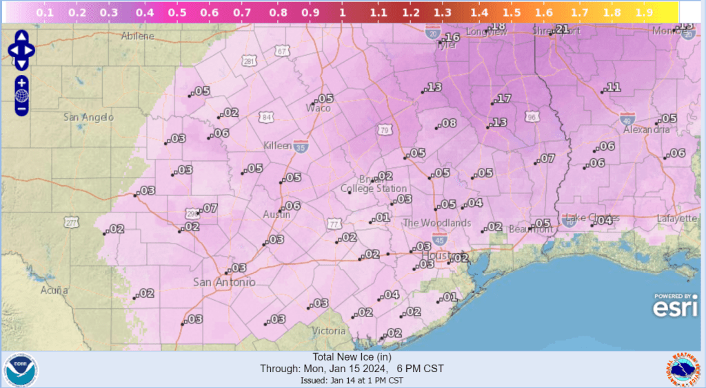
Due to the threat for light wintery precipitation, the National Weather has posted a Winter Weather Advisory for the Hill Country, Central Texas, and the middle Texas coast valid through noon on Monday. Hazardous driving conditions may develop on bridges and elevated structures.
- Low temperatures Monday morning are forecast to be in the upper teens across the Hill Country, in the lower 20s across Central Texas, and the upper 20s to 30 degrees across the coastal plains.
Although the precipitation is forecast to come to an end Monday morning, a cloudy to mostly cloudy sky is forecast to continue Monday afternoon and Monday night. The clouds are forecast to decrease early Tuesday, followed by a generally clear sky Tuesday afternoon through Wednesday. Breezy to windy conditions are predicted beginning Monday night, continuing through Tuesday. Expect wind speeds of 10-20 mph, with occasional gusts to 35 mph. This will likely create dangerous wind chills in the single digits. Parts of the Hill Country and the northern counties of Central Texas, including Austin, could see wind chill readings in the single digits and single digits below zero during this period.
Milder temperatures are forecast to develop Wednesday and continue into Thursday. Forecasts do indicate another arctic cold front will move across our area late Thursday into night. Due to minimal moisture, no precipitation is expected with the front. Fortunately, this next arctic air mass isn’t looking quite as cold or as long lasting as the one currently in place. A hard freeze is forecast Friday night into Saturday morning as temperatures fall to the mid-20s. Weekend temperatures will feature highs in the 40s and 50s, with lows in the 30s.
Temperatures
- High temperatures Monday are forecast to be in the upper 20s across the Hill Country, around 28-30 degrees across Central Texas, and in the low 30s across the coastal plains.
- Lows Tuesday morning are predicted to be between 10 and 15 across the Hill Country, between 15 and 20 degrees across Central Texas, and in the low 20s across the coastal plains.
- High temperatures Tuesday will range from the upper 20s across the Hill Country to the mid-30s across the coastal plains.
- Low temperatures Wednesday morning are foretaste to be around 15 degrees across the Hill Country, between 15 and 20 degrees across Central Texas,, and around 20 degrees across the middle Texas coast.
- High temperatures Wednesday look to be around 48-50 degrees.
Bob
Social Media