The doldrums of summer are finally coming to an end! Granted, we still have another 3 days of very hot temperatures in front of us, but all signs are pointing to the persistent dry and very hot summer pattern coming to an end next week. The wait for prolonged sub-100 degree weather is just about over! Beginning Tuesday, the Hill Country and Central Texas will enjoy temperatures below 100 degrees, and the temperature looks to stay below 100 degrees through the foreseeable future.
But before we get to the less hot temperatures next week, summer is going to flex its muscles one more time today and Saturday. Friday’s analysis showed a strong heat dome stretching from central Mexico to the southern Rockies, and centered over southeastern New Mexico. Due to the close proximity of the heat dome center, Friday is shaping up to be the hottest day of the week, with some of the hottest Septembers ever observed.
- High temperatures Friday are predicted to be between 104 and 108 degrees across the Hill Country and Central Texas regions, and between 102 and 106 degrees across the coastal plains.
Forecasts call for the heat dome to slowly weaken and retreat to the southwest beginning on Saturday. As a result, high temperatures are predicted to step down slowly this weekend into early next week.
- High temperatures Saturday are predicted to be between 103 and 105 degrees across the Hill Country and Central Texas regions, and be between 100 and 103 degrees across the coastal plains.
- High temperatures Sunday are predicted to be between 100 and 102 degrees across the Hill Country and Central Texas regions, and between 98 and 100 degrees across the coastal plains.
- High temperatures Monday are predicted to be near 98-100 degrees across the entire region.
There will be a slight chance for scattered mainly afternoon and evening showers and thunderstorms across the region Saturday, Sunday, and Monday as a weak cold front sags southwest into our area out of Oklahoma, Arkansas, and Louisiana. With a less intense heat dome overhead, the atmosphere will be more favorable for the development of a few scattered rain showers and thunderstorms along and south of the front. The probability for rain each day will near 20-30 percent. Rain amounts, if any, should total less than a quarter inch. Do note that a couple of the developing thunderstorms could be strong—producing gusty winds and small hail. Wind speeds this weekend are forecast to generally be between 5 and 10 mph.
Forecasts point toward an increasing chance for periods of rain showers and scattered thunderstorms across the region beginning late Tuesday and continuing through the end of the week. A somewhat stronger cold front is forecast to push south out of Oklahoma and spread south across Central Texas and the coastal plains region Wednesday, moving off the middle Texas coast Wednesday night. Showers and thunderstorms are forecast to develop ahead of and along the cold front. Behind the cold front, an overrunning pattern looks to set up Wednesday night and continue through next Friday night. Periods of rain showers thunderstorms are forecast as occasional waves of low pressure track southeast across Texas out of the southern Rockies. Some of the heaviest rains look to occur later next week.
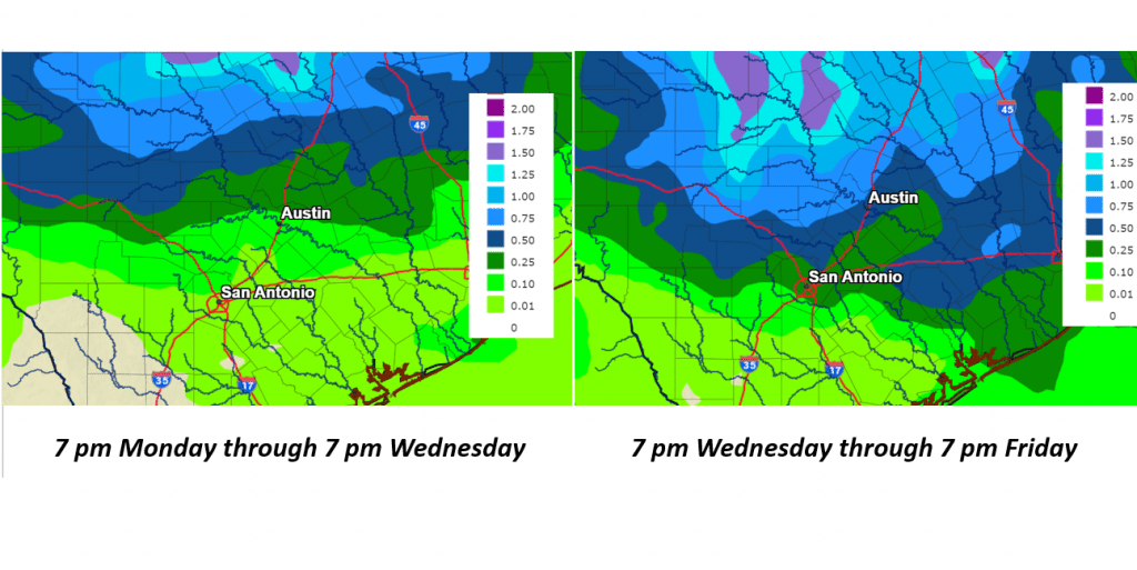
Rain forecasts show the highest rain totals next week will occur across the northern Hill Country and the northern counties of Central Texas, with somewhat lower totals expected across the southern counties of Central Texas and towards the coast.
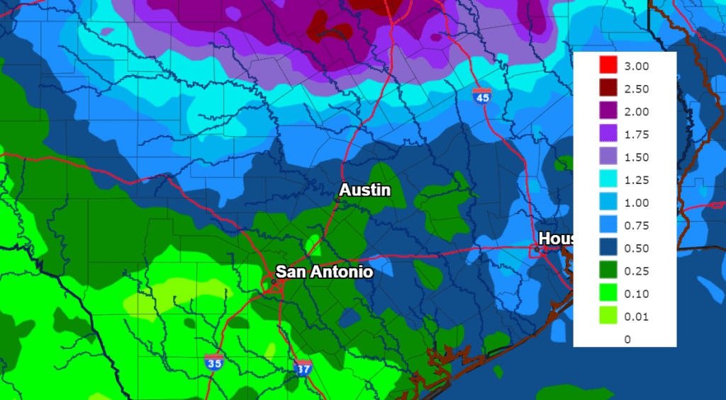
For Tuesday and Wednesday, totals are forecast to average between 0.5 and 1 inch across the northern Hill Country and around a quarter inch or less at most other locations. For Thursday and Friday, totals are forecast to range from 0.5 to 1.5 inches across the northern Hill Country, to around a half inch across Central Texas and the middle Texas coast.
NWS Rainfall Forecast:
NWS Rainfall Forecast for the Period 7 pm Friday through 7 pm Next Friday:
Expect a partly to occasionally mostly cloudy sky Wednesday through Friday.
High temperatures Tuesday through Friday are predicted to trend down several degrees due to the retrograding heat dome and the two cold fronts.
- High temperatures Tuesday through Friday are forecast to be in the upper 80s to 90 degrees across the northern Hill Country, in the low to mid-90s across Central Texas and the middle Texas coast.
Looking out into next weekend and the week of September 18th, generally dry and warm weather is forecast, with high temperatures mostly in the mid and upper 90s.
Tropical Weather Update
Weather conditions are quiet across the Gulf of Mexico and the Caribbean Sea. Tropical cyclone development is not expected here over the next seven days.
Across the tropical Atlantic, National Hurricane Center forecasters are closely monitoring Hurricane Lee, located several hundred miles east of the northern Leeward Islands, and Tropical Storm Margot, located over the eastern tropical Atlantic. Lee has become a category 4 hurricane, with maximum sustained winds of 130 mph. Lee is expected to pass well to the north of the northern Leeward Islands, the Virgin Islands, and Puerto Rico over the weekend and into early next week.
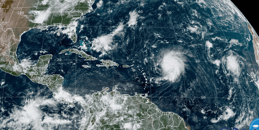
NOAA/Colorado State University/RAMMB 09/08/23 12:20 pm CDT
Comet Nishimura Swinging By for Binoculars and Telescopes and Just Maybe Our Eyes
Comet Nishimura is plunging toward the sun for a close encounter inside the orbit of Mercury on Sept. 17th. Increasing heat is causing the comet to brighten rapidly. Currently shining like a 5th magnitude star, it is barely visible to the unaided eye, but an easy target for digital cameras.
The comet starts this week very low in the dawn sky in the constellation Leo. You’ll need a low view to the east-northeast on the mornings of September 9th, 10th, and maybe 11th. The waning crescent Moon won’t pose interference. By the 13th or 14th the comet shifts to the low evening sky, just above the west-northwest horizon during early to mid-twilight. Day by day it will move leftward, but no higher, to stand barely over the west horizon on its perihelion date, the 17th. This is also its predicted date of peak brightness — possibly 2nd magnitude, not counting the ill effects of bright twilight and atmospheric extinction that low.
Have a good weekend.
Bob
Social Media