…Widespread rain, possibly heavy at times, is expected across the region Wednesday night through Friday…
…A Flood Watch has been posted for Wharton and Matagorda Counties from Thursday morning through Friday afternoon…
The combination of a vigorous trough of low pressure moving east out of northern Mexico and a feed of deep moisture is expected to cause rounds of showers and thunderstorms across the region beginning Wednesday afternoon, continuing through Friday. While all areas will see beneficial rain, the highest totals over the next couple of days are predicted to occur across South Texas and the Coastal Bend area.
As of early Wednesday afternoon, Doppler radar showed scattered thunderstorms developing across South Texas, with the activity spreading to the north. This area of rain is associated with a small wave of low pressure out ahead of the main low pressure trough located over northern Mexico. High-resolution forecast solutions call for this current are of rain to spread north into parts of the Hill Country, Central Texas, and the middle Texas coast later this afternoon, continuing into Wednesday evening and Wednesday night.
The main trough of low pressure is forecast to track east from northern Mexico Thursday afternoon into Friday. The trough is expected to draw considerable moisture well inland from the Gulf. Thursday’s atmospheric setup appears quite favorable for waves of rain showers and thunderstorms to spread north across the region throughout the day and into Thursday night. Forecasts point to a very efficient rainfall processes, which could lead to some large amounts of rain occurring in a short period of time.
Additional widespread rain and scattered thunderstorms are forecast across the region on Friday as the upper trough slowly pushes east into Texas. The heaviest rain is predicted to fall over the area east of Interstate 35 –especially across the middle and upper Texas coast. The National Weather Service has posted a Flood Watch for areas south of Interstate 10, including Wharton and Matagorda Counties, through Friday afternoon.
The rain should taper off from west to east late Friday afternoon into Friday evening as the upper trough exits to the northeast.
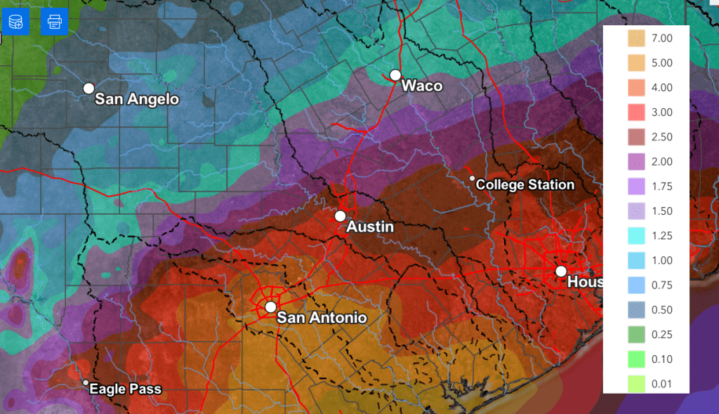
National Weather Service cumulative rainfall totals through Friday evening call for totals of 1-1.5 inches across the western half of the Hill Country, and totals of 2-4 inches across the eastern Hill Country and most of Central Texas. Totals of 3-5 inches are forecast across the middle Texas coast. Totals greater than 5 inches will be possible across the coastal plains region.
NWS Rainfall Forecast Valid through 7 pm Friday:
Rains Thursday into Friday have the potential to cause a localized flood threat across the Hill Country and Central Texas regions. There will be an increased threat for flooding and flash flooding for area along and south of Interstate 10, where higher amounts of rain are forecast.
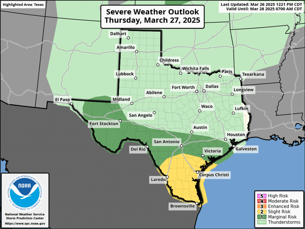
There will also be some potential for a few strong to severe thunderstorms Thursday through Friday afternoon. The Storm Prediction Center has placed parts of the region under a Marginal Risk, or 1 out of 5 risk, for severe storms on both days. The primary severe weather risks will be large hail and damaging downburst winds.

I urge everyone to keep up with weather developments over the next couple of days. Have multiple ways of receiving watches and warnings from the National Weather Service.
Bob
Social Media