A weekend cold front brought an end to last week’s stretch of unusually warm weather. Monday’s weather is predicted to remain cloudy and cool as a weak overrunning pattern sets up. Some spotty drizzle will be possible, but no significant rain is forecast. Monday’s high temperature will range from around 50 degrees across the Hill Country, to the low 50s in the Austin area, near 60 near La Grange, to near 70 degrees towards the coast.
Light to moderate rain showers and isolated thunderstorms are forecast to develop across the Edwards Plateau Monday evening in advance of a trough of low pressure slowly lifting northeast out of northern Mexico. The area of rain and thunderstorms is predicted to spread east across the Hill Country and Central Texas regions Monday night, then continue across the area through Tuesday afternoon. For the coastal region, rain showers and scattered thunderstorms are forecast to develop after daybreak Tuesday and continue through late afternoon. The chance for rain should temporarily decrease Tuesday evening.
A second wave of light to moderate rain showers and scattered thunderstorms is forecast to spread across the region beginning late Tuesday evening through Wednesday morning when a second wave of low pressure lifts northeast out of Mexico. The chance for rain should end by midday Wednesday as the wave of low pressure exits to the northeast. The sky is predicted to become partly cloudy Wednesday afternoon.
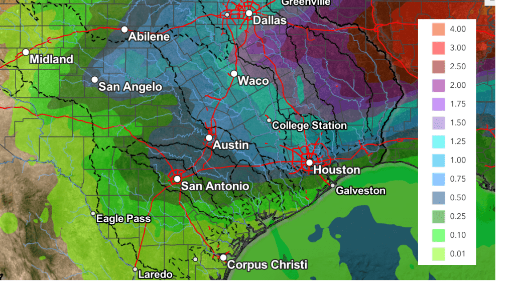
The threat for strong to severe thunderstorms from both waves of low pressure will be quite low. The highest totals of rain through Wednesday are forecast to be across the eastern Hill Country and most Central Texas, where totals should generally average between 0.5 and 1 inch. Lower totals are expected elsewhere.
NWS Rainfall Forecast for the Period 6 pm Monday through 6 pm Wednesday:
There will be quite a bit of change in the temperature Tuesday into Wednesday. A strong cold front is forecast to push south across the area Wednesday afternoon, bringing much colder air beginning Wednesday night. A light freeze is forecast for the Hill Country region Wednesday night and Thursday night.
- Lows Tuesday morning will range from the low 50s across the Hill Country, to the low 60s across the coastal plains
- High temperatures Tuesday are forecast to range from the low 60s across the Hill Country, to the mid and upper 70s across the coastal area
- Low temperatures Wednesday morning are forecast to be in the low 50s across the Hill Country, the mid-50s across Central Texas, and the upper 60s coastal region
- High temperatures Wednesday will range from the upper 60s across the Hill Country, to the mid-70s across Central Texas, to the low 80s across the coastal plains.
- Lows Thursday and Friday mornings are forecast to be in the upper 20s to low 30s across the Hill Country, the mid-30s across Central Texas, and the low 40s across the coastal region
- High temperatures Thursday will include the mid and upper 40s across the Hill Country and Central Texas regions, with low and mid 50s towards the coast
- High temperatures Friday will range from the upper 50s Hill Country to the mid-60s towards the coast
A ridge of high pressure spreading in from the west will bring dry weather and a partly cloudy sky Thursday through Friday.
There will be a very slight chance for a few light rain showers Saturday when another Canadian cold front pushes south across the area Saturday afternoon. Rain amounts, if any, should only total a few hundredths of an inch. The temperature will turn noticeably colder behind the front Saturday night through Sunday night. Another light freeze is forecast fort the Hill Country both Sunday and Monday morning.
- High temperatures Saturday are forecast to generally be in the mid-70s
- High temperatures Sunday are predicted to be in the mid and upper 50s
- Low temperatures Sunday and Monday mornings will include the upper 20s to low 30s across the Hill Country, the mid-30s across Central Texas, and the upper 30s to low 40s across the coastal plains
Looking out into next week, forecasts call for generally dry weather Monday and Tuesday as another ridge of high pressure spreads over Texas out of the west. A chance for rain showers looks to develop next Wednesday and Thursday when a trough of low pressure swings across Texas out of the Desert Southwest. As of now, only low rain amounts are expected. Temperatures next week are forecast to be mild, with highs in the 60s and lows in the 40s.
Have a great week!
Bob
Social Media