Welcome to the start of June! The month of May turned out to be a wet month across most of Texas. Rainfall was 1-3 inches above normal across most of the Hill Country, the middle Texas coast, and most of Central Texas. Interestingly, the area between Temple, Austin, and San Marcos saw totals that were slightly below normal. According the LCRA’s Hydromet, the highest gauged total for May was 11.16 inches, at a location 3 miles north-northeast of Mason, in Mason County. Doppler radar estimates show much of southwestern Colorado County received more than 10 inches of rain.
The wet weather pattern we saw in May weakened toward the end of the month as a weak ridge of high pressure built north out of Mexico. However, a chance for widespread rain will return to the forecast Sunday through Tuesday when the ridge weakens and a series of low pressure troughs moves into Texas out of Mexico. Some locally heavy downpours will be possible. A slight chance for rain will continue next Wednesday and Thursday.
Long-range forecasts point toward dry and warmer weather late next week and next weekend as the ridge of high pressure returns to Texas.
Here’s a breakdown of the weather for the next week:
This Afternoon through Friday Afternoon
Mostly sunny and dry weather is forecast as a weak ridge of high pressure remains over the region. A few isolated rain showers or thunderstorms will be possible across the coastal plains region both afternoons, but areal coverage will be quite low. Most locations will remain dry.
High temperatures both days are predicted to be near 88-90 degrees. A few spots along the Interstate 35 corridor could reach the low 90s.
Friday Evening through Saturday Afternoon
A wave of low pressure lifting northeast out of northern Mexico is expected to cause the development of scattered strong to severe thunderstorms across parts of West Texas late Friday afternoon into Friday evening. Some of these storms may be strong to severe, producing large hail and damaging winds. A few of these storms are forecast to spread east to the Edwards Plateau and the western Hill Country late Friday evening into Friday night. Here, the probability for rain will be near 30 percent, and rain amounts should total around a half inch, with isolated totals of 1-2 inches. This activity is forecast to diminish late Friday night.
Saturday’s weather is shaping up to be mostly sunny and hot. Expect high temperatures in the low 90s at most locations.
Saturday Night through Tuesday
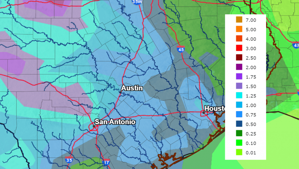
A series of small waves of low pressure are forecast to track into Central and South Texas out of northeastern Mexico during this period. With abundant moisture in place, periods of showers and thunderstorms are forecast across the region. The probability for rain will be around 30 percent Saturday night, and near 50 percent Sunday through Tuesday. There will be a potential for some locally heavy downpours throughout the period. Forecasts call for rain amounts to generally average around a half inch each day, with isolated heavier totals.
NWS 5-Day Rainfall Forecast for the Period 7 pm Thursday through 7 pm Tuesday
Daily high temperatures Sunday through Tuesday are forecast to be in the upper 80s.
Next Wednesday through Thursday
With lingering moisture in place, there will be a slight chance for scattered mainly afternoon and evening showers and thunderstorms across the region. Daily rain amounts are forecast to be only around a tenth of an inch. Otherwise, expect a mostly sunny sky and warm temperatures, with highs near 90-92 degrees.
Friday into Next Weekend
Mostly sunny, dry, and hot weather is forecast as a ridge of high pressure develops across Texas and the southern Plains states.
Expect daily high temperatures to be in the low to mid-90s.
Tropical Weather Update
Today, June 1st, marks the official start to the Atlantic Hurricane Season.
Recent satellite wind data, along with buoy and ship observations indicate the area of low pressure over the northeastern Gulf of Mexico has a broad but well-defined circulation with maximum sustained winds of about 35 mph. Shower and thunderstorm activity associated with the low is also showing signs of organization. Environmental conditions remain marginally favorable for additional development, and if these trends continue, a short-lived tropical depression or tropical storm is likely to form as soon as Thursday afternoon. The system is likely to meander over the northeastern Gulf of Mexico through tonight, but begin a slow southward motion on Friday. By this weekend, environmental conditions are forecast to become unfavorable for additional development as the system continues moving southward, likely remaining offshore over the Gulf of Mexico. An Air Force Reserve Hurricane Hunter aircraft is scheduled to investigate the system later this afternoon.
NHC forecasters are giving this system a 70 percent chance for tropical development over the next 48 hours.
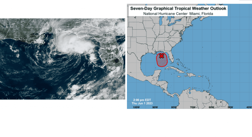
This developing system poses no threat to the western Gulf or the Texas coast.
Elsewhere, there are no systems in place which pose a threat for tropical development over the next seven days.
June’s Full Strawberry Moon
The June full moon will take place Saturday morning at 6:39 am CDT. This means the moon will appear full both Friday night and Saturday night.
June’s full moon is traditionally called the Strawberry Moon, marking the time of year when these delicacies ripen for harvest.
The June full moon is also known as the Mead Moon, the Rose Moon, and the Honey Moon because of the apparent color of its disk. It is the southernmost full moon of the year and because its light has to pass through more of Earth’s atmosphere for us in the Northern Hemisphere, it takes on a slight amber tint.
Bob
Social Media