- A line of thunderstorms is forecast to develop across the Hill Country shortly after 4 pm. This line of storms is expected to move into the Austin and Interstate 35 corridor area between 6 pm and 9 PM and the coastal plains region between 9 pm and midnight.
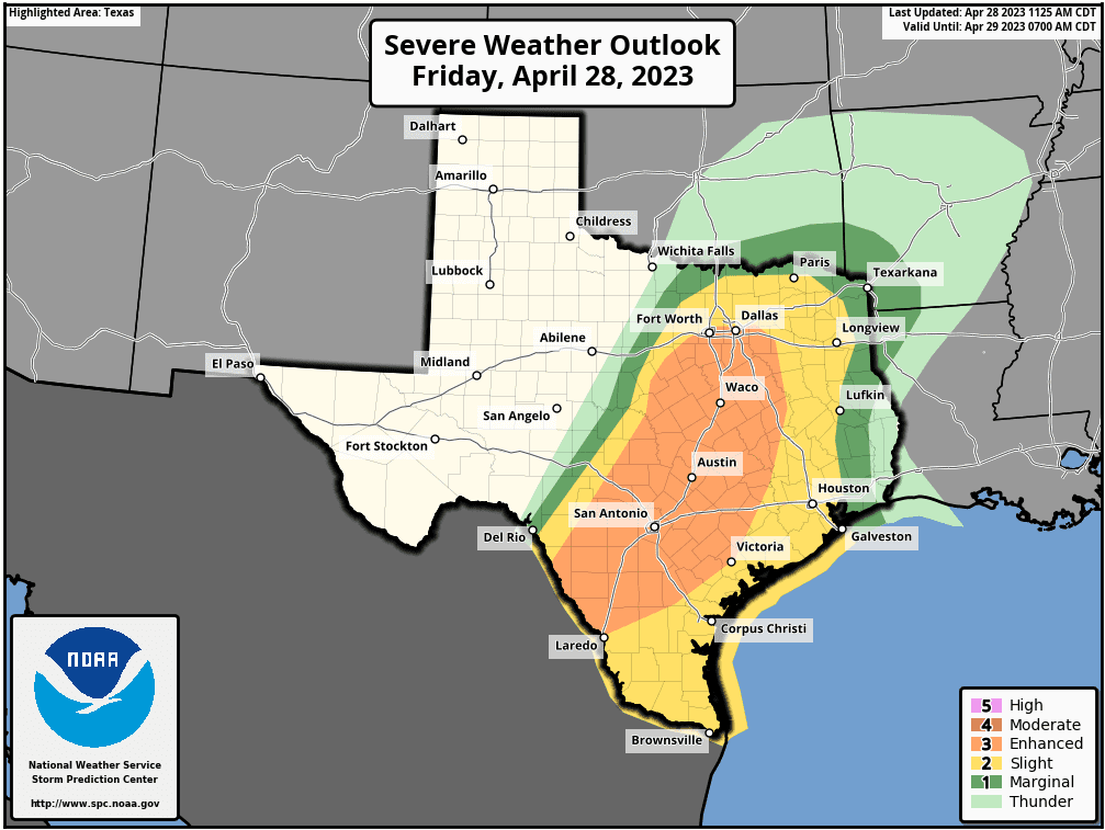
- The Storm Prediction Center has placed most of our region under an Enhanced Risk for severe thunderstorms with this line of storms. This is a level 3 out of 5 risk. Damaging straight-line wind gusts, large hail and an isolated tornado or two will be possible from this line of storms.
- Today’s storms are not expected to produce high totals of rain as they will be moving too quickly. However, some isolated pockets of moderate to heavy rain will be possible for areas along and east of Interstate 35.
- Given the potential timing of storms during the late afternoon into the Friday evening commute, those with travel plans should pay close attention to the radar and any potential watches and warnings.
- Be weather aware! Make sure you have multiple sources to receive National Weather Service watch and warning information.
Discussion
Moisture is quickly returning off the Gulf of Mexico ahead of a trough of low pressure that is tracking southeast our of New Mexico. Ahead of the trough, atmospheric conditions across the Hill Country and Central Texas are forecast to become increasingly unstable throughout the afternoon. High-resolution forecast solutions call for a broken line of thunderstorms to develop around mid-afternoon across the Hill Country along a southeastward-moving cold front. These thunderstorms are predicted to quickly become severe, capable of producing hail in excess of 2 inches in diameter and downburst winds in excess of 75 mph. A couple isolated thunderstorms will also be possible. The area of thunderstorms is forecast to grow into a more solid line of thunderstorms before it exits the Hill Country and moves into the I-35 corridor. The line of rain and thunderstorms is then expected to continue moving to the southeast over the course of Friday evening, pushing off the middle Texas coast shortly after midnight.
The Storm Prediction Center is noting an Enhanced Risk for severe thunderstorms across the eastern Hill Country and all of Central Texas. SPC forecasters have placed the western/central Hill Country and the middle Texas coast under a Slight Risk for severe thunderstorms.
Do to the quick movement of this line of thunderstorms, widespread heavy rainfall is not expected. Totals across the Hill Country are forecast to average around a quarter inch, or less. Across Central Texas and the middle Texas coast, totals are forecast to average between 0.5 and 1 inch, with isolated totals of 1-2 inches possible.
Behind the cold front, windy conditions are forecast to develop. Expect northwesterly winds with speeds of 15-25 mph, and gusts to around 40/45 mph. Similar wind speeds look to continue through Saturday afternoon, with the wind decreasing to 10-15 mph Saturday evening.
Sunny and dry weather will be in place this weekend. The temperature will trend cooler Friday night and Saturday, then trend back warmer on Sunday.
- Lows Saturday morning will range from 50 degrees across the Hill Country, to the upper 50s near the coast.
- High temperatures Saturday will be in the low 70s.
- Lows Sunday morning will generally be in the upper 40s, with low 50s towards the coast.
- High temperatures Sunday are forecast to be in the low 80s.
- Lows Monday morning will be in the mid and upper 50s.
Mostly sunny, dry and warm weather is predicted next Monday through Wednesday as a ridge of high pressure spreads over Texas. Expect daily high temperatures in the mid-80s, with low temperatures in the 60s.
Forecasts point toward more clouds and a slight chance for rain showers and isolated thunderstorms late next week as the ridge weakens and moisture increases off the Gulf. Rain amounts, if any, look to be quite low. No significant change in the temperature is expected.
Bob
Social Media