There will be a potential for strong to severe thunderstorms across the eastern Hill Country late this afternoon, with another potential for strong to severe storms across the eastern Hill Country and parts of Central Texas late this evening till just after midnight. A slight chance for showers and isolated thunderstorms will continue through the weekend, along with quite a bit of sunny weather as well. Next week’s weather will include a slight chance for showers and thunderstorms Monday through Wednesday, but no significant totals of rain are forecast.
Temperatures will trend a little cooler over the weekend and into Monday, but warmer readings return for the balance of next week. In fact, high temperatures are forecast to be in the low to mid-90s over the Memorial Day weekend.
Here’s a breakdown of expected weather conditions over the next week:
Friday Afternoon through Friday Night:
Forecasters will be closely monitoring the Hill Country and the Concho Valley regions for thunderstorm development mid to late afternoon. Scattered thunderstorms are forecast to develop along a surface trough of low pressure located across the Concho Valley region by about mid-afternoon. Should thunderstorms develop, atmospheric conditions will be favorable for these storms to quickly become severe as they move southeast over the area between Brady, Menard, Mason, and Burnet. The primary severe weather threats will be damaging downburst winds and large hail. These particular storms are forecast to diminish before sunset.
There will be a second threat for strong to severe storms across the Hill Country and into parts of Central Texas this evening, continue past midnight as a cold front moves southeast out of Northwest Texas. High resolution forecasts call for an area of showers and thunderstorms to develop out ahead of and along the advancing cold front. Forecasts call for a large area of rain and thunderstorms to develop across the Hill Country through the evening hours, with the activity slowly shifting south and southeast toward the I-35 corridor a little before midnight, and across the rest of Central Texas after midnight. Once again, the primary severe weather threats will be damaging downburst winds and large hail. The threat for tornadoes appears low.
Forecasts call for most of the showers and storms to dissipate late tonight before reaching the coastal plains.
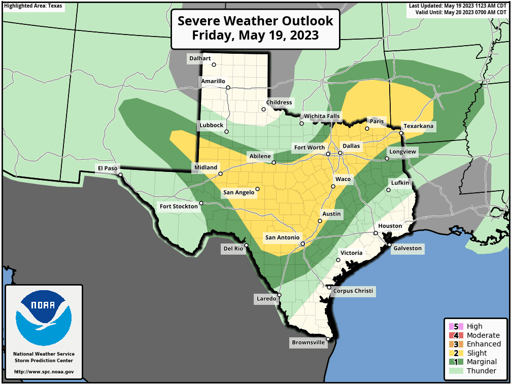
The Storm Prediction Center has placed all of the Hill Country, plus the Interstate 35 corridor including the Austin metro, under a 2 out of 5 risk for severe thunderstorms Friday afternoon through Friday night. The area between Austin and La Grange has been placed under a 1 out of 5 risk for severe thunderstorms.
Rain amounts from showers and thunderstorms late this afternoon and overnight are forecast to generally average between 0.5 and 1 inch across the Hill Country. However, isolated totals of 1-3 inches will be possible at several locations. Across Central Texas, rain amounts are forecast to average around a quarter inch.
It’s going to be a warm one across the region Friday, with high temperatures near 90-93 degrees. Lows Saturday morning will range from the low 60s across the northern Hill Country, to the upper 60s near the coast.
Saturday through Sunday
Friday’s cold front is forecast to slowly move past Austin after daybreak Saturday, then reach the middle Texas coast around sunset. A slight chance for a few isolated showers and thunderstorm will continue across the Hill Country and Central Texas regions Saturday afternoon, but rain totals, if any, should total less than a tenth of an inch. Expect a partly to mostly cloudy sky. High temperatures will be in the low 80s across the Hill County and Central Texas, and in the upper 80s near the coast.
There will be a 20-30 percent chance for scattered rain showers and thunderstorms across the Hill Country and Central Texas regions Sunday when a weak wave of low pressure tracks northeast out of Mexico. Rain amounts, if any, should total less than a quarter inch. Expect a partly cloudy sky throughout much of the day. High temperatures are forecast to be in the upper 70s to low 80s. Lows Monday morning will be in the upper 50s to low 60s.
Monday through Friday
Sunny and dry weather will be in place Monday. Expect high temperatures in the mid-80s.
Expect a mostly sunny to partly cloudy sky Tuesday through next Friday as a large ridge of high pressure build north from Mexico across West Texas and into the southern Rockies. A northwesterly wind flow in the middle and upper atmosphere on the eastern side of the ridge will have the potential to bring occasional disturbances into the eastern half of Texas, resulting in a few showers and thunderstorms. As of now, the best chance for rain will be on Tuesday, with the probability being around 30 percent. Otherwise, expect just a 20 percent chance for late afternoon showers and thunderstorms Wednesday through Friday. Rain amounts should total under a quarter inch.
Warmer temperatures will be returning. Expect high temperatures in the upper 80s Tuesday and Wednesday, and into the low 90s Thursday and Friday.
Memorial Day Weekend
A early look into Memorial Day weekend calls for a partly cloudy sky and just a slight chance for afternoon showers and thunderstorms. Temperatures are looking somewhat toasty, with highs forecast to be in the low and mid-90s throughout the weekend.
Have a good weekend.
Bob
Social Media