Scattered Showers Possible through Saturday. Seasonably Hot Temperatures Next Week
July 12, 2024
The atmosphere is forecast to be somewhat unstable as we head into the weekend, thanks to an area of low pressure situated over northern Mexico. For the past couple of days, this same area of low pressure, in combination with a zone of tropical moisture, has led to the development of scattered showers and thunderstorms across South Texas—mainly along and to the south of Interstate 10. The showers produced spotty totals of 0.25 to 0.5 inches. Friday morning, a persistent area of rain over eastern Fayette and Austin Counties produced an area of 1-2 inch rain totals.
A similar pattern of scattered mainly afternoon and evening showers and thunderstorms is forecast to continue Friday and Saturday. For these two days, the chance for rain is predicted to expand north to also include all of Central Texas and the eastern half of the Hill Country. The probability for rain will range from 50-60 percent across the coastal plains, to near 30 percent across Central Texas and the eastern Hill Country. For locations that happen to see rain, amounts on both days are forecast to generally average between a quarter and a half inch, with some very isolated totals of 1-2 inches possible.
- High temperatures Friday and Saturday will include the mid and upper 90s across the Hill Country and Central Texas regions, and the upper 80s to low 90s across the coastal plains.
For Sunday and the first half of next week, the chance for additional scattered rains across Central Texas and the Hill Country will decrease as the zone of tropical moisture shifts south to the coastal plains. Weather conditions look to be mostly sunny, dry, and hot, with just a few isolated showers possible across the coastal region.
- High temperatures Sunday through Wednesday are forecast to be near 98-100 degrees across the Hill Country and Central Texas regions, and in the mid-90s across the coastal plains.
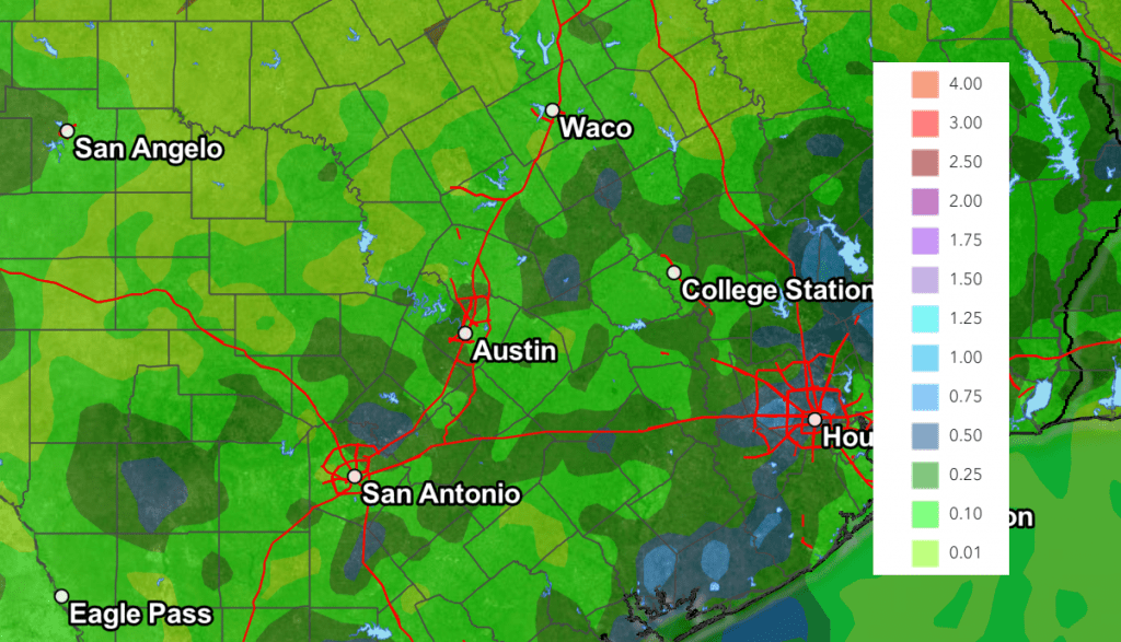
NWS Rainfall Forecast for the Period 7 pm Friday through 7 pm Wednesday:
Looking out into late next week and next weekend, forecasts show a chance for scattered showers and thunderstorms returning to the forecast as weak cold front sags south into Texas. Forecasts call for the front to make it into North Texas, and possibly as far south as Central Texas. The cold front and associated outflow boundaries will have the potential to cause showers and isolated thunderstorms across the region beginning next Thursday, continuing into next weekend. Unfortunately, there’s currently too much uncertainty in the strengthen and position of the front to get a handle on how much rain the front may bring to our area. Cold fronts in July, even weak ones, are not all that common and come with lots of uncertainties.
High temperatures late week and next weekend are forecast to generally stay near 98-100 degrees.
Tropical Weather Outlook
In the wake of Hurricane Beryl, conditions have turned very quiet across the tropical Atlantic.
National Hurricane Center forecasters are monitoring an area of disorganized showers and thunderstorms located near the North and South Carolina coastlines. Strong upper-level winds over the area will limit any development of this system before it moves inland over South Carolina and North Carolina Friday evening. However, the disturbance could contribute to areas of heavy rainfall and possible flash flooding across coastal portions of the Carolinas and Mid-Atlantic through Friday night. NHC forecasters are giving this system a zero percent chance for development over the next 48 hours.
Elsewhere, there are no systems in place which pose a threat for tropical development for the next seven days.
Have a great weekend and stay cool!
Bob
Social Media