Here’s an update on the arctic air that will begin spreading into our region Saturday night and the threat for wintery precipitation early next week. Confidence has increased in the development of wintery precipitation across Central Texas and the middle Texas coast Monday night into Tuesday. In addition, the temperature forecast for Tuesday night has trended slightly colder.
Weather Highlights:
- Very cold air will arrive Saturday evening and remain across the area through next Thursday
- Windy conditions will develop Saturday evening and persist into Tuesday. Expect gusts to near 30 mph.
- Low temperatures Wednesday morning are forecast to be in the mid and upper teens across the Hill Country and close to 20 degrees at most other locations
- Confidence in the development of wintery precipitation across Central Texas and the middle Texas Monday night into midday Tuesday has increased to between 60 and 70 percent.
- A Winter Storm Watch has been posted for areas along and south of Interstate 10 Monday evening through Tuesday afternoon
Discussion
The much anticipated outbreak of arctic air will begin to be felt Saturday night when much colder air spreads into the region behind an arctic cold front. The arctic cold is forecast to remain in place through Wednesday and will bring our region several periods of hard freezes. Northerly winds will increase to a range of 10-15 mph, with occasional gusts to 30/35 mph Saturday night, with continued breezy conditions expected to continue into Tuesday. The combination of the strong winds and the very cold air will produce wind chill temperatures into the teens Sunday, Monday, and Tuesday mornings. Due to these very chilly temperatures, the National Weather Service has posted a Cold Weather Advisory for the region from midnight Saturday night till 9 am Saturday. The advisory will likely be extended into next week.
Sunny, dry and cold weather is forecast Sunday. The sky looks to become cloudy Monday afternoon and remain cloudy through Tuesday afternoon. Clouds should clear Tuesday night, followed by a mostly sunny sky next Wednesday through Friday.
An update on low temperatures forecast through late next week:
- Sunday morning: Low and mid-20s Hill Country, upper 20s Central Texas, and lower 30s coastal area
- Monday morning: Upper teens across the Hill Country, 20-24 degrees across Central Texas, mid and upper 20s coastal plains
- Tuesday morning: Low 20s Hill Country, mid-20s across Central Texas, and upper 20s coastal plains
- Wednesday morning: Between 15 and 20 degrees across the Hill Country and Central Texas regions, and in the low 20s coastal plains
- Thursday morning: Mid-20s across the entire region.
Although the precipitation forecast remains a bit of a challenge, all of the forecast model guidance is now in agreement in calling for the development of wintery precipitation across the eastern Hill Country, Central Texas, and the middle Texas coast Monday night into Tuesday as Gulf moisture returns inland ahead of an approaching wave of low pressure. Forecasts call for the precipitation to begin sometime around midnight and continue overnight and into Tuesday morning.
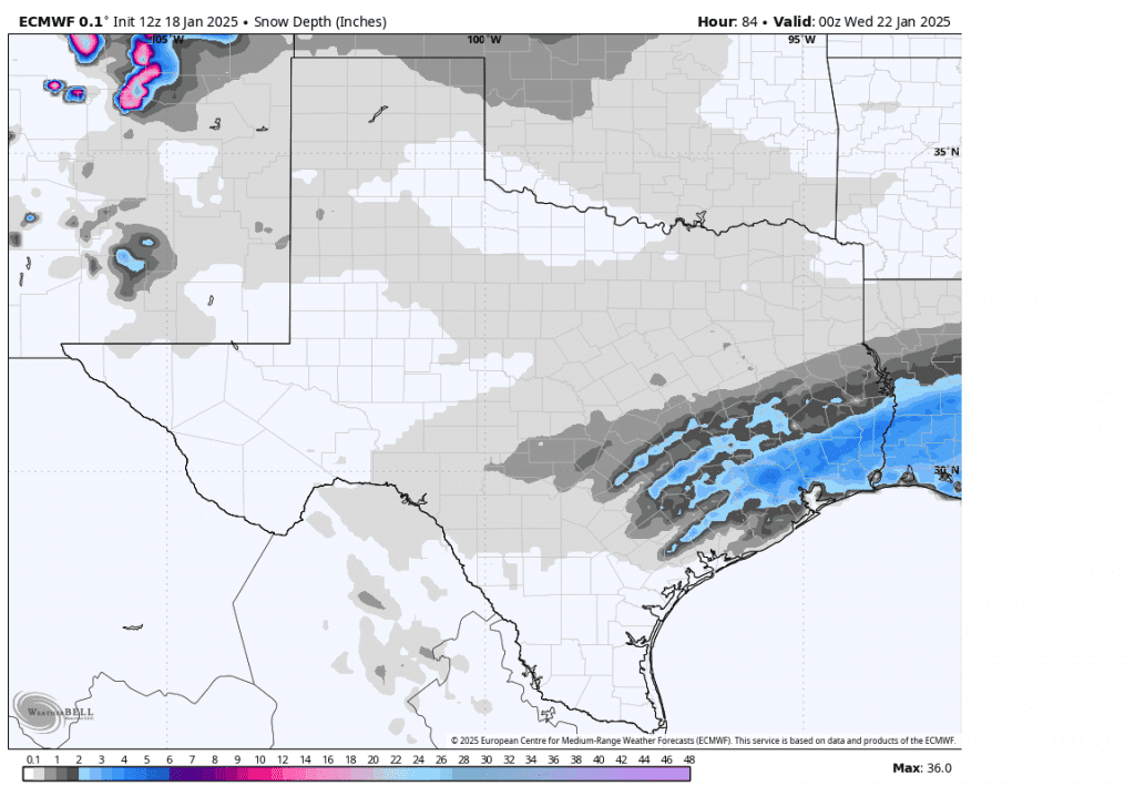
Forecasts call for the precipitation to start off as a mixture of light rain, freezing rain, sleet and snow showers. The majority of the precipitation is predicted to transition over to primarily snow showers across the eastern Hill Country and Central Texas regions late Monday night through about midday Tuesday. Ice accumulation across these two areas is forecast to range from a trace to just a couple hundredths of an inch. Snow accumulations are forecast to total around an 1-1.5 inches across much of Central Texas, while staying below an inch across the eastern Hill Country.
For areas south of Interstate 10, the precipitation is forecast to be heavier due to greater moisture. In fact, some of the guidance suggests the precipitation may set up in bands and will have the potential to produce heavy amounts of mixed precipitation. Rain, freezing rain, sleet, and snow showers are forecast to develop around midnight Monday night and continue into Tuesday afternoon. Widespread sleet/snow totals of 1-3 inches are forecast. Ice accumulations up to a tenth of an inch will be possible. The National Weather Service has posted a Winter Storm Watch for areas along and south of Interstate 10 from Monday evening through Tuesday afternoon. Roads, and especially bridges and overpasses, will likely become slick and hazardous. Plan on slippery road conditions. The hazardous conditions could impact the Tuesday morning and evening commutes.
Pasted below is the forecast accumulation of snow from the Saturday morning European forecast solution. I would use this as a guide to where the precipitation is forecast to fall and a feel for the different magnitudes of snow possible. Again, this is not an official forecast and just an idea from one of the forecast solutions. This forecast has the potential to change over the next couple of days.
Forecast snow depth through 6 pm Tuesday from the ECMWF model:

Continue to monitor the latest weather forecasts and updates.
Bob


Social Media