Monday started off rather chilly, with temperatures in the 30s and 40s. Parts of the Hill Country and Central Texas saw a light freeze. The coldest temperatures occurred across the northern and western Hill Country, from west of Junction, to Brady and Brownwood. Here, readings dipped into the mid and upper 20s. The coldest temperature on LCRA’s Hydromet was 24 degrees, at a gauge in southern Callahan County, near Cross Plains.
This week’s weather is starting off quiet, with considerable high-level clouds spreading across Texas out of Mexico. The clouds are being generate by a weak trough of low pressure located across northern Mexico. The clouds will cause a partly cloudy sky this afternoon, and a mostly cloudy sky Monday night. The clouds are predicted to thin out beginning around midday Tuesday as the trough of low pressure exits to the northeast. A partly cloudy sky is forecast to be partly cloudy Tuesday night, with the sky becoming mostly cloudy on Wednesday.
Readings are not predicted to be quite as cold Monday night.
- High temperatures Monday will include the low and mid-50s across the northern Hill Country, with upper 50s at most other locations.
- Lows Tuesday and Wednesday mornings are forecast to be in the upper 30s across the Hill Country, the upper 30s to low 40s across Central Texas, and the low 40s across the coastal plains.
- High temperatures Tuesday are forecast to be around 58-60 degrees.
- High temperatures Wednesday are forecast to be in the low and mid-60s.
Southerly winds are forecast to return to the region beginning Wednesday. As a result, somewhat milder weather will be in place for the second half of the week. Forecasters are monitoring the next upstream trough of low pressure that is forecast to move into California, the Four Corners and desert Southwest region Wednesday night, and the Panhandle/ Northwest Texas area Thursday. In advance of the trough, a return flow off the Gulf is forecast to strengthen Wednesday afternoon into Wednesday night, drawing Gulf moisture northward into the region. As a result, light overrunning showers are forecast to develop across the region beginning Wednesday night. Light showers and a slight chance for scattered thunderstorms is forecast late Wednesday night through Thursday afternoon. The chance for rain looks to diminish late Thursday into Thursday evening as a Pacific cold front brings in drier air.
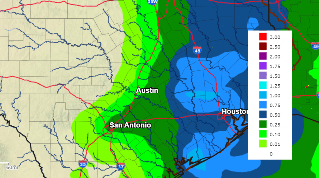
Rainfall between Wednesday evening and Thursday evening is predicted to be heaviest across the coastal plains region, and much lighter across the Hill Country and Central Texas. Totals are forecast to average less than a tenth of an inch across the Hill Country, bet between a quarter and a half inch across Central Texas, and be between a half and 1 inch across the coastal plains.
Do note there will be a low end chance for a couple of strong to severe thunderstorms for areas east of Interstate 35 Thursday afternoon. Forecasts show the best instability and strong/severe weather concern to be farther east in Louisiana. But that being said, a strong storm or two with hail and gusty winds will be possible.
NWS Rainfall Forecast for the period 6 pm Wednesday through 6 pm Thursday:
Sunny, dry, and mild weather will follow on Friday. Expect high temperatures in the mid and upper 60s.
Forecasts call for a second, deeper, trough of low pressure to sweep across the Central and Southern Plains over the weekend, bringing another chance for rain. With limited moisture in place, just a 20-30 percent chance for rain showers is forecast Saturday into Sunday morning. The rain is predicted to end from west to east Sunday afternoon. Weekend rain amounts are forecast to be remain under a quarter inch.
- High temperatures Saturday and Sunday are predicted to be in the mid and upper 60s. Lows Sunday and Monday mornings are predicted to be in the upper 40s to low 50s.
Looking ahead to next week, dry and mild conditions are forecast to be in place through most of the week as a ridge of high pressure spreads over the region out of the Desert Southwest. Expect high temperatures to be in the mid and upper 60s, with lows generally in the 40s. The next chance for isn’t expected until sometime late next week or the following weekend.
There are no signs of widespread freezing temperatures/arctic air headed towards our region through the middle of December.
Tropical Weather Update
Weather conditions are quiet across the tropical Atlantic as we enter the last few days of hurricane season. Tropical cyclone development is not expected over the next seven days.
Monday Night’s Near Full Moon Will Rise Farthest North
The Moon, just past full Tuesday night, will rise in the northeast sky in mid-twilight. But Monday’s night’s night will be special. Due to many factors involving the moon’s orbit around Earth, the Moon will be about as far north on the celestial sphere as you can ever possibly see it. As twilight fades Monday evening, note carefully where the Moon comes up over your horizon. You’ll probably never have seen it rise that far north over your landscape and you might never again, at least when it’s this close to full.
Bob
Social Media