Rain Ending Early Saturday. Sunny, Dry, and Mild through the Middle of Next Week
NOV. 8, 2024
A swath of heavy rain, averaging between 4 and 7 inches, fell across parts of Northwest Texas and the Concho Valley late Thursday night. Some of this rain also spread over the area between Coleman and Abilene, producing totals of 3-5 inches over the upper watershed of Pecan Bayou. The large area of rain is being generated by a vigorous low pressure system located over eastern New Mexico and an associated Pacific cold front.
The Hill Country and the Austin/Interstate 35 corridor regions will see an increasing chance for rain showers and thunderstorms Friday afternoon into Friday evening as the Pacific cold front slowly pushes to the east. Friday’s morning analysis showed a moist and moderately unstable atmosphere covering the region ahead of the cold front. The front is expected to become the focus for the development of a somewhat disorganized line of storms that will push east out of the Edwards Plateau. Forecasts call for the cold front to slowly push east across the Hill Country Friday afternoon, reaching the Austin/Interstate 35 corridor around 6-8 pm. Some pockets of locally heavy rain may develop due to the cold front moving so slowly. The probability for rain will be near 70-80 percent through Friday evening.
Do note there will be a low end threat for a few isolated strong to severe storms with the area of rain. The Storm Prediction Center has placed both regions under a Marginal Threat, or a 1 out of 5 threat, for severe thunderstorms through Friday night. The primary severe threats look to be large hail and damaging straight-line winds, although an isolated weak tornado cannot be totally ruled out.
The chance for rain is forecast to slowly taper off from west to east across the Hill Country late this afternoon, and across the Austin/I-35 corridor this evening. Rain amounts from the showers and thunderstorms are forecast to generally average between 0.5 and 1 inch, with a couple of isolated 2-3 inch totals possible.
For the eastern counties of Central Texas and the middle Texas coast, there will be a 50 percent chance for scattered rain showers and isolated thunderstorms this afternoon and evening in the moist and unstable atmosphere out ahead of the cold front. Rain amounts are forecast to average around a quarter inch. The chance for rain and scattered thunderstorms will continue overnight and into Saturday as the cold front slowly pushes east out of Central Texas. The threat for strong or severe storms appears low. Rain amounts Friday evening through Saturday afternoon are forecast to generally average between 0.25 and 0.5 inches. However, a coupe of locally heavy downpours cannot be ruled out. The rain is forecast to taper off across Central Texas Saturday morning, and across the coastal region around mid-afternoon Saturday.
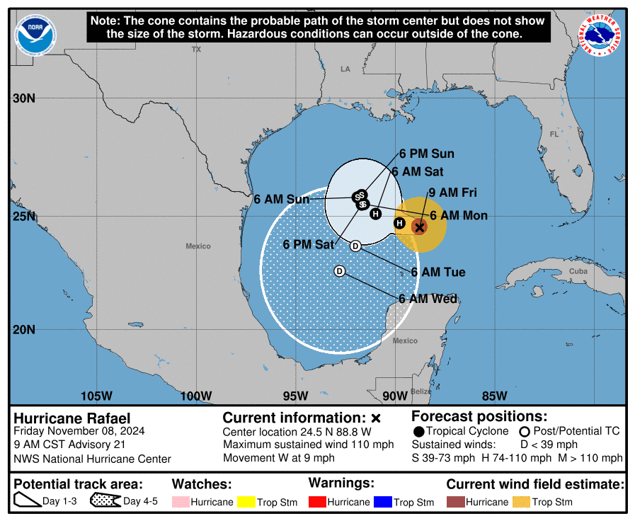
A mostly sunny sky is forecast Saturday in the wake of the cold front. There isn’t much cool air behind the front, but the air will be noticeably drier. Dry weather with a sunny to mostly sunny sky is forecast Saturday afternoon through the middle of next week as a weak ridge of high pressure spreads over Texas. Interestingly, the same cold front pushing south across Texas is also expected to help steer Hurricane Raphael to the west and southwest away from Texas over the coming days.
High temperatures Saturday are forecast to be in the mid and upper 70s. Highs Sunday through next Wednesday are forecast to be in the low 80s. Lows will range from the upper 40s and low 50s west, to the low 60s near the coast.
Forecasts call for another cold front to sweep across the area sometime late Wednesday or Thursday. As of now, no rain is expected with the front due to a lack of moisture. Sunny and slightly cooler weather should follow late next week. Expect highs to fall to the low 70s, with lows in the upper 40s to low 50s.
Tropical Weather Update
Hurricane Rafael has recently lost a little strength, but it remains a powerful hurricane. Rafael is moving westward at about 8 mph on the south side of a ridge of high pressure that extends across the western Atlantic and the east-central Gulf of Mexico. A slightly slower west-northwestward motion is expected during the next 24 hours or so as the ridge weakens. A trough approaching from the west should leave Rafael in very weak steering currents over the weekend and early next week, causing the system to meander over the central Gulf during that time. Once the system becomes weak and shallow, a turn to the south-southwest.
As of 9 am CST, the center of Hurricane Rafael was located about 535 miles east of the mouth of the Rio Grande River. Rafael was moving toward the west near 9 mph. A slower west-northwestward motion is expected during the next day or so. After that, Rafael is likely to meander over the central Gulf of Mexico through early next week.
Maximum sustained winds are near 110 mph with higher gusts. Steady weakening is expected during the next few days. Raphael is forecast to become just a remnant low pressure area early next week.

Have a great weekend!
Bob


Social Media