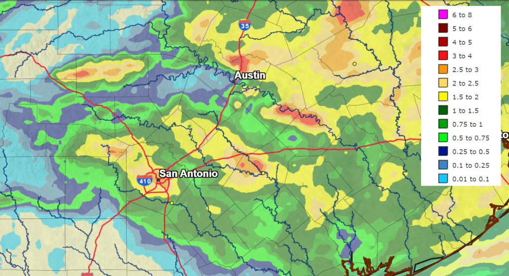
Rain showers and strong to severe thunderstorms developed across much of the region Thursday evening into Thursday night in advance of a slow-moving cold front. While severe weather wasn’t widespread, several locations recorded large hail and very strong winds. In addition, pockets of intense rain occurred across northern Travis County, western Gillespie County, and also eastern Bastrop and western Fayette Counties. These particular areas saw totals in the range of 3 to 4 inches. A CoCoRaHS reporter in northern Travis County, just west of Pflugerville, recorded a 24-hour total of 5.61 inches.
In general, the rains missed the western and northern Hill Country, where little to no rain was reported. Most of Central Texas and the middle Texas coast saw totals in the range of 0.5 to 1.5 inches.
NWS Estimate of Rain Falling Between 9 am Thursday and 9 am Friday:
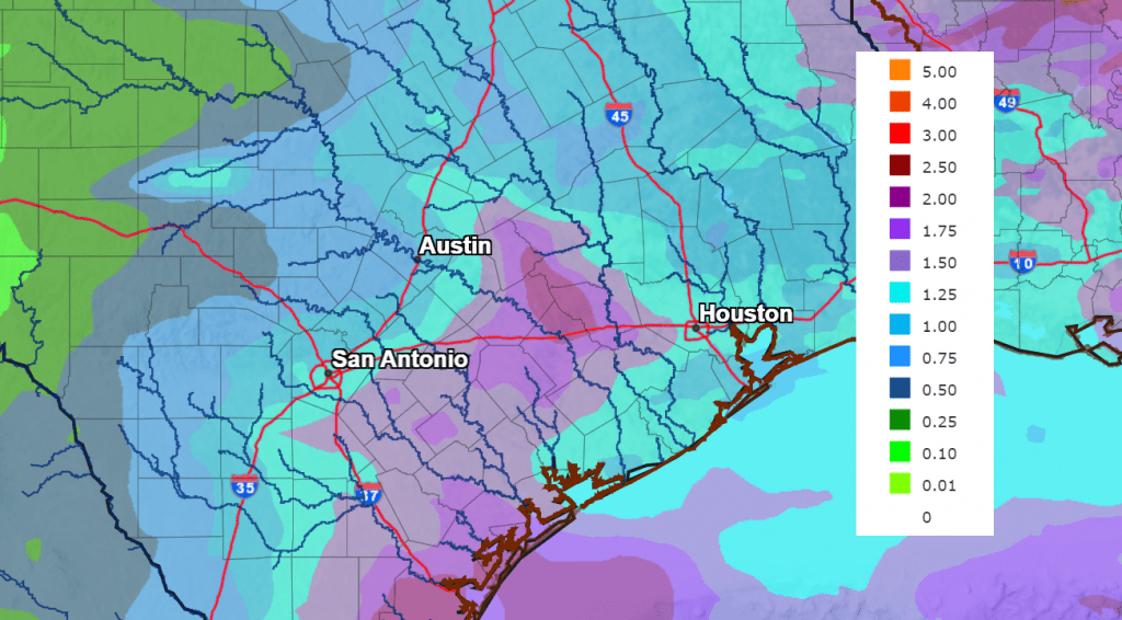
A short period of dry weather will be in place this afternoon through Saturday afternoon. However, another period of wet and unsettled weather is forecast to develop late Saturday night, and continue through the middle of next week. Several periods of rain and thunderstorms are expected. Over this upcoming period, more of the rain is predicted to fall across the western, central and northern Hill Country than we’ve seen as of late. Rain forecasts through late next week call for widespread totals of 1-2 inches.
Temperatures over the next week are predicted to be mild, with highs mostly in the 70s.
Here’s a breakdown of the outlook over the next week:
This Afternoon through Saturday Afternoon
The chance for additional rain and storms has ended across the Hill Country and Central Texas. Look for the sky to clear from northwest to southeast this afternoon. Across the coastal plains, lingering moisture and instability will lead to a 30 percent chance for scattered rain showers and isolated thunderstorms through late afternoon. Rain amounts, if any, should total less than a tenth of an inch.
The cold front is predicted to move off the middle Texas coast early this evening, with drier and slightly cooler air spreading in behind the front. Expect a clear sky Friday night, and a mostly sunny sky Saturday.
- High temperatures Friday and Saturday are forecast to be around 78-80 degrees.
- Lows Saturday morning are predicted to be in the low 50s across the Hill Country and Central Texas, and in the mid to upper 50s near the coast.
Saturday Night through Sunday Night
A chance for rain showers and isolated thunderstorms will return to the forecast by about midnight Saturday night. This will be in advance of a trough of low pressure tracking southeast out of New Mexico. Showers and scattered thunderstorms are predicted off and on throughout the day Sunday, with the activity continuing into Sunday evening. While widespread severe storms are not expected, some of storms Sunday afternoon could produce some large hail. The probability for rain will be 30 percent Saturday night and 60 percent Sunday and Sunday evening. The chance for rain should diminish around midnight Sunday night.
Rain amounts through Monday morning are forecast to generally average between 0.5 and 1 inch, with isolated heavier totals—mainly across the coastal plains.
- Lows Sunday and Monday mornings are forecast to be in the low and mid-50s.
- High temperatures Sunday are forecast to be in the mid-60s.
Monday through Thursday
A wet and unsettled pattern will continue. Forecasts call for additional troughs of low pressure to track southeast over the area late Monday into Tuesday and also on Wednesday into Thursday. Periods of rain showers and scattered thunderstorms are forecast Monday through Thursday, with the probability for rain around 50 percent. Some of the storms on Monday and Tuesday may be strong to severe.
Rain amounts each day are forecast to average between 0.25 and 0.5 inches.
- High temperatures are forecast to be in the upper 60s Monday, warming to the mid-70s Tuesday through Thursday
- Low temperatures are forecast to be in the upper 50s to low 60s.
Next Friday through Next Weekend
Mostly sunny and dry weather is forecast. Expect high temperatures in the low 80s, with low temperatures will be in the low 60s.
NWS 7-Day Rain Forecast
NWS Rainfall Forecast for the Period 7 pm Friday through 7 pm Next Saturday:
2023 Lyrid Meteor Shower
The Lyrid meteor shower is upon us. Late evening to dawn on the nights of April 21-22 and April 22-23 will be the best time to watch. The predicted peak to the shower is expected early Sunday morning. This year, the moon won’t interfere with trying to see the Lyrids. The point in the sky from which the meteors radiate – called the radiant point – will rise before midnight in the northeastern sky, and is highest in the sky at dawn. Expected meteors at peak, under ideal conditions will be around 10 to 15 Lyrids per hour. The Lyrids are known for uncommon surges that can sometimes bring rates of up to 100 per hour!
Have a good weekend!
Bob
Social Media