Sunny and very quiet weather continues in the wake of last week’s heavy rain and blast of cold air. We’re now at the start of a warming trend that will continue into the middle of next week. Light southerly breezes returned to the region late Thursday and this helped keep temperatures a little warmer Thursday night. Lows Friday morning were generally in the 40s and 50s, with very few 30s recorded across the Hill Country.
Our quiet weather pattern can be attributed to the storm track lifting north to the Canadian border earlier in the week. Meanwhile, a large, stable ridge of high pressure located over northern Mexico and the Southwestern is currently spreading east across Texas. The ridge is predicted to stick around into the middle of next week, and looks to keep the weather pattern generally sunny, dry, and quiet.
Southerly breezes with speeds of 5-10 mph are forecast this afternoon, continuing through Sunday night.
The temperature will be trending warmer over the next 2-3 days.
- High temperatures Friday are forecast to be in the low and mid-70s.
- Highs Saturday are forecast to be near 78-80 degrees.
- Highs Sunday are forecast to be near 80 degrees.
- Highs Monday are forecast to be in the low and mid-80s.
- Highs Tuesday and Wednesday are forecast to be in the upper 80s.
- Lows Saturday morning are predicted to be in the low and mid-50s
- Lows Sunday morning are predicted to be in the mid and upper 50s.
- Lows Monday morning are predicted to be in the low 60s.
- Lows Tuesday through Thursday morning are predicted to be in the low and mid-60s.
Some patchy fog will be possible across parts of Central Texas and the middle Texas coast Saturday and Sunday mornings.
Looking out into late next week and next weekend, changes in the weather pattern look to take place. Forecasts call for a Canadian cold front to push south across the area Thursday afternoon and Thursday night, bringing a push of cooler air. Scattered showers and thunderstorms are forecast to develop along the cold front. An overrunning pattern of clouds and rain is then forecast to develop behind the cold front next Friday through next weekend as a Pacific trough of low pressure slowly pushes inland across the western U.S. Rain amounts are uncertain at this point, but some forecast solutions are pointing toward to totals of at least an inch.
Readings will trend cooler behind Thursday’s cold front, with highs falling to the 60s, and lows staying mostly in the 50s.
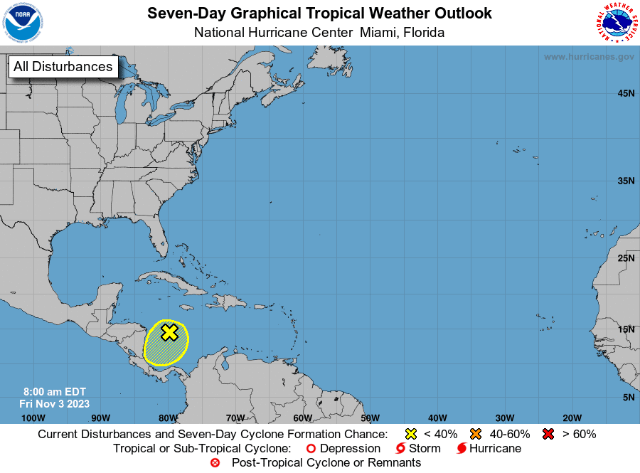
Tropical Weather Update
Weather conditions are quiet across the Gulf of Mexico and should remain quiet for the next seven days.
Across the central Caribbean Sea, forecasters continue to monitor an area of disorganized showers and thunderstorms associated with a trough of low pressure. NHC forecasters feel environmental conditions could become a little more conducive for tropical development with this system in a day or two, and a tropical depression could form when the system moves over the southwestern Caribbean Sea late next week.
NHC forecasters are giving this system a 50 percent chance for tropical development over the next seven days.
Time Change this Weekend
Sunday morning at 2 am, daylight saving time will end and we will move back to central standard time. Remember to “fall back” Saturday night, and set your clocks back one hour before bedtime.
Have a good weekend!
Bob
Social Media