Periods of Rain and Thunderstorms Can be Expected through Saturday
SEPT. 14, 2023
Wednesday night, an area of rain showers and thunderstorms spread east across the region along a wave of low pressure. Most totals averaged around a quarter inch or less. However, an area of very rain was observed across northern Travis and southern Williamson Counties, where a narrow band 3-4 inch totals were observed.
This afternoon, Doppler radar showed quiet conditions across the Hill Country and Central Texas regions, while scattered showers and thunderstorms continued across the middle and upper Texas coast. Despite the current lull in the rain, the weather pattern remains unsettled, and additional periods of rain showers and thunderstorms are forecast between Thursday evening/Thursday night and Saturday night.
Forecasters are monitoring the next wave of low pressure that is currently located over northern Mexico and moving to the east. This feature is forecast to spread across the Hill Country, Central Texas and the middle Texas coast this evening and overnight. Atmospheric parameters suggest some of these storms may potentially be strong to severe. The Storm Prediction Center has placed our region under a Marginal Risk, or 1 out of 5 risk, for severe thunderstorms through 7 am Friday. Damaging downburst winds and large hail will be possible with some of the thunderstorms. Rainfall from this next round rain and storms is forecast to generally average between 0.25 and 0.5 inches. However, isolated totals of 2-4 inches will be possible.
Additional periods of rain and thunderstorms are forecast Friday through Saturday night as more waves of low pressure move in from the west. However, the timing of these next rounds of rain and thunderstorms will be difficult to nail down due to the uncertainty in the position of a surface boundary and model resolution of the upstream waves of low pressure.
For Friday through Friday night, there will be a 50-60 percent chance for showers and thunderstorms across the region. Some of these storms may be strong to possibly severe. Friday’s totals are forecast to generally average around a half inch. Totals closer to 1 inch can be expected across the northern Hill Country. In addition, isolated totals of 2-4 inches will be possible.
Saturday through Saturday night, there will be a 60-70 percent chance for showers and thunderstorms across the region. Pockets of locally heavy rain will be possible. Totals Saturday through Saturday night are forecast to average close to a half inch, with isolated heavier totals of 2-4 inches possible. Most of the rain should taper off from north to south after midnight Saturday night.
Sunday’s weather will include a slight chance for rain showers through noon, mainly for areas located to the west of Interstate 35. Expect a mostly sunny sky. High temperatures will generally be near 88-90 degrees. Lows Monday morning will range from the low and mid-60s across the northern Hill Country, to the low 70s near the coast.
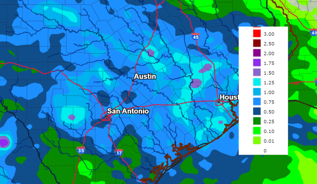
Adding all of the rain over the next 3 days together, totals are forecast to generally average between 1 and 1.5 inches. But do keep in mind, isolated heavier totals will be possible at a few locations.
NWS Rainfall Forecast for the Period 7 pm Thursday through 7 pm Sunday:
The outlook for Monday calls for dry and sunny. A slight chance for rain showers and isolated thunderstorms is forecast next Tuesday through Thursday as a trough of low pressure slowly spreads east across the southern Plains and North Texas. Rain amounts are not expected to be very heavy.
Bob
Social Media