This weekend’s trough of low pressure and cold front brought some much needed rain to the region. Totals were highest across the northern Hill Country, where amounts of 2-3 inches were recorded to the north and northwest of Lake Brownwood. The western half of the Hill Country received between 1 and 1.5 inches, while the eastern half saw totals closer to a half inch. Amounts were much lower across Central Texas and the middle Texas coast, where most totals were under a quarter inch.
Some pockets of heavy rain developed Monday morning along the middle Texas coast in the vicinity of the stalled out cold front. LCRA’s gauge located near Sargent, in southeastern Matagorda County, recorded 4.21 inches, while LCRA’s gauge near the town of Matagorda, in southern Matagorda County, recorded 3.01 inches. (as of 2:30 pm)
We’re looking at an unsettled weather pattern this week as a series of low pressure troughs push east out of Mexico and track across Texas. This development is something we haven’t seen much of this spring, and should lead to periods of rain and thunderstorms across our region. Unfortunately, the highest totals of rain are expected to be across the northern and eastern parts of the state.
Monday’s weather will be sunny and warm for the majority of the region. However, there will be a 40-50 percent chance for scattered showers and thunderstorms for the coastal plains Monday afternoon and Monday evening, for the area to the south of U.S. Highway 59. Additional totals of 0.5 t0 1 inch will be possible. The cold front along the coast is predicted to lift back to the north Monday night, allowing warm and more humid air to spread back over the area.
- High temperatures Monday are forecast to generally be in the low and mid-80s, with some upper 80s possible across parts of Central Texas
- Lows Tuesday morning will range from the low 60s across the Hill Country, to the upper 60s near the coast
Widespread low clouds and even some patchy fog are forecast to develop Monday night, continuing through Tuesday morning. A partly cloudy sky is expected Tuesday afternoon. Due to increasing moisture and a slightly unstable air mass, a few scattered showers and isolated thunderstorms will be possible Tuesday afternoon and Tuesday evening. Forecasts point to the possible development of scattered thunderstorms late Tuesday afternoon into Tuesday evening across West Texas, along the dry line. Should thunderstorms develop, the atmospheric setup will allow some of these storms to become strong to severe. High resolution forecasts call for the developing storms to track to the east, possibly spreading over parts of the Hill Country and Central Texas Tuesday night into early Wednesday morning. Some of these storms may be strong to severe. Rain amounts from this wave of showers and thunderstorms is forecast to generally average between 0.25 and 0.5 inches.
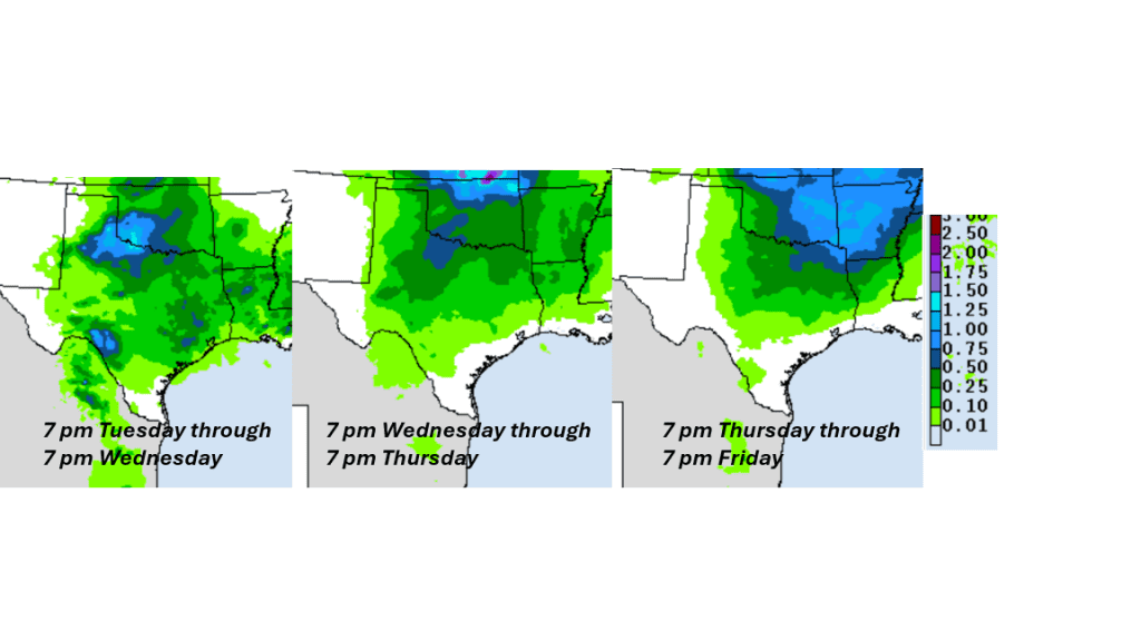
The highest chance for rain and scattered thunderstorms this week is expected to occur Wednesday and again on Thursday as two separate waves of low pressure track east across North Texas. On Wednesday, showers and scattered thunderstorms are forecast to increase in coverage in the afternoon and continue into Wednesday evening. The probability for rain will be near 50 percent. Scattered rain showers and thunderstorms are forecast to increase in coverage again Thursday afternoon and continue Thursday night into Friday as the second wave of low pressure moves over the area. The probability for rain will be near 50 percent. The chance for rain looks to decrease Friday afternoon into Friday night. Rain amounts Thursday through Friday are forecast to average around a quarter inch, with isolated heavier totals.
A breakdown of this week’s forecasted rain, from the National Weather Service:
For the weekend, there will be a slight chance for a few showers on Saturday. Otherwise, the weekend is expected to be partly cloudy and warm, with highs around 88-90 degrees.
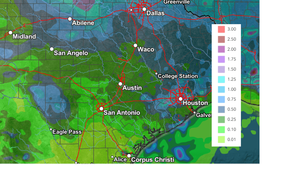
Cumulative rain totals through Saturday evening call for widespread totals between 0.25 and 0.5 inches, with isolated heavier totals.
NWS Rainfall Forecast Valid through 7 pm Saturday:
Looking ahead to next week, forecast solutions call for generally dry and warm weather next Monday and Tuesday, followed by a chance for scattered rain showers and thunderstorms next Wednesday through Friday as a weak cold front sinks to the south and stalls across Central Texas. High temperatures next week are forecast to hold in the mid and upper 80s.
Have a great week!
Bob
Social Media