The first ten days of October have been anything but fall-like. While nighttime temperatures have been fairly comfortable, afternoon readings have been more like that of late June and early July. The average temperature across the region through October 10th has been close to 5 degrees above normal and this period ranks among the hottest starts to October on record.
Unfortunately , the unseasonably hot weather is going to continue for a few more days yet. In fact, some of the hottest temperatures of the current hot spell are forecast to occur on Sunday and Monday. Increasing subsidence from the stubborn heat dome to our west, an area of warm air spreading east out of Mexico, and nearly unlimited sunshine will combine to produce a summer-like pattern. Even though it’s October, be sure to remember heat safety precautions! On the positive side, dry air will remain in place into early next week, keeping relative humidity levels low. This will also allow nighttime temperatures to cool into the 60s.
- High temperatures Friday and Saturday are forecast to be in the mid-90s across Central Texas, and in the low 90s across the Hill Country and coastal regions
- High temperatures Sunday and Monday are forecast to be in the upper 90s across Central Texas, and in the mid-90s across the Hill Country and coastal plains
- Lows Saturday morning through Tuesday morning will generally be in the low and mid-60s
Finally, a break from the ongoing summer-like weather is on the horizon! A strong trough of low pressure in the upper atmosphere is forecast to develop south from eastern Canada into the Tennessee Valley early next week. The trough is forecast to nudge the Southwestern heat dome to the west. At the same time, it will allow cooler air to flow south into the southern U.S. Forecasts show the bulk of the cool air will take aim on the Deep South and the Southeastern U.S., meaning a less dramatic cooldown for Texas. However, a noticeable change can be expected.
The cold front is predicted to reach the northern Hill Country and the eastern counties of Central Texas around sunrise Tuesday, then spread to the west and south Tuesday afternoon into Tuesday night. With so little moisture in place, no rain is forecast with the front. Sunny, cooler, less hot weather looks to follow the cold front beginning Tuesday afternoon, continuing through late next week. Breezy northeasterly winds of 10-20 mph are forecast Tuesday afternoon and evening.
- High temperatures Tuesday are forecast to be near 88-90 degrees across the Hill Country and Central Texas regions, and into the low 90s across the coastal plains
- High temperatures Wednesday through Friday are forecast to generally be in the mid and upper 80s
- Lows next Wednesday through Friday morning are forecast to be in the low and mid-50s across the Hill Country, and in the mid and upper 50s across Central Texas and the coastal Plains
Next Saturday, milder and more humid air is forecast to return off the Gulf of Mexico ahead of a Pacific cold front pushing southeast out of the Rockies. The front is predicted to push southeast across Texas on Sunday, possibly accompanied by a few rain showers and scattered thunderstorms. As of now, the rain is not shaping up to be all that heavy. This will be followed by a return to a dry weather pattern on Monday the 21st. Mild temperatures are forecast next weekend into the following week, with highs in the 80s and lows in the 60s.
Tropical Weather Outlook
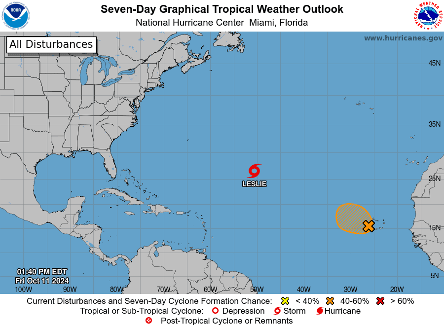
- The remnants of Milton have become non-tropical and are currently spreading south of Bermuda
- Tropical Storm Leslie continues across the central tropical Atlantic. Leslie is forecast to track east-northeast across the open Atlantic over the next few days. At the same time, the system is forecast to lose its tropical characteristics and become post-tropical
NHC forecasters are keeping a close watch across the far eastern Atlantic where very recent satellite-derived wind data indicates winds to tropical storm force are occurring over portions of the Cabo Verde Islands. These strong winds are associated with an area of low pressure centered near the southwestern portion of the archipelago. Satellite data shows the circulation is elongated, and the associated shower and thunderstorm activity remains disorganized. Some tropical development will be possible, and a short-lived tropical storm could form while the system moves westward or west-northwestward at 10 to 15 mph across the Cabo Verde Islands and eastern tropical Atlantic today. On Saturday, environmental conditions are forecast to become less conducive, and further development appears unlikely after that time.

Elsewhere, conditions are quiet. There are no systems in place which pose a threat for tropical development over the next 5 to 7 days.
Comet Tsuchinshan-ATLAS Update (pronounced “Choo-chin-SHAHN”)
The comet is beginning to enter its week of glory for those of us in the Northern Hemisphere. It has swung around the Sun and will emerge into evening view beginning Friday evening. Unfortunately, the comet will be very low—just above the horizon due west in twilight through the weekend. It will be extremely hard to view with the unaided eye. Binoculars night help you pick it up through the fading afterglow of day. It will likely appear tiny, with its bright inner tail curving to the right. The comet will set while twilight is still fairly bright.
Next week, the comet will be easier to view as it climbs higher in the western sky and sets later. I’ll provide another viewing update Monday.
Have a great weekend!
Bob


Social Media