Windy conditions with gusts to 40-45 mph occurred Sunday in the wake of a cold front and storm system which passed north of our area. A strong pressure gradient behind the departing storm system will keep conditions breezy this afternoon. Gusts to near 25 mph can be expected through late afternoon. Wind speeds should finally diminish to around 5-10 mph Monday evening.
Moisture wrapping around the storm system to our east will keep this afternoon’s sky mostly cloudy to partly cloudy. However, no precipitation is forecast. Afternoon temperatures should top out in the low 60s. Monday night is shaping up to be the chilliest night of the week. Under a clear sky, lows Tuesday morning will generally be in the upper 30s to low 40s.
A mostly sunny to partly cloudy sky is forecast Tuesday through Wednesday as a ridge of high pressure spreads over Texas out of northern Mexico. High temperatures both days are predicted to be near 68-70 degrees. Lows Wednesday morning are forecast to be in the low and mid-40s. Breezy conditions look to develop across the region Wednesday in advance of a Pacific storm system tracking east across the southern Rockies. Expect southerly breezes of 15-25 mph with gusts to 25 mph Wednesday and Wednesday night.
Thursday and Friday’s weather will feature a mostly cloudy sky as considerable moisture is drawn north from the Gulf of Mexico. A Pacific cold front is forecast to slowly push east out of West Texas, then stall somewhere across the Hill Country Thursday afternoon and Thursday night. There may be just enough moisture in place to cause a few spotty light rain showers for areas along and east of Interstate 35 Thursday afternoon through Friday afternoon. The probability for rain will only be 20 percent and rain amounts should total less than a tenth of an inch. High temperatures both days are predicted to be near 70-72 degrees.
A cloudy and somewhat unsettled weather pattern is forecast Saturday through next Monday as a Pacific trough of low pressure slowly dips south out of the southern Plains and moves across Texas. The approaching trough is forecast to cause a 30-40 percent chance for rain showers and isolated thunderstorms Saturday through Sunday, with the chance for rain increasing to 50 percent on Monday. Similar to the past couple of rain events, the best chance for rain this upcoming period looks to be focused over areas along and east of Interstate 35 and not as much across the Hill Country. The chance for rain should end from west to east late Monday as the trough exits to the east.
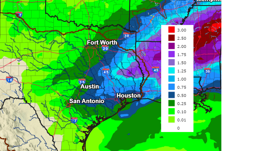
Rain amounts Saturday through Monday are forecast to average around a quarter inch or less across the Hill Country. For the rest of the area, totals should generally average between 0.5 and 1 inch.
NWS Rainfall Forecast Valid through 6 pm Next Monday, February 12th:
Weekend high temperatures are forecast to be in the upper 60s. Lows are predicted to be in the 50s.
Mostly sunny and dry weather is forecast next Tuesday through Thursday as a weak ridge of high pressure spreads over Texas. Expect high temperatures in the 60s and low temperatures in the 40s. Forecasts point toward an increasing chance for rain across the area next Friday, continuing into next weekend.
Long-range forecast data does not show any arctic air headed for Texas over the next two and a half weeks.
Have a good week.
Bob
Social Media