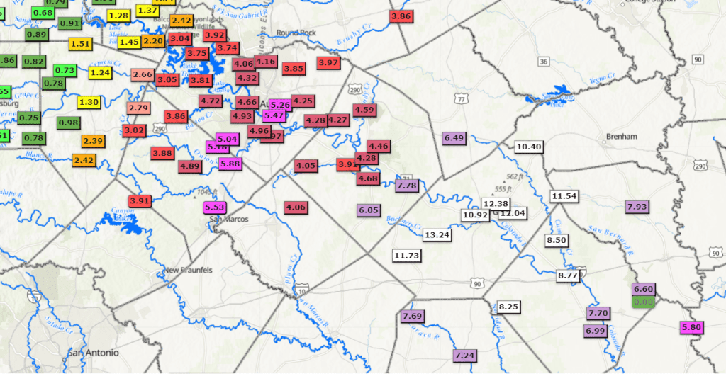
It was quite a week of rain for the eastern half of Texas! Numerous waves of low pressure moving across Texas produced several inches of rain over the area along and to the east of Interstate 35. In some cases, nearly a foot of rain was measured! By far, the highest totals of rain occurred along a southwest to northeast zone stretching from Gonzales, to La Grange, Brenham, and Huntsville where storms trained for several hours Tuesday evening. For the week, the rain here totaled between 10 and 15 inches! LCRA’s highest 5-day gauged total was 13.24 inches at the location Buckners Creek near Muldoon, in western Fayette County. LCRA’s gauges across the remainder of Fayette County all recorded between 10 and 12 inches. The rain was so heavy, it caused quite a bit of localized flooding. This magnitude of rain during the middle of winter is nearly unprecedented in the historical record.
- Austin-Camp Mabry’s total since Sunday totals 4.46 inches. Month to date, the rain measures 6.07 inches. January 2024 currently ranks as the 5th wettest January on record.
- Austin-Bergstrom’s totals since Sunday has totals 4.94 inches. Month to date, the rain measures 6.77 inches. January 2024 currently ranks as the 5th wettest January on record.
LCRA Hydromet Summary of Rain Falling Between 6 am Sunday and 6 am Thursday:
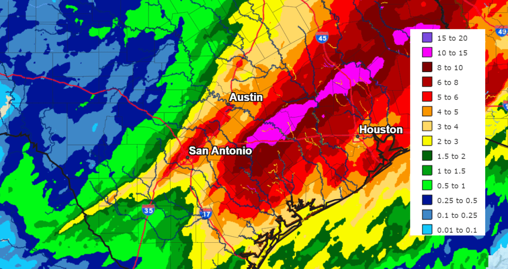
With this week’s rain event focused mainly along and to the east of Interstate, totals across the Hill Country ended up being considerably lower. For some reason, the Balcones Escarpment seemed to be the diving line between the heavy downpours and just a gentle rain. It caused quite the contrast! Doppler radar rainfall estimates and gauge totals showed this week’s rain measured less than a half inch for areas west of a line stretching from Fredericksburg, to Menard, and San Saba. Totals across the eastern Hill Country were generally between a half inch and one inch.
NWS Doppler Radar Estimate of Rain Falling Between 6 am Sunday and 6 am Thursday:
Bob
Social Media