Without much warning, it seems summer arrived over the weekend. Temperatures spiked well in the 90s, with low 100s occurring across the western Hill Country and Edwards Plateau. At the same time, the rain and storms turned off as the summer heat dome spread over Texas out of Mexico. Fortunately, we’re not into the doldrums of summer just yet and some variability in the weather pattern can still be expected over the next few weeks. But like it or not, warm to hot temperatures are in the forecast for the rest of May and early June.
Sunny, hot, and very stable weather conditions are in place as we start off the workweek. Monday’s analysis showed the heat dome stretching from northern Mexico, north through the southern two-thirds of Texas. Forecasts call for the heat dome to shift eastward to the western Gulf of Mexico and the southeastern U.S. by Wednesday as a trough of low pressure digs into the Southwestern U.S. The heat dome is predicted to remain over this general area through the weekend, then build back across Texas early next week.
For this afternoon and Tuesday, little change in the weather can be expected. Widespread low clouds look to develop after midnight Monday night persist into Tuesday morning. This will be followed by mostly sunny conditions Tuesday afternoon. Breezy conditions are forecast. Expect a southerly breeze at 10-15 mph, with occasional gusts to 25 mph through Tuesday night.
- High temperatures Monday and Tuesday are forecast to generally be in the low to mid-90s.
- Lows Tuesday and Wednesday mornings will range from the low 70s across the Hill Country, to the upper 70s near the coast.
Wednesday through Thursday, some slight changes in the weather pattern are forecast for the Hill Country and parts of Central Texas as a couple of troughs of low pressure track east across the Desert Southwest. The first trough is expected to cause a few scattered thunderstorms to develop across near the Rio Grange and the Concho Valley regions Wednesday afternoon. Any storms which happen to develop are forecast to track east into parts of the Hill Country and possibly as far east as the Interstate 35 corridor Wednesday evening. Some of these storms could be strong to severe.
A second trough of low pressure pushing east out of the Desert Southwest on Thursday is predicted to cause thunderstorms to develop along the dry across West Texas Thursday afternoon. These developing storms are forecast to track east across the Hill Country and parts of Central Texas late Thursday afternoon and Thursday evening. Once again, some of these storms may be strong to severe, possibly causing large hail and damaging winds.
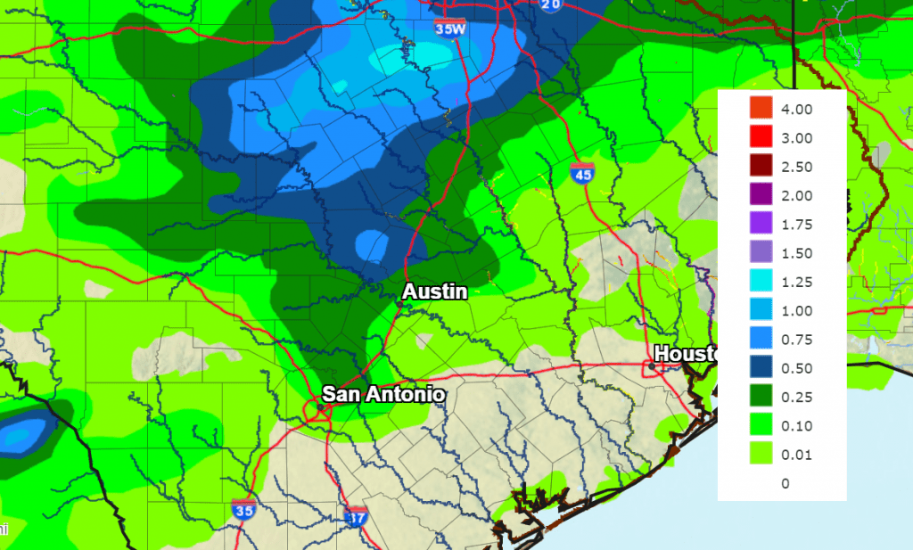
Spotty rain amounts of 0.25 to 0.5 inches are forecast Wednesday through Friday, with isolated totals to near 1 inch possible.
NWS Rainfall Forecast for the Period 7 pm Monday through 7 pm Friday:
Mostly sunny, breezy and warm weather will continue both days. Expect high temperatures in the low 90s, with lows in the mid-70s.
Storm chances will diminish Friday as the trough of low pressure exits to the northeast. However, a couple of isolated thunderstorms will be possible across the western and northern Hill Country Friday through Sunday as the ridge of high pressure or heat dome remains just to our east.
Friday through Memorial Day, expect continued mostly sunny, breezy, and hot weather. Daily high temperatures are predicted to be in the mid-90s, with lows in the mid-70s. Some upper 90s will be possible on Sunday and Monday. Higher relative humidity levels are predicted over the weekend and into early next week. The more humid air will combine with the hot temperatures to produce heat index values in the range of 105 to 110 degrees across Central Texas and the middle Texas coast.
Looking out into next Tuesday through Friday, forecasts are pointing to a chance for some rain showers and scattered thunderstorms the middle of week as a weak cold front pushes south across our area. Rain amounts are not shaping up to be very heavy, with most amounts averaging around a half inch. The front is expected to bring slightly cooler air that will lower high temperatures next Wednesday through Friday close to 90 degrees, with lows in the low 70s.
Have a good week.
Bob
Social Media