Weather Outlook for this Week
Very little change in the sunny and hot weather pattern can be expected through Friday. The heat dome will continue to be the biggest influence on region’s weather, despite it’s center shifting away from Texas mid and late week. The sea breeze may generate a few spotty, brief showers across the coastal plains this week, but no significant rain is forecast. Triple-digit high temperatures are forecast for the Hill Country and Central Texas regions through Friday. Elevated relative humidity levels look to continue throughout the week, allowing peak heat index values to climb to 107 degrees across the Hill Country and Central Texas regions, and to between 105 and 110 degrees across the coastal plains.
- High temperatures Monday through Friday are forecast to be near 100-102 degrees across the Hill Country and Central Texas regions, and 95-98 degrees across the coastal region
Beginning this weekend, the heat dome is predicted to shift to the West Coast while a broad trough of low pressure develops across the Midwest and Great Lakes region. The trough will help push a weak cold front south into Texas late Friday into Saturday. Forecasts call for the cold front to stall somewhere across West and North Texas late Friday into Saturday, and will provide the focus for a few showers and thunderstorms. Unfortunately, the chance for rain doesn’t look like it will extend into Central Texas, or locations further south. There will be a 30 percent chance for scattered rain showers and isolated thunderstorms across the northern Hill Country Friday afternoon through Saturday afternoon. Rain amounts should average around a quarter inch or less. Elsewhere, no rain is predicted.
With the center of the heat dome out west this weekend and for much of next week, high temperatures are predicted to lower a couple of degrees. Highs across the Hill Country and Central Texas are forecast to generally be in the upper 90s. Coastal areas should see highs in the low and mid-90s. There are some indications much of the region could see a chance for rain develop the second half of next week when another cold front sags south into the region.
Longer-range forecasts call for the heat dome to shift east to the central and southern Rockies beginning late next week, meaning local temperatures should trend hotter once again.
Tropics Update
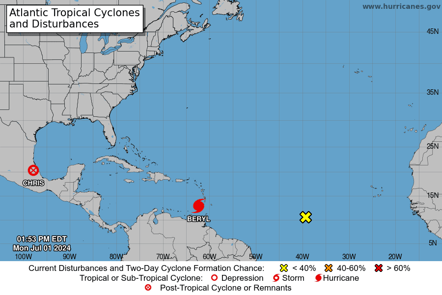
Tropical Depression Three strengthened into Tropical Storm Chris Sunday evening. The tropical storm moved inland over eastern Mexico, just south of Tuxpan, Monday morning. Clouds and heavy rain associated with Chris are currently spreading east across the rugged terrain of eastern Mexico and are forecast to stay well to the south of Texas over the next couple of days.
Hurricane Beryl
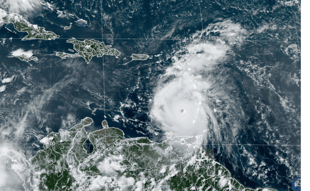
Satellite and radar data suggest Beryl completed an eyewall replacement cycle earlier this morning. Radar images from Barbados now show a solid ring of deep convection surrounding the warming, well-defined eye of the hurricane. Data collected by the NOAA and Air Force Hurricane Hunters this morning confirm that Beryl has strengthened further.

NOAA/Colorado State University/RAMMB 07/01/24 2:10 pm CDT
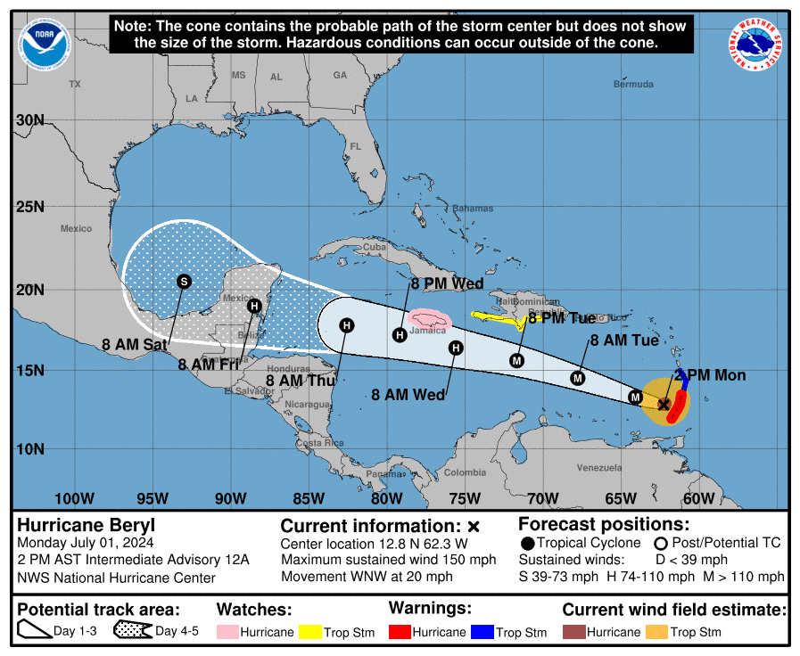
As of 1 pm CDT, the eye of Hurricane Beryl was located about 65 miles northwest of Grenada. Beryl is moving toward the west-northwest near 20 mph. Maximum sustained winds are near 150 mph, with higher gusts. Beryl is a high-end category 4 hurricane on the Saffir-Simpson Hurricane Wind Scale. Fluctuations in strength are likely during the next day or so and Beryl is expected to remain an extremely dangerous major hurricane as its moves over the eastern Caribbean. Beryl remains an impressive hurricane for this part of the Atlantic basin for this time of year.
Beryl continues to move to the west-northwest at around 20 mph. A slight increase in forward speed is expected over the next 24-36 hours as the hurricane remains on the south side of strong ridge of high pressure over the Atlantic. The center of Beryl will move away from the southern Windward Islands tonight and pass quickly westward to west-northwestward during the next few days. On the forecast track, the center of Beryl will move across the southeastern and central Caribbean Sea tonight through Wednesday.
The latest guidance and ensembles have shown a fairly significant adjustment of the track forecast to the left,( or south) as the hurricane approaches the Yucatan Peninsula late this week as a result of stronger mid level ridging over the southern US and Gulf of Mexico and the potential for Beryl to weaken as it moves toward the western Caribbean Sea. An increase in westerly shear is expected by midweek, which is expected to induce some weakening while Beryl moves across the central and northwestern Caribbean Sea. This is reflected in the latest NHC prediction that follows the multi-model consensus trends. Regardless, Beryl is forecast to remain a powerful hurricane through late this week.

There remains a great amount of uncertainty on the ultimate track of Beryl once it crosses the Yucatan as several factors remain in play. The intensity and location of where Beryl enters the southern Gulf, the intensity of the high pressure ridge over the southern US, and the position and intensity of a trough over the central and northern plains. The majority of the forecast model solutions continue to show a path into northern Mexico, although a turn a little further to the north cannot be ruled out. Stay tuned for further updates over the next few days.
Disturbed Weather in the Central Tropical Atlantic
Showers and thunderstorms continue in association with an area of low pressure located over 1000 miles east-southeast of the Windward Islands. Environmental conditions appear marginally conducive for additional development of this system, and a tropical depression could form by the middle part of this week while it moves generally westward at 15 to 20 mph across the central and western tropical Atlantic.

NHC forecasters are giving this system a 20 percent chance for tropical development over the next two days, and a 50 percent chance for tropical development over the next seven days.
Bob


Social Media