The early-season heat wave intensified over the weekend, bringing most areas the hottest temperatures so far this summer. On Friday, Junction broke its all-time record high temperature when the mercury hit 111 degrees. This afternoon (Tuesday), San Angelo broke its all-time record high temperature, with a reading of 112 degrees. Much of the Hill Country and Central Texas recorded weekend high temperatures between 100 and 105 degrees. But making matters worse was the amazingly humid air! The combination of the very temperatures and the high humidity readings yielded peak heat index, or real feel values close to 115 degrees, or higher.
The hottest temperatures this week are expected to occur Tuesday afternoon. Readings should drop a couple of degrees Wednesday and a couple of degrees further Thursday through Saturday as the heat ridge temporarily shifts west into central Mexico. This looks to only be a short break from the extreme heat as the ridge is forecast to shift back to South Texas Sunday and next week. Daily high temperatures next Monday through Friday are predicted to between 100 and 105 degrees across the Hill Country and Central Texas regions.
Forecasts do show a slight chance for some scattered showers and thunderstorms over parts of the Hill Country and Central Texas Wednesday evening. These storms may be strong to severe, but the chance for rain at any given location will be low. Aside from this one possibility for rain, little to no additional rain is forecast through late next week.
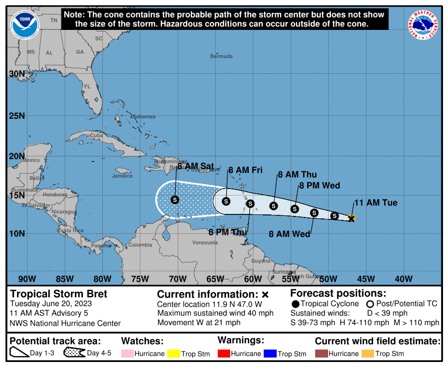
Forecasters are keeping an close watch on tropical storm Bret located in the central tropical Atlantic. Bret is predicted to reach the central Caribbean this weekend, but the latest NHC outlook calls for Brett to dissipate sometime Saturday or Sunday as the storm moves into a region with strong wind shear. Stay tuned for further updates over the next few days.
Here’s a breakdown of this week’s weather:
Tuesday Afternoon through Tuesday Night
Sunny and very hot weather will be in place Tuesday afternoon and evening.
High temperatures are forecast to be near 101-106 degrees across the central and eastern Hill Country, and also across Central Texas. Highs across the western Hill Country are forecast to be near 105-110 degrees. Highs across the coastal plains are forecast to be near 98-100 degrees. Peak heat index values of 110-115 degrees are forecast.
The National Weather Service has posted an Excessive Heat Warning for the entire region through 9 pm Wednesday evening.
Similar to the past couple of afternoons, a few isolated late afternoon and evening thunderstorms will be possible across parts of the western Hill Country and the southern Edwards Plateau. Any activity which happens to develop is forecast to drift from north to south. Developing storms will have the potential to become severe, producing large hail and damaging winds. Isolated totals of 1-2 inches will be possible.
Wednesday through Thursday
Mostly sunny and hot weather will continue, but readings are not expected to be quite as hot as Tuesday’s readings.
High temperatures Wednesday are forecast to be near 100-103 degrees across the Hill Country and Central Texas regions, and in the upper 90s across the coastal plains.
High temperatures Thursday are forecast to be near 98-100 degrees across the Hill Country and Central Texas regions, and in the upper 90s across the coastal plains.
There will be a slight chance for the development of some scattered late afternoon thunderstorms across parts of the Hill Country late Wednesday afternoon as the ridge shifts to the west. Any showers and thunderstorms which happen to develop are forecast to track southeast, bringing a slight chance for thunderstorms to parts of Central Texas Wednesday evening. Some of these storms may be strong to severe, producing large hail and damaging winds. The probability for rain will only be 20 percent.
For locations that do happen to see rain, totals are forecast to average between 0.25 and 0.5 inches, with isolated totals of 1-2 inches possible.
Friday through Saturday
Sunny and hot weather will continue. Little to no rain is forecast.
High temperatures both days are forecast to be near 98-100 degrees across the region. Heat index values to near 110 degrees are forecast.
Sunday through Next Friday
Sunny and very hot weather will be in place as the ridge of high pressure drifts east from central Mexico to South Texas, Temperatures should increase as a result.
High temperatures across the Hill Country and Central Texas are predicted to be around 101-106 degrees. High temperatures across the coastal plains are predicted to be around 100 degrees.
No rain is forecast.
Tropical Weather Outlook
Tropical Storm Bret
As of 10 am CDT, the center of Tropical Storm Bret was located about 945 miles east of the Windward Islands. Bret was moving toward the west near 21 mph, and this general motion is expected to continue for the next several days. On the forecast track, the center of Bret could move across portions of the Lesser Antilles Thursday afternoon through Thursday night. Maximum sustained winds are near 40 mph with higher gusts. Some strengthening is forecast during the next couple of days, and
Bret is expected to be a tropical storm when it reaches the Lesser Antilles Thursday and Thursday night.
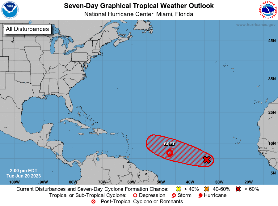
Invest 93
Shower and thunderstorm activity has diminished during the past several hours in association with a tropical wave located several hundred miles southwest of the Cabo Verde Islands. However, environmental conditions appear conducive for further development of this system, and a tropical depression will likely form during the next couple of days while the system moves westward at 10 to 15 mph across the eastern and central tropical Atlantic. NHC forecasters are giving this system a 70 percent chance for tropical development over the next two days.
This system is expected to stay north of the Caribbean Sea.
Summer Solstice Occurs Wednesday
Summer will officially begin Wednesday at 9:58 am CDT. On the solstice, the sun will be directly overhead at noon as viewed from the Tropic of Cancer. For us in the Northern Hemisphere, the June solstice marks the shortest nights and longest days of the year. For the Southern Hemisphere, it marks the longest nights and shortest days. After the solstice, the sun will begin moving southward in our sky again. At the June solstice, the sun rises and sets farthest north on the horizon, and is closest to being overhead at local noon.
Bob
Social Media