The month of July spoiled us, with below normal temperatures and above normal rainfall. For most of the region, the temperature averaged around 1 degree below normal and rainfall totaled at least 2-3 inches above normal. Rainfall at many locations was 5-8 inches above normal. Not bad for what is typically the driest and second hottest month of summer.
August is here and unfortunately, there are no traces left of that tolerable July pattern. The heat dome, which had vacated to the west and east of Texas for most of July has made an unwelcome return. Friday’s analysis showed the heat dome stretching from the Pacific Northwest, to the southern Gulf of Mexico. The dome was centered over western Colorado. Forecasts call for the heat dome to retreat a little further to the west this weekend, then expand east to cover all Texas beginning early next week. With the heat dome now the dominant weather feature going forward, we’re looking an extended stretch of hot and most dry weather. (which is very typical of the month of August)
Friday’s weather is expected to be sunny and hot. High temperatures are forecast to range from 100-102 degrees across the Hill Country, to 98-100 degrees across Central Texas, to the mid-90s across the coastal plains.
This weekend’s weather will include a slight chance for a few scattered rain showers and isolated thunderstorms as weak cold front pushes south and stalls across North Central Texas. This boundary is expected to be the focus for the development of scattered rain showers across North Texas Saturday afternoon. Some of these showers are expected to drift south into the northern counties of the Hill Country and Central Texas late Saturday afternoon and evening. The probability for rain will only be 20 percent. There will be a slight chance for rain showers and isolated thunderstorms across the entire region Sunday afternoon as the boundary sags a little further to the south. Again, the chance for rain will only be 20 percent. Some of the stronger storms could produce wind gusts of 40 mph. For areas that do happen to see any rain, amounts are predicted to stay below a quarter inch, with isolated totals to near 1 inch.
Weekend temperatures will feature dangerous heat, with Saturday expected to be the hottest of the two days. Peak heat indices are forecast to be near 108-111 degrees Saturday, and near 103-106 degrees Sunday.
- Highs Saturday are forecast to be near 100-102 degrees across the Hill Country and Central Texas, with upper 90s across the coastal plains
- Highs Sunday are forecast to be near 98-100 degrees across the Hill country and Central Texas regions, and in the mid-90s across the coastal plains
The outlook for next week calls for sunny, dry, and continued hot weather as the heat dome spreads back across Texas. Daily high temperatures are predicted to be near 98-101 degrees across the Hill Country and Central Texas regions, and in the mid to upper 90s across the coastal plains. Forecasts show similar hot and dry conditions continuing through the middle of the month.
From a climate perspective, the next two weeks are typically the peak of summer temperatures, with readings showing a slow decline during the second half of August. Let’s hope this pattern comes true this year.
Tropical Weather Outlook
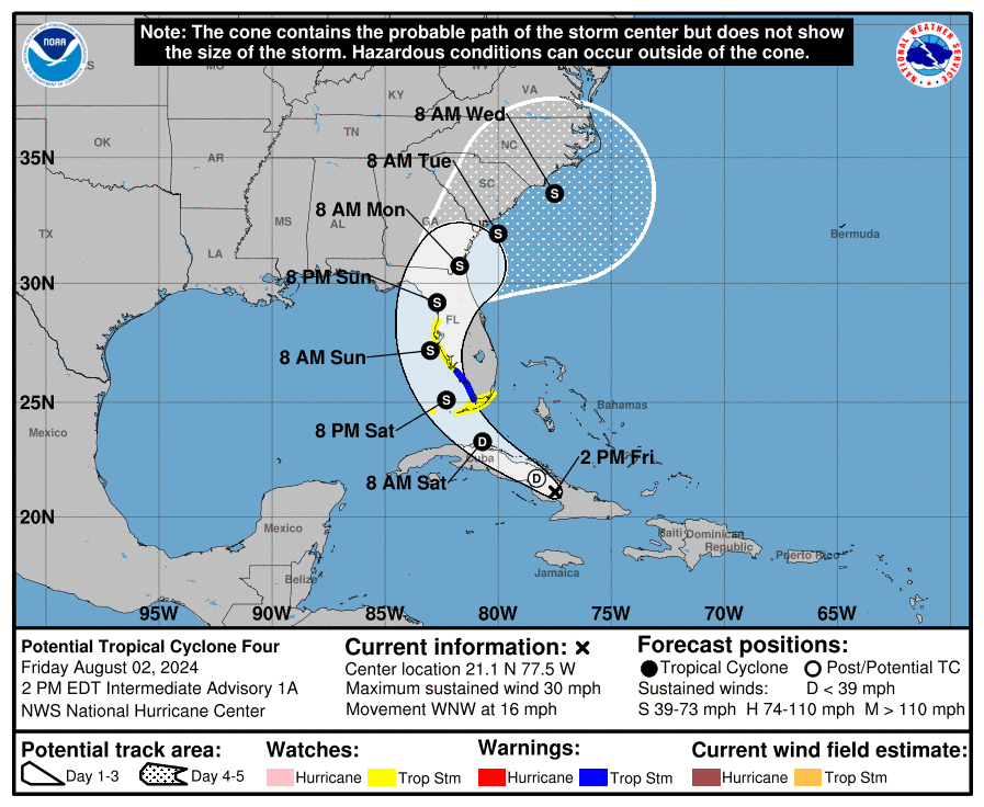
Potential Cyclone Four
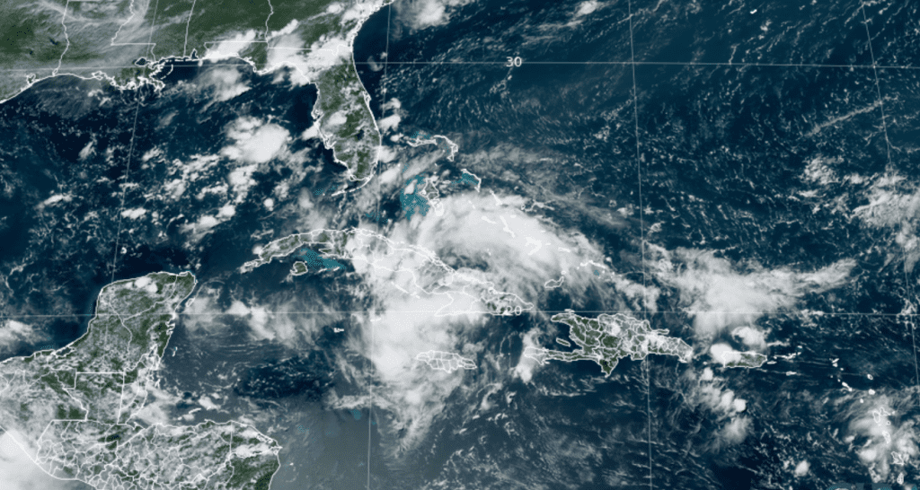
Satellite imagery and surface observations indicate the tropical wave the National Hurricane Center has been monitoring for the last several days is now over southeastern Cuba, with disorganized convective bands to the north and south of a broad low pressure area. Given the potential for development once the system moves over water on Saturday, advisories have been initiated for Potential Tropical Cyclone Four.
As of 1 pm CDT, the strong tropical wave was centered about 360 miles southeast of Key West, Florida. The system was moving toward the west-northwest near 16 mph . A turn toward the northwest at a slower forward speed is expected Friday night and Saturday, followed by a turn toward the north on Sunday. On the forecast track, the disturbance is expected to move over Cuba Friday afternoon, cross the Straits of Florida on Saturday, and then move near or over the west coast of Florida as a tropical storm Saturday night through Sunday night.
Maximum sustained winds were near 30 mph with higher gusts. The disturbance is expected to develop into a tropical depression on Saturday as it moves across the Straits of Florida, followed by intensification into a tropical storm by Saturday night.
Based on the latest forecasts, this system poses no threat to the western Gulf or the coast of Texas.

NOAA/Colorado State University/RAMMB 08/02/2024 1:20 pm CDT

Elsewhere across the tropical Atlantic, conditions are quiet. There are no systems in place which pose a threat for tropical development through late next week.
Have a great weekend!
Bob


Social Media