It’s taken a awfully long time, but it appears the long-running, summer weather pattern is finally on its way out. A large trough of pressure pushing east out of the Rockies has knocked down the persistent heat dome and this will allow cooler air from the Pacific and Canada to flow into Texas. Mostly sunny, dry, and very pleasant weather will be in place this weekend, continuing into early next week.
The first of two cold fronts moved through the area Thursday, bringing widespread rain showers. In the wake of cold front number one, the air is slightly cooler. Friday afternoon’s weather will feature a partly cloudy sky and warm temperatures, with highs generally in the mid to upper 80s. Expect a northeasterly breeze at 10-15 mph.
Cold front number 2, the leading edge of more fall-like air, was located midday Friday across northern Oklahoma. The front is predicted to quickly sink south across Texas late Friday afternoon and Friday night, bringing with it noticeably cooler air and breezy conditions. Northerly winds are forecast to increase to 10-20 mph overnight. With limited moisture in the place, no rain is predicted with the front. Lows Saturday morning will include the mid-50s across the Hill Country, the upper 50s across Central Texas, and the low to mid 60s across the coastal plains.
Mostly sunny and fall-like weather will be in place Saturday and Sunday. Most areas will see the coolest temperatures since early May Sunday morning. Light winds are forecast Saturday night through Sunday.
- High temperatures Saturday are forecast to generally be in the low 70s, with mid-70s towards the coast.
- Lows Sunday morning will be near 48-50 degree across the Hill Country, in the low 50s across Central Texas, and the mid-50s across the coastal plains.
- High temperatures Sunday are forecast to be in the upper 70s.
- Lows Monday morning will generally be in the mid-50s.
For next week, weather conditions are forecast to be mostly sunny and slightly warmer Monday through Tuesday as southeasterly breezes return off the Gulf of Mexico. High temperatures both days are predicted to be in the mid-80s. Lows Tuesday and Wednesday mornings are predicted to be in the low and mid-60s.
The weather pattern is forecast to trend noticeably warmer and less fall-like during the second half of next week. Southerly flow will increase off the Gulf Wednesday and Thursday ahead of a trough dropping southeast out of the Rockies. High temperatures both days are forecast to be close to 90 degrees. There will be a slight chance for rain showers Thursday, with a somewhat better chance for rain and scattered thunderstorms occurring Thursday night into Friday when a cold front moves across the area. As of now, rain amounts are not expected to be very heavy, with most totals staying below a half inch. Cooler air looks to follow the cold front Friday afternoon into next weekend. High temperatures should fall to the 70s, with lows in the 50s.
The sky should clear late next Friday, allowing for a sunny sky next weekend.
Tropical Weather Outlook
Weather conditions are quiet across the Gulf of Mexico and the Caribbean Sea. Tropical cyclone development is not expected over the next few days.
In the tropical Atlantic, Tropical Storm Phillipe became post tropical Friday morning. The system was located a couple of hundred miles south of Bermuda Friday morning. On the current forecast track, the system will pass north of Bermuda late Friday reach the coast of Atlantic Canada or eastern New England Saturday night into Sunday.
In the eastern tropical Atlantic, a low-latitude tropical wave is expected to move off the west coast of Africa later Friday. Thereafter, environmental conditions appear generally conducive for gradual development of the system, and a tropical depression could form by the early to middle part of next week while it moves westward to west-northwestward across the eastern tropical Atlantic.
Annular Eclipse Next Saturday, October 14th
The first of two great solar eclipses is coming up for next Saturday. A “ring of fire” solar eclipse will take place across Texas Saturday, October 14, 2023. It will be visible to those along a narrow path sweeping over North and South America. At mid-eclipse, those along the eclipse path will see the sun in a ring around the moon. Conversely, those outside the shadow path will see a partial solar eclipse. Important: this is not a total eclipse. At no time during this eclipse will it be safe to look at the sun without proper eye protection.
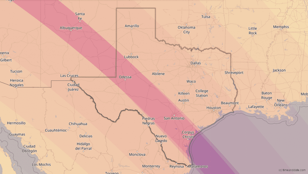
During an annular eclipse, or ring of fire solar eclipse, the moon will cover part of the sun. It will look slightly smaller than the sun, creating the illusion of a ring of fire in the sky. This is due to the moon’s position in its orbit. The path of this eclipse in Texas will be from Midland/Odessa to Corpus Christi. Depending on where you are, this display will last from a few seconds to nearly five minutes. The closer you are to the middle of the eclipse’s path, the more time you’ll get to enjoy that ring of fire.
Across the state, the eclipse will begin at 10:17 am CDT, when the moon will begin to move over the sun. Annularity will begin at 11:41 am and continue through 12:01 pm. The eclipse will end at 1:38 pm, when the moon completely moves away from the sun.
First, and most importantly, protect your eyes. Purchase eclipse glasses or use an indirect observation method, like a pinhole viewer. You must use eye protection to view any part of October’s annular eclipse.
The following map shows the path where the ring of fire eclipse will be visible across Texas. Everywhere within the reddish band will see the ring of fire eclipse. Areas outside of this band will see a partial solar eclipse.
Have a good weekend and enjoy the fall weather.
Bob
Have a good weekend and enjoy the fall weather.
Bob
Social Media