Weather Highlights
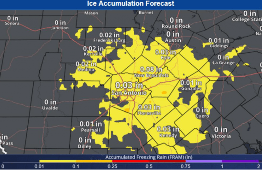
- There will be a low potential for patchy light freezing rain and drizzle across the eastern half of the Hill Country and the Austin/Interstate 35 corridor after midnight Friday night through mid-morning Saturday
- Ice accumulations of just a few hundredths inch are forecast
- Patchy and very light ice accumulations are predicted for exposed surfaces and elevated roadways.
- The threat for freezing precipitation will end by mid-morning Saturday when the temperature warms above freezing
- Periods of light to moderate rain are forecast Saturday afternoon through Saturday night
- A dry and milder weather pattern will begin Sunday and continue through all of next week
Discussion
Cold, arctic air remains entrenched across the area and is expected to remain in place through Saturday, before noticeably milder air returns on Sunday. In addition to the cold air mass, our weather is being influenced by a trough of low pressure located Fridy morning near the Four Corners. The trough is causing southerly winds above the surface across Texas, resulting in widespread overrunning low clouds that will likely persist into Sunday morning. Friday’s clouds are expected to limit any appreciable warmup in the temperature. Friday’s high temperature is forecast to only be in the low and mid-30s across the Hill Country, the mid and upper 30s across Central Texas, and around 40 degrees across the coastal plains. Expect a northeasterly breeze at 5-10 mph Friday afternoon through Friday night.
Friday’s forecast solutions continue to show a low-end potential for the development of light freezing drizzle and light freezing rain across the eastern half of the Hill Country and the Interstate 35 corridor between San Antonio, Austin, and Temple. With the upper trough pushing east out of the Four Corners, moisture levels are forecast to increase across the area Friday night into Saturday. This is expected to cause the development of light precipitation—mainly patchy light drizzle and light rain across most of the region beginning late Friday evening. Meanwhile, the temperature is forecast to fall to, or just below freezing across the Hill Country and the Interstate 35 corridor around midnight Friday night, allowing for the precipitation to change over to patchy light freezing rain and drizzle. Forecast precipitation amounts overnight into Saturday morning call for totals to stay below 0.05 inches. This is expected to result in just patchy and very light ice accumulations on exposed surfaces and elevated roadways.
National Weather Service Forecast for Ice Accumulation through Mid-Morning Saturday:
- Low temperatures Saturday morning are forecast to be near 30-32 degrees across the Hill Country and the I-35 corridor, in the mid-30s across Central Texas and the middle Texas coast.
By mid-morning Saturday, the temperature is predicted to rise above freezing at all locations, ending the threat for freezing drizzle and freezing rain. There will be a 30-40 percent chance for occasional light rain showers across the area Saturday morning through Saturday afternoon. High temperatures Saturday are forecast to generally be in the low 40s.
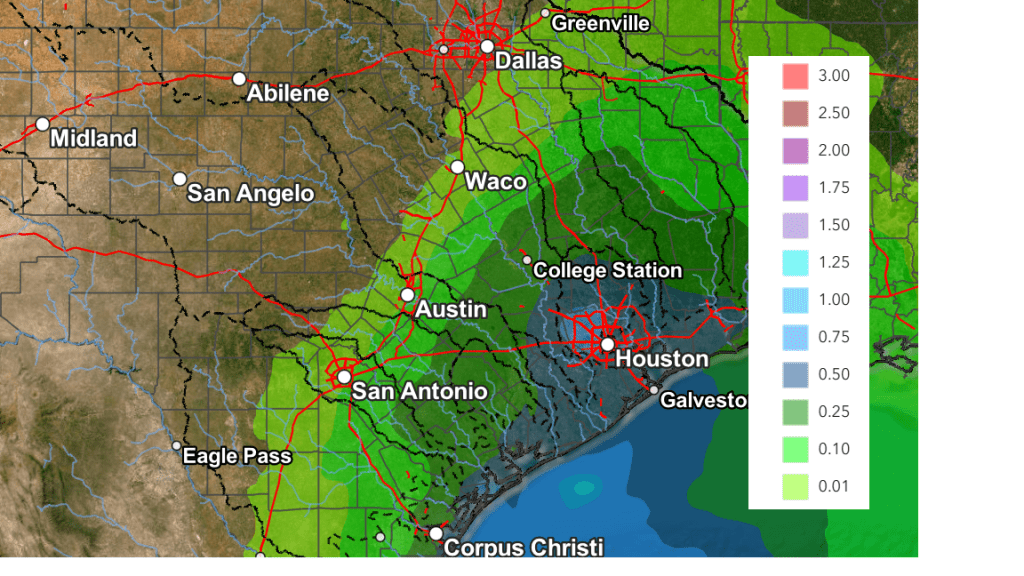
The chance for light to moderate rain showers will increase to 50-60 percent Saturday night as the trough of low pressure tracks across the southern Plains. A couple of isolated thunderstorms will be possible for areas east of Interstate 35. The rain should end from west to east late Saturday night into early Sunday morning. Rain amounts through Sunday morning are forecast to average less than a tenth of an inch across the Hill Country, between a tenth and a quarter inch across Central Texas, and between a quarter and 1 inch across the coastal plains. High temperatures Sunday are forecast to be in the low to mid-60s.
NWS Rainfall Forecast Valid through 6 pm Sunday:
The outlook for next week calls for dry weather and mild temperatures. High temperatures Monday through Wednesday are forecast to be in the upper 70s, with lows in the upper 40s to low 50s. A Pacific cold front will move across the area next Thursday bringing just slightly cooler temperatures for late week. No additional arctic air is seen on the near term horizon.
Have a great weekend!
Bob
Social Media